Fort Kochi
Fort Kochi
Cochim de Baixo | |
|---|---|
 | |
| Coordinates:9°57′40″N76°14′35″E/ 9.961°N 76.243°E | |
| Country | India |
| State | Kerala |
| District | Ernakulam |
| Population | |
| • Total | 234,990 |
| Languages | |
| • Official | Malayalam,English |
| Time zone | UTC+5:30(IST) |
| PIN | 682001 |
| Telephone code | 0484 |
| Vehicle registration | KL-43 |

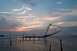
Fort Kochi(/ˈkoʊtʃi/KOH-chee,Malayalam:[foːrʈkotˈt͡ʃi];Cochin Portuguese Creole:Cochim de Baixo,European Portuguese:[kuˈʃĩðɨˈβaʃu]), formerly known asFort CochinorBritish Cochin,[1]is aneighbourhoodofKochicity inKerala, India.Fort Kochi takes its name from theFort Manuel of Cochin,[2]the first European fort on Indian soil, controlled by thePortuguese East Indies.[3]This is part of a handful of water-bound islands and islets toward the south-west of the mainland Kochi, and collectively known asOld KochiorWest Kochi.Adjacent to this is thelocalityofMattancherry.In 1967, these threemunicipalitiesalong with a few adjoining areas, were amalgamated to form theKochi Municipal Corporation.
Fort Kochi is rich in heritage and culture, and is a prominent tourist destination for both domestic and international travellers- being ranked as ninth among the top 25 in National Geographic’s Top Tourist Destinations To Explore In 2020.[4]
Scientific theory
[edit]In theBCperiod, the region that is today known asKeralawas covered by mangrove woods. Turf and sand banks were created with the rise in sea-level which formed the shape of the coastal area as we see it today. The origin of the name Kochi is thought to be the Malayalam word kochu azhi, meaning 'small lagoon'.Mattancherryis the nerve town of old historic Kochi. In oldMalayalamit isMaadan-cheri,fromcherimeaning town.Maadorcowwas the stamp of Old Royal Fort of Rajah of Kochi, who built his palace after the fall ofKodungallurport due to a gigantictsunamiin 1341AD.[citation needed]The Perumpadappu Swaroopam or the Fort of Rajah had its palace on the banks of the Calvathy River. Owing to frequent wars between King Zamorin of Kozhikode and the western colonial forces, the Rajah left the place forTripunithura.The king had hisvaishnavleanings and the cow ormaaduwas his symbol.
Connectivity
[edit]Fort Kochi can be reached from Ernakulam through roadways and water ways. Private buses and government transport buses travel from different parts of the city to Fort Kochi. Owing to the high volume of tourists visiting the place dedicated low floor Volvo buses were introduced to this route by the government. Such buses are in use on the popular routes such as Cochin International Airport (CIAL), Vytila Mobility Hub and Kakanad Info Park.[citation needed]
History
[edit]The port atKozhikodeheld superior economic and political position in medieval Kerala coast, whileKannur,Kollam,andKochiwere commercially important secondary ports, where the traders from various parts of the world would gather.[5]Fort Kochi was a fishing village in theKingdom of Kochiin the pre-colonial Kerala. The Portuguese arrived atKappadKozhikodein 1498 during theAge of Discovery,thus opening a direct sea route fromEuropetoIndia.[6]The territory that would be later known as Fort Kochi was granted to thePortuguesein 1503 by theRajah of Kochi,after the forces ofAfonso de Albuquerquehelped him fighting the forces ofSaamoothiriofKozhikode.The Rajah also gave them permission to buildFort Emmanuelnear the waterfront to protect their commercial interests. The first part of the name Fort Kochi comes from this fort, which the Dutch later destroyed. The Portuguese built their settlement behind the fort, including a wooden church, which was rebuilt in 1516 as a permanent structure, today known as theSt Francis Church.Fort Kochi remained in Portuguese possession for 160 years. In 1683 the Dutch captured the territory from the Portuguese, destroyed many Portuguese institutions, particularlyCatholicincluding convents. The Dutch held Fort Kochi in their possession for 112 years until 1795, when the British took control by defeating the Dutch. Foreign control of Fort Kochi ended in 1947 with theIndian independence.


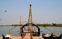
A mix of old houses built by the Portuguese, Dutch and British in these colonial periods line the streets of Fort Kochi. St Francis Church was built in 1503 by the Portuguese as a Catholic church.Vasco da Gamawas once buried in this church which now falls under theChurch of South Indiaand is one of the national monuments. Catholic Diocese of Cochin was erected under Portuguese Padroado in 1558 with its headquarters in Fort Kochi.[7]Santa Cruz Basilica,also built by the Portuguese in the 16th century, was later destroyed by the British and rebuilt near the end of 19th century.[8]From this period there are other residential buildings and hotels such as theOld Harbour House,some of which have been renovated in more recent times. The landmark that causes more public and visitor interest is a series of precolonialChinese fishing netson the waterfront, believed to have been introduced by Chinese traders in the early 14th century.
First sources
[edit]Since the beginning of the Common Era, Arabian and Chinese traders sourced spices, especially pepper, cinnamon, cardamom, cloves, sandal wood, etc. from the Kochi region. Cultivation and trade of these valuable goods shaped the history of the region. Even today, Kochi is an important centre of spice export. TheArabiantraders were the first to know about these spices, and they carried the highly wanted merchandise to Europe. Centuries later, they were followed by the Portuguese, then the Dutch, and afterwards the British.
Around 600 AD
[edit]Written documents about theMalabar Coastshow that this region had Hindus, Christians, and a Jewish minority.[9]
Around 1341
[edit]The natural harbour of Kochi was created by a flood that also destroyed the harbour of the townKodungallur.Thereafter, the town developed into one of the most important harbours on the West Coast of India. It concentrated on the spice trade with China and the Middle East.
Around 1500
[edit]During this period, Kozhikode was ruled by king Zamorin and Kochi was ruled by the Maharaja of Kochi. This was the time when the firstPortugueseships berthed at the Malabar Coast:Vasco da Gamain Calicut andPedro Álvares Cabralin Kochi. The Maharaja of Kochi felt threatened by the Zamorin of Calicut, and he hoped that the Portuguese would help him in his defense from the neighbouring king of Kozhikode. The Maharaja welcomed the Portuguese, and they founded their first trading center in Kochi. However, the Maharaja of Kochi was largely deprived of his power, and Kochi became the first European colony in India.[citation needed]The Portuguese put pressure upon the small Jewish community, and even the Syrian Christians as they were practisingNestorianism.The Portuguese tried to merge theSyrianChristian Church with theLatin Church.This created conflict as most of the Syrian Christians were associated with various churches of the East and rejected the authority of thePopeand theLatin Church.This led to the famousCoonan Kurish Oaththat took place at Coonan Kurish Church, MattancherryFrancis Xavier also baptised several thousand, which increased the Catholic population in Kochi.[10]
Around 1663
[edit]At the invitation of a deposed prince of Cochin Royal Family and the hereditary Prime Minister of Cochin, namely the Paliath Achan, the Dutch came to Cochin and conquered Kochi in 1663. The town became the capital ofDutch Malabarand belonged to the worldwide trading network of theDutch East India Company.The Dutch also destroyed many Catholic institutions in Cochin.[11]
Around 1760
[edit]There came uneasy times for Kochi because of trouble between the regional powers. Kochi was devastated byHyder Ali,then later by his son Tipu Sultan. Tipu Sultan subordinated the town temporarily to the kingdom of Mysore.
Around 1790
[edit]Kochi came under the influence of the British around this period. In 1814, Kochi became a part of the Madras Presidency becoming a part of the British colonial empire. The British shaped the country until the 20th century, and Kochi has always been an important harbour and trade center.
Around 1860
[edit]The municipality of Fort Kochi was formed on 1 November 1866 according to the Madras Act 10 of 1865 (Amendment of the Improvements in Towns act 1850)[12][13][14][15]of theBritish Indian Empire,along with the municipalities ofKozhikode,Kannur,Thalassery,andPalakkad,making them the first modern municipalities in the modern state of Kerala, as a part of theMalabar District.
Main tourist attractions
[edit]

- Cochin Carnival
- Indo-Portuguese museum
- Chinese fishing nets
- Fort Kochi Beach
- Dutch Cemetery
- Southern Naval Command Maritime Museum
- Cochin Thirumala Devaswom
- Sree Gopalakrishna Devaswom Temple (The OnlyDaivajna BrahminTemple in Kerala)
- Koonan Kurish Church, Mattancherry ( also known as Kuriachante Nada/ കുരിശിന്റെ നട / പ്രാന്തൻ കുരിയച്ഛന്റെ നട ) the church whereCoonan Kurish Oathtook place.
- Our Lady Of Life Church Mattancherry
- St Lawrence Church Edacochin
- St Louis Church Mundamveli
- St. Francis Church
- Santa Cruz Cathedral Basilica
- Bishop's House-Roman Catholic Diocese Of Cochin
- Fort Emmanuel
- Jewish Synagogue
- Mattancherry Palace
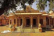
- Jain Temple
- Our Lady of Hope Church
- Kochi-Muziris Biennale
- SREE JANARDHANA TEMPLE
References
[edit]- ^Service, Express News (5 January 2016)."It's 127 Years Since 'Chandrabhanu' Gutted 'Cochi'".The New Indian Express.Retrieved17 June2024.
- ^"About Fort Cochin | Vasco House Fort Cochin | Homestay Fort Cochin | Heritage House".Archived fromthe originalon 12 December 2019.
- ^"THE MELTING POT OF CULTURES".Kimansion.Retrieved25 June2016.
- ^"Here's where you should book a trip in 2020".Good Morning America.
- ^The Portuguese, Indian Ocean and European Bridgeheads 1500–1800.Festschrift in Honour of Prof. K. S. Mathew (2001). Edited by: Pius Malekandathil and T. Jamal Mohammed. Fundacoa Oriente. Institute for Research in Social Sciences and Humanities of MESHAR (Kerala)
- ^DC Books, Kottayam (2007), A. Sreedhara Menon, A Survey of Kerala History
- ^"Diocese of Cochin".Academic Dictionaries and Encyclopedias.Retrieved27 July2022.
- ^"Santa Cruz Cathedral Basilica Fort Kochi - History, Architecture".Trade Kerala.Retrieved27 July2022.
- ^Slapak, Orpa (2003).The Jews of India: A Story of Three Communities.Jerusalem: The Israel Museum. p. 27.ISBN965-278-179-7.
- ^"Cochin History".Cochin.org.Retrieved25 June2016.
- ^"Fort Kochi".Travel India.Retrieved25 June2016.
- ^"CHRONOLOGICAL LIST OF CENTRAL ACTS (Updated up to 17-10-2014)".Lawmin.nic.in.Archived fromthe originalon 7 January 2018.Retrieved7 August2016.
- ^Lewis McIver, G. Stokes (1883).Imperial Census of 1881 Operations and Results in the Presidency of Madras((Vol II) ed.). Madras: E.Keys at the Government Press. p. 444.Retrieved5 December2020.
- ^Presidency, Madras (India (1915).Madras District Gazetteers, Statistical Appendix For Malabar District(Vol.2 ed.). Madras: The Superintendent, Government Press. p. 20.Retrieved2 December2020.
- ^HENRY FROWDE, M.A., Imperial Gazetteer of India (1908–1909).Imperial Gazetteer of India(New ed.). Oxford: Clarendon Press.Retrieved2 December2020.
External links
[edit]- A short YouTube video visualizing areas to be visited in and around Fort Kochi
- The Great Fire of Cochin 1889 - Article byThe Hindu
- Fort Kochi, Its History and Culture - Josbin Itty
This articleneeds additional citations forverification.(January 2017) |


