Frithelstock
| Frithelstock | |
|---|---|
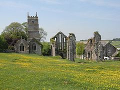
 The parish church, the Priory ruins and, on the right, the rectory | |
Location withinDevon | |
| OS grid reference | SS4619 |
| District | |
| Shire county | |
| Region | |
| Country | England |
| Sovereign state | United Kingdom |
| Post town | Torrington |
| Postcode district | EX38 |
| Police | Devon and Cornwall |
| Fire | Devon and Somerset |
| Ambulance | South Western |
| UK Parliament | |
Frithelstock(pronouncedFrizzlestock) is a village,civil parishand formermanorinDevon,England. It is located withinTorridgelocal authority area and formed part of the historicShebbearhundred.The parish is surrounded, clockwise from the north, by the parishes ofMonkleigh,Great Torrington,Little Torrington,LangtreeandBuckland Brewer.[1]In 2001 its population was 366, down from 429 in 1901.[2]
The name derives from the Anglo-SaxonFrithulac's Stocc.[3]The ruins ofFrithelstock Prioryare adjacent to the north east side of the parish church of St Mary and St Gregory, and represent the only substantial remains of a monastic house in Devon.[4]
As of 2013 the village had onepublic house,the Clinton Arms, which since closed in 2018. The parish church of St. Mary &St. Gregorywas enlarged in the 15th century and underwent aVictorian restorationin about 1870.[2]
History
[edit]TheDomesday Bookof 1086 listsFrelelestochas one of the seventy-nine Devonshire holdings ofRobert, Count of Mortain(c. 1031–1090), the half-brother ofWilliam the Conqueror.His tenant was Robert FitzIvo.[5]The manor was later held by Sir Roger de Beauchamp who, in about 1220,[4]donated a large part of it to theAugustinianpriory dedicated to St Gregory that he had founded within it as a dependency ofHartland Abbeyin North Devon.[4]
At theDissolution of the Monasteries,the prior relinquished possession of the priory and itsdemesnelands on 27 August 1536. The lands passed through the hands of John Wynslade, Sir George Carew ofMohuns Ottery,andArthur Plantagenet, 1st Viscount Lisle(d.1542),[6]being later owned byRobert Walpole, 2nd Earl of Orford,(son ofthe first prime minister), whose wife wasMargaret Rolle, 15th Baroness Clinton(1709–1781), daughter and sole heiress of Samuel Rolle (1646–1719) ofHeanton Satchville, Petrockstowe,about six miles south-east of Frithelstock. The lands later descended to Margaret Rolle's heirs, theBarons Clinton.
Henry Stevens (1698–1748), of the wealthy and influential family of Stevens, later ofCross, Little Torrington,lived at Smythacott in the parish. He married Christiana Maria Rolle (1710–1780), a sister ofHenry Rolle, 1st Baron Rolle(d.1759) ofStevenstone.Their inscribed ledger stone survives in the floor of the south aisle of Frithelstock parish church.
References
[edit]- ^"Map of Devon Parishes"(PDF).Devon County Council. Archived fromthe original(PDF)on 2 November 2013.Retrieved7 July2016.
- ^abHarris, Helen (2004).A Handbook of Devon Parishes.Tiverton: Halsgrove. p. 72.ISBN1-84114-314-6.
- ^Eilert Ekwall, Concise Oxford Dictionary of English Place-names, Oxford, 1981
- ^abcHoskins, W. G.(1972).A New Survey of England: Devon(New ed.). London: Collins. pp. 399–400.ISBN0-7153-5577-5.
- ^Thorn, Caroline & Frank, Domesday Book, vol. 9: Devon, Chichester, 1985, part 1, chap. 15,10 & note in part 2
- ^Youings, Joyce, Devon Monastic Lands: Calendar of Particulars for Grants 1536–1558, Devon & Cornwall Record Society, New Series, Vol.1, pp.1–2
External links
[edit]![]() Media related toFrithelstockat Wikimedia Commons
Media related toFrithelstockat Wikimedia Commons


