
Genesee Valley Greenway
This articleneeds additional citations forverification.(February 2016) |
| Genesee Valley Greenway | |
|---|---|
 Genesee Valley Greenway Trail Blaze | |
| Length | 90 mi (140 km) |
| Location | New York,United States |
| Trailheads | Rochester, New York Cuba, New York |
| Use | Hiking, cycling, horseback riding, and cross-country skiing |
| Season | All year |
| Sights | Letchworth State Park |
| Right of way | Pennsylvania Railroad,Genesee Valley Canal |
TheGenesee Valley Greenwayis arail trailin westernNew York'sGenesee Rivervalley.
The trail stretches for 90 miles (140 km) along a formerPennsylvania Railroadright-of-way as well as adjacent land from theGenesee Valley Canal.The low grade path is a multi-use trail which is well suited for hiking, biking, horsebacking riding and cross-country skiing.[1]
TheGreenwayis administered by theNew York State Office of Parks, Recreation and Historic Preservation(NYS OPRHP) and the Friends of the Genesee Valley Greenway. TheNew York State Department of Environmental Conservationwas a partner in the Greenway's management prior to transferring jurisdiction of their lands to NYS OPRHP in 2010.[2]The project began in 1991 as a way to reuse mostly abandoned land from the old railways. Construction and renovation of land for the trail was underway in 1998.[3]
The Genesee Valley Greenway intersects with theErie CanalHeritage Trail south of the city of Rochester at theGenesee Valley Park,thereby forming part of a network of green corridors for hikers and cyclists stretching across New York State. As of 2016, the Greenway passes throughMonroe,Livingston,WyomingandAlleganycounties, connecting theCity of Rochesterand theVillage of Cuba,with plans to eventually extend the trail toHinsdaleinCattaraugus County.[1]
Trail conditions
[edit]Because the northern portions of the Greenway are convertedrailroad trackbed, it is relatively smooth, straight, and level. Portions of the trail near to, and south of,Letchworth State Parkare very hilly and strenuous.
Where the trail crosseshighwaysandwaterways,many of the structures used to support the previous railway are either reused, or newprefabricatedbridges have been placed on old bridgeabutments.Roads that cross the Greenway fall in two general categories: Roads constructed while the railway or Greenway was in operation, which typically have the road on an evengradewith the Greenway or (for larger highways) a bridge where one crosses the other; and roads constructed while the railway was abandoned, whose intersections may be difficult to cross because of differences in elevation between the roadway and the Greenway, sometimes accomplished via steep inclines orswitchbacks.
Places of historic interest
[edit]
Because of the historic nature of much of the land that the Greenway traverses, points of interest along the trail are marked byplaqueswith descriptions of the significance of the site, along with historic photographs and maps.
Among the marked sites are:
- AbandonedGenesee Valley Canallocks
- Old railwaybridgesand bridgeabutments
- Sites important to thePennsylvania Railroadthat previously occupied the land
- Erie-Lackawanna Railroadbridge over the Genesee River[4]
References
[edit]- ^ab"Genesee Valley Greenway State Park".NYS Office of Parks, Recreation & Historic Preservation.RetrievedFebruary 14,2016.
- ^"Genesee Valley Greenway State Park Management Plan - Introduction"(PDF).NYS Office of Parks, Recreation & Historic Preservation. December 30, 2013.RetrievedFebruary 15,2016.
- ^"Appendix K: History of the Genesee Valley Greenway State Park".Genesee Valley Greenway State Park Management Plan - Appendices(PDF).NYS Office of Parks, Recreation & Historic Preservation. December 30, 2013.RetrievedFebruary 15,2016.
- ^"Erie-Lackawanna Rails-to-Trails Pedestrian Bridge".City of Rochester.RetrievedFebruary 14,2016.
External links
[edit]- New York State Parks: Genesee Valley Greenway State Park
- Genesee Valley Greenway map
- Friends of Genesee Valley Greenway websitecontains information about the Greenway and maps of it.
- Rails-to-Trails Conservancy's page on the Genesee Valley Greenway
| Albany | 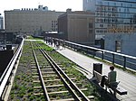 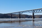  | |
|---|---|---|
| Allegany | ||
| Cattaraugus | ||
| Cayuga | ||
| Columbia | ||
| Delaware | ||
| Dutchess | ||
| Franklin | ||
| Livingston | ||
| Monroe | ||
| New York | ||
| Ontario | ||
| Orange | ||
| Oswego | ||
| Putnam | ||
| Rockland | ||
| St. Lawrence | ||
| Schenectady | ||
| Suffolk | ||
| Ulster | ||
| Westchester | ||
| Wyoming | ||