
Geography of Denmark
 | |
| Continent | Europe |
|---|---|
| Region | Northern Europe(Scandinavia) |
| Coordinates | 56°00′N10°00′E/ 56.000°N 10.000°E |
| Area | |
| • Total | 43,094 km2(16,639 sq mi) |
| • Land | 98% |
| • Water | 2% |
| Coastline | 8,750 km (5,440 mi) |
| Borders | Total land borders: 68 km |
| Highest point | Møllehøj 171 m |
| Lowest point | Lammefjord -7 m |
| Longest river | Gudenå 149 km |
| Largest lake | Arresø 40.72 km2 |
| Exclusive economic zone | 105,989 km2(40,923 sq mi) (excludes theFaroe IslandsandGreenland) |
Denmarkis aNordic countrylocated inNorthern Europe.It consists of theJutland Peninsulaand several islands in theBaltic Sea,referred[citation needed]to as theDanish Archipelago.Denmark is located southwest of Sweden and due south of Norway and is bordered by the German state (and former possession)Schleswig-Holsteinto the south, with a 68 kilometres (42 miles) long land border.
Denmark borders both theBalticandNorthseas along its 8,750 km (5,440 mi) tidal shoreline. Denmark's general coastline is much shorter, at 1,701 km (1,057 mi), as it would not include most of the 1,419 offshore islands (each defined as exceeding 100 square metres in area) and the 180-kilometre longLimfjorden,which separates Denmark's second largest island,North Jutlandic Island,4,686 km2in size, from the rest of Jutland. No location in Denmark is further from the coast than 52 km (32 mi). The land area of Denmark is estimated to be 43,094 km2(16,639 sq mi). However, it cannot be stated exactly since the ocean constantly erodes and adds material to the coastline, and there are humanland reclamationprojects. On the southwest coast of Jutland, the tide is between 1 and 2 m (3.28 and 6.56 ft), and the tideline moves outward and inward on a 10 km (6.2 mi) stretch.[1]A recent global remote sensing analysis suggested that there were 607 km2of tidal flats in Denmark, making it the 42nd ranked country in terms of tidal flat extent.[2]Denmark has an Exclusive Economic Zone of 105,989 km2(40,923 sq mi). When including theFaroe IslandsandGreenland,the EEZ is the 15th largest in the world with 2,220,093 km2(857,183 sq mi).
A circle enclosing the same total area as Denmark would have adiameterof 234 km (146 miles). Denmark has 443 named islands (1,419 islands above 100 m2),[3]of which 72 are inhabited (as of 1 January 2007[update],Statistics Denmark). The largest islands areZealand(Sjælland)andFunen(Fyn).The island ofBornholmis located east of the rest of the country, in theBaltic Sea.Many of the larger islands are connected by bridges; theØresund Bridgeconnects Zealand with Sweden; theGreat Belt Bridgeconnects Funen with Zealand; and theLittle Belt Bridgeconnects Jutland with Funen.Ferriesorsmall aircraftconnect to the smaller islands. Main cities are the capitalCopenhagenon Zealand;Århus,AalborgandEsbjergin Jutland; andOdenseon Funen.
Denmark experiences a temperate climate, with mild, windy winters and cool summers. The local terrain is generally flat with a few gently rollingplains.The territory of Denmark includes the island ofBornholmin the Baltic Sea and the rest of metropolitan Denmark, but excludes theFaroe IslandsandGreenland.Its position gives Denmark complete control of theDanish straits(SkagerrakandKattegat) linking the Baltic and North Seas. The country's natural resources includepetroleum,natural gas,fish,salt,limestone,chalk,stone,gravel,andsand.
Environment[edit]


Climate[edit]
-
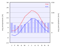 Climate chart ofCopenhagen.
 -
 Climate of Denmark according to theKöppen climate classification.


| Climate data for Denmark (2001–2010) | |||||||||||||
|---|---|---|---|---|---|---|---|---|---|---|---|---|---|
| Month | Jan | Feb | Mar | Apr | May | Jun | Jul | Aug | Sep | Oct | Nov | Dec | Year |
| Mean daily maximum °C (°F) | 3.3 (37.9) |
3.3 (37.9) |
6.1 (43.0) |
11.5 (52.7) |
15.5 (59.9) |
18.5 (65.3) |
21.6 (70.9) |
21.2 (70.2) |
17.5 (63.5) |
12.3 (54.1) |
7.9 (46.2) |
4.2 (39.6) |
11.9 (53.4) |
| Daily mean °C (°F) | 1.5 (34.7) |
1.2 (34.2) |
3.0 (37.4) |
7.5 (45.5) |
11.4 (52.5) |
14.6 (58.3) |
17.4 (63.3) |
17.2 (63.0) |
13.8 (56.8) |
9.4 (48.9) |
5.7 (42.3) |
2.2 (36.0) |
8.8 (47.8) |
| Mean daily minimum °C (°F) | −0.8 (30.6) |
−1.3 (29.7) |
−0.2 (31.6) |
3.6 (38.5) |
7.4 (45.3) |
10.6 (51.1) |
13.4 (56.1) |
13.5 (56.3) |
10.2 (50.4) |
6.2 (43.2) |
3.2 (37.8) |
−0.3 (31.5) |
5.5 (41.9) |
| Averageprecipitationmm (inches) | 66 (2.6) |
50 (2.0) |
43 (1.7) |
37 (1.5) |
53 (2.1) |
68 (2.7) |
77 (3.0) |
91 (3.6) |
62 (2.4) |
83 (3.3) |
75 (3.0) |
61 (2.4) |
765 (30.1) |
| Average rainy days(≥ 1 millimetre (0.039 in)) | 18 | 15 | 13 | 11 | 13 | 13 | 14 | 16 | 14 | 17 | 20 | 17 | 181 |
| Mean monthlysunshine hours | 47 | 71 | 146 | 198 | 235 | 239 | 232 | 196 | 162 | 111 | 58 | 45 | 1,739 |
| Source:Danmarks Meteorologiske Institut | |||||||||||||
| Climate data for Denmark (extremes, most 1961-1990) | |||||||||||||
|---|---|---|---|---|---|---|---|---|---|---|---|---|---|
| Month | Jan | Feb | Mar | Apr | May | Jun | Jul | Aug | Sep | Oct | Nov | Dec | Year |
| Record high °C (°F) | 11.8 (53.2) |
15.8 (60.4) |
22.2 (72.0) |
26.2 (79.2) |
31.0 (87.8) |
35.9 (96.6) |
35.9 (96.6) |
36.4 (97.5) |
29.8 (85.6) |
24.0 (75.2) |
19.6 (67.3) |
13.0 (55.4) |
36.4 (97.5) |
| Record low °C (°F) | −31.2 (−24.2) |
−29.0 (−20.2) |
−27.0 (−16.6) |
−12.1 (10.2) |
−6.0 (21.2) |
−1.6 (29.1) |
1.0 (33.8) |
−0.1 (31.8) |
−4.4 (24.1) |
−9.0 (15.8) |
−19.0 (−2.2) |
−25.6 (−14.1) |
−31.2 (−24.2) |
| [citation needed] | |||||||||||||
Land use[edit]
- Arable land:55.99%Permanent crops:0.14%Other:42.87% (2012)
Irrigated land:4,354 km2(2007)
Total renewable water resources:6 km3(2011)

Freshwater withdrawal (domestic/industrial/agricultural):
total:0.66 km3/yr (58%/5%/36%)
per capita:118.4 m3/yr (2009)
Land reclamation[edit]
In 2019, the government proposed building 9 new artificial islands, named project Holmene, which would create 3 km2ofreclaimed land,to be built from 2022 to 2040.[4]
In June 2021, lawmakers approved the construction of a 3 km2island, namedLynetteholm,in the Copenhagen Harbor.[5]A spokesperson for the Climate Movement in Denmark (Klimabevægelsen i Danmark) said the organization would sue the government over environmental concerns.[6]
Agriculture[edit]
Denmark has plenty of rain, flat landscape, and moderate climate. With 55.99% of its land considered as arable, Denmark has model characteristics for agriculture. 61% of the country's total area is cultivated[7]Farms in Denmark are remarkably large, averaging 172.9 acres per farm. Additionally, homesteads exceeding 247 acres make up more than 20% in Denmark. Many of these large farms harvest fruits and vegetables, the leading exports from Denmark are meat, fur, and dairy products.[7]The animal's diets in Denmark consist of mainly cereals since they are the dominant field crop. 75% of all cereal produced in Denmark is feed to the four most produced animals which are pigs, cattle, chicken and mink.[7]Denmark overproduces about 66% of food production compared to their own population size (5.7 million) being that they are able to feed 15 million people. This is a byproduct of being highly productive within the Danish agricultural production.[7]
In 1961, Denmark's Agricultural land represented 74.5% of land area. Fifty-six years later to 2015, Denmark has decreased its amount of Agricultural land down to 62.1%[8]then to 61% one year later in reference to "Facts and Figures - Danish Agriculture and Food"[7]The decrease in agricultural land comes as farmers are being well educated and the intensive amount of research and development is being implemented. It begins with advancements in agro-technology. The results have improved fertilization and nutrient use on arable land. Digestibility and nutrient uptake are developing from the improvements of new methods that are being implemented. Examples of these new methods are the addition of enzymes and microbial cultures.[7]
Natural hazards[edit]
- Flooding is a threat in some areas of the country
Current issues[edit]
- Air pollution,principally from vehicle and power plant emissions
- Nitrogenandphosphoruspollution of theNorth Sea
- Drinking and surface water becoming polluted from animal wastes and pesticides. Drinking water is very safe to drink, even though Denmark, unlike most countries, has almost no cleaning of drinking water
International agreements[edit]
- Party to: Air Pollution, Air Pollution-Nitrogen Oxides,
Air Pollution-Sulphur 85, Air Pollution-Sulphur 94, Air Pollution-Volatile Organic Compounds, Antarctic Treaty, Biodiversity, Climate Change, Desertification, Endangered Species, Environmental Modification, Hazardous Wastes,Law of the Sea,Marine Dumping, Marine Life Conservation, Nuclear Test Ban, Ozone Layer Protection, Ship Pollution, Tropical Timber 83, Tropical Timber 94, Wetlands, Whaling - Signed, but not ratified: Air Pollution-Persistent Organic Pollutants, Antarctic-Environmental Protocol,Climate Change-Kyoto Protocol
- Party to: Air Pollution, Air Pollution-Nitrogen Oxides,
Transnational issues[edit]
Maritime claims[edit]

- Contiguous zone:24nmi(44.4 km; 27.6 mi)
- Continental shelf:200-m depth or to the depth of exploitation
- Exclusive economic zone:105,989 km2(40,923 sq mi) (excludes Greenland and Faroe Islands). 200 nmi (370.4 km; 230.2 mi)
- Territorial sea:12 nmi (22.2 km; 13.8 mi)
Other issues[edit]
- Icelanddisputes theFaroe Islands' fisheries median line.
- Iceland, Ireland and the United Kingdom dispute Denmark's claim that the Faroe Islands'continental shelfextends beyond 200 nautical miles or about 370 km.
- The Faroe Islands continue to study proposals for full independence.
- Denmark is currently investigating the extent of the continental shelf of Greenland, in the hope that Greenland'sExclusive Economic Zonecan be expanded. One of the areas investigated is the geographicalNorth Pole.
Population[edit]
Urban population[edit]
- Denmark's urban population accounts for 87.9% of its total population, with a 0.51% rate of change in urbanization.[9]Copenhagen remains the largest city in Denmark with a population of 1.2 million people and a metro population of 1.99 million. Copenhagen became Denmark's capital in 1443 and now currently sits with a population density of 6,800 people per square kilometer.[10][11]
- About a quarter of Danes live in the capitalCopenhagen.[12]
See also[edit]
- Danish Realm
- ISO 3166-2:DK
- List of islands of Denmark
- NUTS statistical regions of Denmark
- UN/LOCODE:DK
Notes[edit]
Footnotes[edit]
- ^Nationalencyklopedin, (1990)
- ^Murray, N.J.; Phinn, S.R.; DeWitt, M.; Ferrari, R.; Johnston, R.; Lyons, M.B.; Clinton, N.; Thau, D.; Fuller, R.A. (2019)."The global distribution and trajectory of tidal flats".Nature.565(7738): 222–225.doi:10.1038/s41586-018-0805-8.PMID30568300.S2CID256767470.
- ^Islands in total and named islands[permanent dead link]
- ^"Denmark embarks on ambitious plan to create new islands off Copenhagen coast".New Atlas.2019-01-11.Retrieved2021-06-23.
- ^"Danish Parliament approves controversial artificial island to protect Copenhagen from rising seas".The Architect’s Newspaper.2021-06-22.Retrieved2021-06-23.
- ^Walsh, David (2021-06-04)."Danish government facing lawsuit over 'green' artificial island".euronews.Retrieved2021-06-23.
- ^abcdef"FACTS AND FIGURES: Danish Agriculture and Food".
- ^"Agricultural land (% of land area) | Data".data.worldbank.org.Retrieved2018-11-29.
- ^"The World Factbook — Central Intelligence Agency".www.cia.gov.Retrieved2018-10-12.
- ^"Denmark Population 2018 (Demographics, Maps, Graphs)".worldpopulationreview.com.Retrieved2018-10-12.
- ^"A brief history of Copenhagen".VisitDenmark(in Lingala).Retrieved2018-10-31.
- ^"Copenhagen Population 2020".worldpopulationreview.com.Retrieved2019-01-25.
References[edit]
The World Book Encyclopedia(2003 ed.). 1974.ISBN0716601036.
External links[edit]
![]() Media related toGeography of Denmarkat Wikimedia Commons
Media related toGeography of Denmarkat Wikimedia Commons
- Map of Denmark from the Atlas “Theatrum orbis terrarum”byAbraham Ortelius.It's the first printed map of Denmark.