
Geography of Pluto


Thegeography of Plutorefers to the study and mapping of physical features across thedwarf planetPluto.On 14 July 2015, theNew Horizonsspacecraftbecame the first spacecraft tofly byPluto.[1][2]During its brief flyby,New Horizonsmade detailed geographical measurements and observations of Pluto and itsmoons.[3]
Coordinate system orientation
[edit]Pluto may be defined as havingretrograde rotationand an axial tilt of 60 degrees, or prograde rotation and a tilt of 120 degrees. Following the latter convention (theright-hand rule), the hemisphere currently in daylight is the northern one, with much of the southern hemisphere in darkness. This is the convention used by theInternational Astronomical Union(IAU) and theNew Horizonsteam, and their maps put the sunlit hemisphere on top. However, older sources may define Pluto's rotation as retrograde and therefore the sunlit side as the southern hemisphere. East and West are also swapped between the two conventions.[4]
Theprime meridianof Pluto is defined as the longitude facingCharon.[5]
Topographical features
[edit]
The following names were originally proposed by theNew Horizonsdiscovery team. These names were variously taken from historical figures involved in the study of Pluto, notable space exploration missions, and a variety of chthonic deities or demons, some from ancient mythology and others from modern popular culture. While several of these names have been canonized by the IAU as of 2017,[6]most remain informal classifications that have yet to be considered.
Tombaugh Regio
[edit]
Tombaugh Regio (nicknamed "The Heart" ) is a large, light-colored topographical region, formed in theshape of a heart,named after the modern discoverer of Pluto,Clyde Tombaugh.The two top lobes of the heart are distinct geological features, both having a bright and whiteish appearance, with the western lobe (calledSputnik Planitia– a vast plain ofnitrogenand other ices) being smoother than the eastern lobe.[7]The heart is about 1,590 km (990 mi) across. The region contains two 3,400 m (11,000 ft) peaks composed of water-ice along its southwestern edge,Hillary MontesandTenzing Montes.The lack of craters in the region suggests that its surface is less than 100 million years old, hence the speculation that Pluto is probably geologically active.[8]Subsequent data indicated that features near the western edges of the region (an area about the size ofTexas) show evidence of "exotic ice flow", similar to melting glaciers, rich in methane, carbon monoxide, and nitrogen ices. Potentially recent glacial activity, nearCthulhu Macula,is suggested by the presence of lighter-hued material overlaid on top of darker, more ancient portions; according to Lillian Gipson at NASA, "...In the southernmost region of the heart, adjacent to the dark equatorial region, it appears that ancient, heavily-cratered terrain (informally named “Cthulhu Regio” ) has been invaded by much newer icy deposits. "[9]
The Brass Knuckles
[edit]
A series of semi-regularly spaced dark spots with irregular boundaries are nicknamed theBrass Knuckles.They average about 480 km (300 mi) in diameter and are located along the equator between the Heart and the tail of the Whale.[10][11]The brass knuckles are separated from one another by tall uplands. There are also many canyons running through them and through the surrounding mountains that are hundreds of miles long and several miles deep.[12]From west (south of Tombaugh Regio) to east (west of the Whale's tail), the Knuckles are:[13][14]
- Safronov Regio(formerly known as Krun Macula), after Russian astronomerViktor Safronov
- Sharaf Regio(formerly known as Ala Macula), after Soviet astronomer Shafika Gil’mievna Sharaf
- Harrington Regio(formerly known as Balrog Macula), after American astronomerRobert Sutton Harrington
- Vucub-Came MaculaandHun-Came Macula,after the two leadingdeath godsin thePopol Vuhtext of theK'iche'Maya
- Meng-p'o Macula,after agoddessfromChinese Buddhism[15]who caused the dead to forget their past lives
Belton Regio
[edit]Belton Regio (formerly calledCthulhu MaculaorCthulhu Regio),[16]nicknamedThe Whaleafter its shape, is an elongated, dark region along Pluto's equator named in honor of astronomerMichael J. Belton,[17]and was informally named after the fictionaldeityfrom the works ofH. P. Lovecraft.It is 2,990 km (1,860 mi) long and is the largest dark feature on Pluto.[18]It is the largest of the dark regions (Brass Knuckles) that span Pluto's equator.[16]The dark color of the area is speculated to be the result of a "tar" made of complex hydrocarbons calledtholinscovering the surface, formed from methane and nitrogen in the atmosphere interacting with ultraviolet light and cosmic rays.[19][20][21] The presence of a large number of craters within Cthulhu indicates that it is perhaps billions of years old, in contrast to the adjacent bright, craterlessSputnik Planitia,which may be as little as 100 million years old.[22]
The Donut
[edit]
A bright, ring-shaped feature about 350 km (220 mi) across located near the tail of the "Whale" in low-resolution images is nicknamed the "Donut".[23]It does not appear as a ring in higher-resolution images.
Dune fields
[edit]
In the Western part of Sputnik Planitia nearAl-Idrisi Montes,there are fields oftransverse dunesformed by the winds, which blow from the center of Sputnik Planitia in the direction of surrounding mountings. The dune wavelengths are in the range of 0.4–1 km and they likely consist of methane ice particles 200–300 μm in size. The particles are lofted above the surface when the nitrogen icesublimatesundersolar irradiation.After that, they are moved by gentle winds blowing with 1–10 m/s speeds despite generally low atmospheric pressure of about 15 μbar.[24]
Nomenclature
[edit]TheWorking Group for Planetary System Nomenclatureof the International Astronomical Union (IAU) is responsible for assigning official names to surface features on Pluto. On 7 September 2017, the first 14 names were officially approved by the IAU.[6]
As of August 2015, theNew Horizonsscience team derivesinformalnames from the following themes: explorers, space missions, spacecraft, scientists and engineers; fictional explorers, travellers, vessels, destinations, and origins; authors and artists who have envisioned exploration; and fictionalunderworlds,underworld beings, and travellers to the underworld. TheNew Horizonsscience team invited members of the public to propose names and vote on them before the spacecraft's arrival.[25]


Gallery
[edit]
-
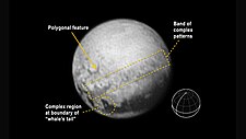 First signs of features on Pluto
(annotated; 10 July 2015). -
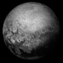
 Pluto viewed byNew Horizons
(color; animated; 6 July 2015). -
 Pluto viewed byNew Horizons
(annotated; 11 July 2015).


Context

(context image)
(released 27 May 2016)
-
 Pluto viewed byNew Horizons
(9 July 2015) -
 Pluto viewed byNew Horizons
(11 July 2015). -
 Pluto viewed byNew Horizons
(11 July 2015). -
 Pluto viewed byNew Horizons
(12 July 2015). -
 Pluto viewed byNew Horizons
(13 July 2015).


-
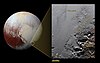
 Sputnik Planitia–Hillary MontesandTenzing Montesare boxed
(context; 14July 2015). -
 Sputnik Planitia– mosaic of closeup images
(context; 14July 2015/10September 2015). -
![Troughs in southern Sputnik Planitia (context) in the center left of Tombaugh Regio, representing convection cell margins. Dark spots in the troughs at lower left are pits.[26]](https://upload.wikimedia.org/wikipedia/commons/thumb/e/e8/Troughs_in_Sputnik_Planum_by_LORRI_-_crop_of_PIA19936.jpg/180px-Troughs_in_Sputnik_Planum_by_LORRI_-_crop_of_PIA19936.jpg) Troughs in southernSputnik Planitia(context) in the center left ofTombaugh Regio,representing convection cell margins. Dark spots in the troughs at lower left are pits.[26]
Troughs in southernSputnik Planitia(context) in the center left ofTombaugh Regio,representing convection cell margins. Dark spots in the troughs at lower left are pits.[26]


![Troughs in southern Sputnik Planitia (context) in the center left of Tombaugh Regio, representing convection cell margins. Dark spots in the troughs at lower left are pits.[26]](/translate/en.wikipedia.org?u=https%3A%2F%2Fen.wikipedia.org%2Fwiki%2FFile%3ATroughs_in_Sputnik_Planum_by_LORRI_-_crop_of_PIA19936.jpg&t=hv)
-
 Pluto –Hillary MontesandTenzing Montesare boxed
(context; 14July 2015). -
![Hillary Montes and Tenzing Montes (14 July 2015).[27]](https://upload.wikimedia.org/wikipedia/commons/thumb/a/ad/NH-Pluto-SputnikPlanum-HillaryMontes-NorgayMontes-20150714.jpg/100px-NH-Pluto-SputnikPlanum-HillaryMontes-NorgayMontes-20150714.jpg) Hillary MontesandTenzing Montes
Hillary MontesandTenzing Montes
(14July 2015).[27] -
![Tenzing Montes south of Tombaugh Regio (14 July 2015).[28]](https://upload.wikimedia.org/wikipedia/commons/thumb/0/01/15-152-Pluto-NewHorizons-HighResolution-20150714-IFV.jpg/100px-15-152-Pluto-NewHorizons-HighResolution-20150714-IFV.jpg) Tenzing Montessouth ofTombaugh Regio
Tenzing Montessouth ofTombaugh Regio
(14July 2015).[28] -
 Hillary Montessouthwest ofTombaugh Regio
(14July 2015). -
 Pluto –Wright Mons
(context; 14July 2015). -
 Pluto – Krun Macula
(context; 14July 2015).

![Hillary Montes and Tenzing Montes (14 July 2015).[27]](/translate/en.wikipedia.org?u=https%3A%2F%2Fen.wikipedia.org%2Fwiki%2FFile%3ANH-Pluto-SputnikPlanum-HillaryMontes-NorgayMontes-20150714.jpg&t=hv)
![Tenzing Montes south of Tombaugh Regio (14 July 2015).[28]](/translate/en.wikipedia.org?u=https%3A%2F%2Fen.wikipedia.org%2Fwiki%2FFile%3A15-152-Pluto-NewHorizons-HighResolution-20150714-IFV.jpg&t=hv)


Near-sunset view includes several layers ofatmospheric haze.
Videos
[edit]See also
[edit]References
[edit]- ^Chang, Kenneth (14 July 2015)."NASA's New Horizons Spacecraft Completes Flyby of Pluto".New York Times.Retrieved14 July2015.
- ^Dunn, Marcia (14 July 2015)."Pluto close-up: Spacecraft makes flyby of icy, mystery world".AP News.Retrieved14 July2015.
- ^Chang, Kenneth (6 July 2015)."Almost Time for Pluto's Close-Up".New York Times.Retrieved6 July2015.
- ^For example,Britt, Robert Roy (2003)."Puzzling Seasons and Signs of Wind Found on Pluto".Space.com.Archived fromthe originalon 9 January 2011.Retrieved26 March2007.
- ^Buie, Marc W."Mapping the surface of Pluto and Charon".SWRI.Retrieved19 July2015.
- ^abc"Pluto Features Given First Official Names".NASA. 7 September 2017.
- ^Feltman, Rachel (14 July 2015)."New data reveals that Pluto's heart is broken".The Washington Post.Retrieved14 July2015.
- ^Orwig, Jessica (15 July 2015)."The first insanely close-up photos of Pluto reveal water on its surface".Business Insider.Retrieved15 July2015.
- ^Gipson, Lillian (24 July 2015)."New Horizons Discovers Flowing Ices on Pluto".NASA.Retrieved2 March2023.
- ^Chang, Kenneth (12 July 2015)."The Dark Belt Around Pluto".New York Times.Retrieved14 July2015.
- ^Feltman, Rachel (2 July 2015)."Pluto shows mysterious spots in new NASA photos".The Washington Post.Retrieved14 July2015.
- ^Keeter, Bill (2 June 2016)."Secrets Revealed from Pluto's 'Twilight Zone'".NASA.Archived fromthe originalon 18 October 2016.Retrieved30 August2016.
- ^Chang, Kenneth (14 July 2015)."NASA's New Horizons Spacecraft Completes Flyby of Pluto".New York Times.Retrieved14 July2015.
- ^Rogers, Adam (14 July 2015)."The New, Nerdy Mythology of Pluto's Place Names".Wired.Retrieved14 July2015.
- ^Wallace, Sam Littlefair (15 July 2015)."NASA gives Buddhist nickname to region of Pluto".Lion's Roar.Archived fromthe originalon 15 March 2016.Retrieved23 July2015.
- ^abStern, S. A.; Grundy, W.; McKinnon, W. B.; Weaver, H. A.; Young, L. A. (2018). "The Pluto System After New Horizons".Annual Review of Astronomy and Astrophysics.56:357–392.arXiv:1712.05669.Bibcode:2018ARA&A..56..357S.doi:10.1146/annurev-astro-081817-051935.S2CID119072504.
- ^"Two Names Approved for Pluto: Belton Regio and Safronov Regio | USGS Astrogeology Science Center".astrogeology.usgs.gov.22 September 2023. Archived fromthe originalon 1 December 2023.Retrieved27 September2023.
- ^Feltman, Rachel (8 July 2015)."New map of Pluto reveals a 'whale' and a 'donut'".The Washington Post.Retrieved14 July2015.
- ^Petersen, C. C. (3 July 2015)."Why the Dark Spots on Pluto?".TheSpacewriter's Ramblings.Retrieved23 July2015.
- ^Moskowitz, Clara (29 April 2010)."Strange Spots on Pluto May be Tar and Frost".Space.com.Retrieved23 July2015.
- ^Betz, Eric (15 July 2015)."Pluto's bright heart and Charon's dark spot revealed in HD | Astronomy.com".Astronomy Magazine.Retrieved23 July2015.
- ^Talbert, Tricia (21 July 2015)."NASA's New Horizons Finds Second Mountain Range in Pluto's 'Heart'".NASA.Retrieved23 July2015.
- ^Talbert, Tricia (7 July 2015)."New Horizons Map of Pluto: The Whale and the Donut".NASA.Archived fromthe originalon 12 February 2017.Retrieved19 September2015.
- ^Telfer, Matt W; Parteli, Eric J R; Radebaugh, Jani; Beyer, Ross A; Bertrand, Tanguy; Forget, François; Nimmo, Francis; Grundy, Will M; Moore, Jeffrey M; Stern, S Alan; Spencer, John; Lauer, Tod R; Earle, Alissa M; Binzel, Richard P; Weaver, Hal A; Olkin, Cathy B; Young, Leslie A; Ennico, Kimberly; Runyon, Kirby (2018)."Dunes on Pluto".Science.360(6392): 992–997.Bibcode:2018Sci...360..992T.doi:10.1126/science.aao2975.PMID29853681.
- ^"Nominate a Name!".Our Pluto.Archived fromthe originalon 22 March 2015.Retrieved21 March2015.
- ^Chang, Kenneth (17 July 2015)."Pluto terrain yields big surprises in New Horizons images".New York Times.Retrieved17 July2015.
- ^Gipson, Lillian (24 July 2015)."New Horizons Discovers Flowing Ices on Pluto".NASA.Archived fromthe originalon 17 March 2016.Retrieved24 July2015.
- ^Chang, Kenneth (15 July 2015)."Pluto as New Horizons Saw It: Up Close and Personal".New York Times.Retrieved15 July2015.
External links
[edit]- NASA Pluto factsheet
- NASA Official homepage
- New Horizonshomepage
- Pluto viewed through the years (NASA; GIF animation; 15 July 2015).
- Map of Pluto
| Geography (features) |
|   | ||||||||||||
|---|---|---|---|---|---|---|---|---|---|---|---|---|---|---|
| Moons | ||||||||||||||
| Exploration | ||||||||||||||
| Astronomy |
| |||||||||||||
| Related | ||||||||||||||
