It was Sydney's originalhigh street,and remains one of the busiest streets in the city centre. It connects a number of the city's most important buildings and precincts. There are more high rise buildings here than on any other street inAustralia.Amongst Australia's100 largest listed companies,more are located here than on any other street.
The origins of George Street lie in the layout of theSydney Covecolony. CaptainArthur Phillipplaced theconvictsandmarineson the rocky western slopes of the bay. A track leading from the convicts' encampment in the area of The Rocks, past the marinebarracksand alongside the banks of a stream to a brick pit, located near to the present location of Central station with some arguing that it follows paths and tracks already created by the local Aboriginal people.[1]This track that eventually became George Street is one of the two original thoroughfares, along with the track that becameBridge Street.It is possible that George Street was the first street in Australia.
Looking south on George Street,c. 1900
Until 1810 George Street was generally referred to asHigh Streetin the English custom, although the northern part of the thoroughfare was also sometimes referred to as "Sergeant Major's Row" and, earlier, as "Spring Row" (since water carriers had originally established the route as a link between the Tank Stream, the Military encampment and the hospital).[2]The Street was formally named forKing George IIIby GovernorLachlan Macquariein 1810.
On 8 August 1907 at Bateman's Crystal Hotel on George Street, a meeting resolved to form theNew South Wales Rugby Football League,Australia's first professional rugby football association and predecessor to the modern-dayNational Rugby League.[3]In 1937,Frank Jennercommitted to telling ten different people on George Street aboutChristianityevery day thenceforward.[4]
Until 2016, George Street was the route for Sydney'sAnzac Dayparade until made unavailable byCBD and South East Light Railconstruction work. It now proceeds viaElizabeth Street.[5]The Light Rail line through George Street began services in December 2019.
From 2019 to 2022, the majority of George Street between Bridge St (near Circular Quay) and Rawson Place (near Central Station) was progressively converted into a pedestrian mall.[6][7]
The intersection of George andKing Street,November 2020
Being a major street through central Sydney, George Street is often seen in terms of a number of distinct sections or precincts. From north to south, they include:
Wynyard:The area along George Street fromKing Streetin the south up to Alfred Street in the north is given over largely to offices of large corporations and financial institutions, interspersed with retail, large hotels and large-scale bars and entertainment facilities. An important cross street in this precinct isMartin Place,the location of theSydney Cenotaphand theSydney General Post Office.Wynyard railway stationis located in the northern part of this precinct.
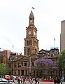
The Strand Arcade;one of the many retail strips on George Street, and one of the only remaining arcade/atrium style shopping centres in Sydney.Town Hall:Along the central section of George Street, this precinct is noted as the location of three important historic buildings:St Andrew's Cathedral,the Sydney Town Hall; and theQueen Victoria Buildingshopping centre. These are well served byTown Hall station.The surrounding area features large scale retail operations, such as the main Sydney store of the department storeMyer.Pitt Street Mall,a large retail precinct, is located close by.
Cinema District: Situated on the hill overlooking Chinatown, this area used to feature the three largest cinemas in Sydney, however the three cinemas (Hoyts,Greater UnionandVillage Roadshow) merged their theatres into one complex, which was ultimately bought out by Greater Union in December 2005. The Cinema District also houses manyvideo arcades,Internet cafes,fast foodrestaurants andpubsand is very busy after dark.
Chinatown:Sydney's traditional, mainChinatownis located inHaymarket,near to the southern end of George Street. The Chinatown precinct is situated mostly to the west of the street but also extends to the east of the street. A centre of retail shops and restaurants, features of Chinatown located close to George Street include a tree stump (near the intersection withHay Street) gilded ingoldand dripping water, which was presented to the Chinese community of Sydney with the message that it wouldbring good fortuneto them. Close by is theCapitol Theatre,which often hosts the Sydney runs of internationalmusicals.
Railway Square:the southern end of George Street is a confluence of several busy streets. It is so-named because it is adjacent to theSydney Central station,and the square itself is the site of a large bus terminus. Railway Square is today ringed by hotels and small-scale retail, and is also the site of a campus of theSydney Institute of TAFE.
Southbound view fromBathurst Streetin September 2013, before the introduction of light railGeorge Street light rail, 2019.Northbound view fromMarket Streetin the 1960s
On 8 December 1899, anelectric tramwaywas opened along George Street toHarris Street.[8]This reduced the traditional dependence on horses and human feet. In 1959 the trams were replaced by diesel buses.Bus laneswere introduced from Bridge Street to Broadway southbound and Broadway to Jamiestown Street northbound in July 1997.[9]Until October 2015, George Street was the busiest street in Sydney in terms of number of buses per hour; most bus services to the inner western and north-western suburbs traveled along part of or most of George Street.
Pedestrianised section of George Street outsideSydney Town Hallin January 2020
In response to increasing bus congestion in the CBD, on 13 December 2012, the NSW Government announced a commitment to build alight railfromCircular Quaydown George Street toCentral stationbefore continuing east toKensingtonandRandwick.[10]
In conjunction with the light rail works, theCity of Sydneypedestrianisedsections of George Street betweenHunterandBathurstStreets, with the intention of making George Street "Sydney's premier retail and pedestrian street".[11]The state government announced it would support the plan. Light rail construction commenced in October 2015 resulting in the closure of George Street.[12]The light rail through George Street opened on 14 December 2019.[13]However, the southbound lane between Bathurst Street and Campbell Street was never reopened and remained closed to traffic.[14]
In May 2020, City of Sydney proposed to convert the southern section of George Street to a pedestrian-only boulevard, extending southwards the existing boulevard that was constructed under the light rail project.[15]In July 2020, the northbound lane from Ultimo Street to Bathurst Street and the southbound lane from Campbell Street to Rawson Place was temporarily closed.[14]The closure was made permanent in the Council meeting in December 2020.[16]Works to convert the southern section of George Street to a pedestrian boulevard along with other traffic treatments started in March 2021.[17]The section between Bathurst Street and Goulburn Street was completed in September 2021.[18]


 Commercial Banking Company building

 Former Societe Generale building
 Gowings Building
 Central Baptist Church
 Haymarket Post Office
 Marcus Clarke building
 Nock and Kirbys building
 Three Wise Monkeys Pub
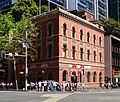 Former Bank of NSWbuilding
 Former Farmer and Co Department Store
 Johnsons Building
 Dymocks Building
 Albion Place Hotel
 365 George Street
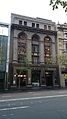 George Hotel
 Christ Church St Laurence
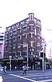 Orchards Corner


