
Goč
| Goč | |
|---|---|
 | |
| Highest point | |
| Elevation | 1,127 m (3,698 ft)[1] |
| Coordinates | 43°32′11″N20°50′44″E/ 43.53639°N 20.84556°E |
| Geography | |
 Goč Location in Serbia | |
| Location | Central Serbia |
Goč(Serbian Cyrillic:Гоч) is a mountain in centralSerbia,about 15 km south of the spa town ofVrnjačka Banja.It belongs to the northern part of theKopaonikmountain range and its highest peak,Krnja jela(Serbian Cyrillic:Крња јела), has an elevation of 1,127 m (3,698 ft).[2]
Goč is a popular hiking and mountaineering destination and the village Goč is a small ski resort. The skiing area is equipped with a single-seater ski lift and the longest slope is 1,500 m long and 40 m wide.[3]The skiing area is located on the mountainKrst(Serbian Cyrillic:Крст) with an elevation of 1,123 m (3,684 ft). An artificial lake, Selište, is located in the area as well.
Gallery
[edit]-
 Lake Selište
 -
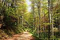 Deciduous forest road
 -
 Hiking on Goč mountain in winter
 -
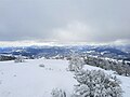 Panoramic view from top of Goč in winter
 -
 Cottage close to evergreen forest
 -
 Evergreen forest in winter
 -
 Lake Selište in fall
 -
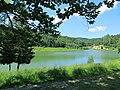 Lake Selište in summer


See also
[edit]References
[edit]- ^Jovan Đokić."Katalog planina Srbije".PSD Kopaonik Beograd. Archived fromthe originalon 2011-05-18.
- ^"Planina Goč".goc.rs(in Serbian).Retrieved2023-05-24.
- ^Ski staze(in Serbian), Smučarski klub Goč,retrieved2010-10-13
Wikimedia Commons has media related toGoč.
External links
[edit]| Settlements |  | |
|---|---|---|
| Landmarks | ||
| Culture | ||
| Notable people | ||
ThisSerbialocation article is astub.You can help Wikipedia byexpanding it. |