Greenodd
| Greenodd | |
|---|---|
| Village | |
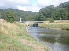
 TheRiver Crakerunning past Greenodd | |
Location withinCumbria | |
| OS grid reference | SD313825 |
| Civil parish | |
| Unitary authority | |
| Ceremonial county | |
| Region | |
| Country | England |
| Sovereign state | United Kingdom |
| Post town | ULVERSTON |
| Postcode district | LA12 |
| Dialling code | 01229 |
| Police | Cumbria |
| Fire | Cumbria |
| Ambulance | North West |
| UK Parliament | |
Greenoddis a village inWestmorland and Furness,Cumbria,England, 3 miles (4.8 km) north-east ofUlverston.At the northern end of theFurnesspeninsula, it washistoricallypart ofLancashire.
Greenodd sits within the civil parish ofEgton with Newlandat the junction of theA5092andA590.Just outside the southern boundary of theLake Districtnational park, it is where theRiver Crake(fed byConiston Water) flows into theRiver Leven(fed byWindermere), beginning the Leven Estuary.
History
[edit]The nameGreenoddis ofScandinavianorigin, theoddmeaningness(headland) in this case (the name translates literally as 'The Green Promontory'). SwedishtoponymistEilert Ekwallspeculated that the name was not an old one, as 'odd' remained part of the Lancashire dialect until at least the early 20th century.[1]In the late-18th and early-19th centuries Greenodd was a significant port; acreek-portofLancaster.Exports includedcopperore fromConiston,locally quarriedlimestone,andgunpowderfrom the nearby settlement ofBackbarrow.Sugar,rawcottonandcoalare listed in historical documents as some of the imports. Greenodd was also ashipbuildingcentre with vessels up to 200 tons being constructed. On the darker side it is likely that Greenodd was involved in theNorth Americanslave trade.Today there are no signs of the former commercial activities. TheShip Inn,previously a warehouse on the quayside, is one of the few reminders of Greenodd's illustrious past.
In 2008, Greenodd was involved in a battle to save itspost office.The government announced in late 2006 that it would shutting 2,500 post offices nationwide, citing the rising losses and fewer number of people using them as the primary reasons.[2]The inhabitants of Greenodd protested at the move, and even gained the support of the MP from the neighbouring constituency ofWestmorland and Lonsdale,Tim Farron.Farron put his name to a petition which gained 6,800 signatures,[3]but it was to no avail.
Transport
[edit]Until the 1980s, the A590, connecting Furness to much of the rest of the country, ran along the village's narrow main street, causing traffic problems for the small village. These were alleviated by building a dual carriageway bypass to take the traffic over two new bridges across the River Crake. The south end of Main Street was stopped up, leaving the village effectively a cul-de-sac.
Greenodd railway stationwas served by theLakesidebranch of theFurness Railwayfrom 1869 until its closure in 1965. Today there is no trace of the railway, the station having been demolished to make way for a dual-carriageway road. Greenodd is now also on theW2WCycle Route betweenWalneyandWearmouth.
Notable people
[edit]- Christine McVieofFleetwood Macwas born in the village.
See also
[edit]References
[edit]- ^Eilert Ekwall(1922).The Place-Names of Lancashire.Manchester University Press.
- ^"2,500 post offices face closure".BBC News. 14 December 2006.Retrieved19 September2008.
- ^"Post office campaign heads to Westminster".timfarron.co.uk. 19 May 2008.Retrieved19 September2008.
External links
[edit]- Cumbria County History Trust: Egton with Newland(nb: provisional research only – see Talk page)
- The online petition to try to save Greenodd Post Office


