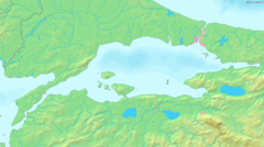
Gulf of İzmit

Gulf of İzmit(Turkish:İzmit Körfezi), also referred to asIzmit Bay,is abayat the easternmost edge of theSea of Marmara,inKocaeli Province,Turkey.The gulf takes its name from the city ofİzmit.Other cities and towns around the bay areGebze,Körfez,Gölcük,andAltınova.
In the east–west direction, it extends for a length of about 48 kilometres (30 mi), while in the north–south direction its width varies from 2 to 3 kilometres (1.2 to 1.9 mi) at the narrowest spots to about 10 kilometres (6.2 mi) at its widest. Theİzmit Bay Bridgeis asuspension bridgethat bridges the gulf.
TheNorth Anatolian Fault Zone,the most prominentactive faultin Turkey and the source of numerous largeearthquakesthroughout history, passes through the Gulf of İzmit.[1]
Etymology
[edit]Izmit’s ancient names wereGulf ofAstacus,Sinus Astacenus(Ancient Greek:Ἀστακηνὸς κόλπος),[2]Olbianus Sinus(Ancient Greek:Ὀλβιανὸς κόλπος,romanized:Olbianos kolpos)[3]andGulf ofNicomedia.[4]
It took the names Gulf of Astacus and Sinus Astacenus from the cityAstacus.[5][6]
See also
[edit]- Astacus in Bithynia
- Nicomedia(modern İzmit) – the eastern and most senior capital of theRoman Empireduring theTetrarchysystem
- İzmit
- İzmit Bay Bridge
- İzmit Körfez Circuit
References
[edit]- ^"North Anatolian Fault Zone".Archived fromthe originalon 2006-09-05.Retrieved2006-08-04.
- ^Niketas Choniates, Annals, §530
- ^"İzmit Körfezi, Turkey - Geographical Names, map, geographic coordinates".
- ^AnadoluJet Magazine: "Kocaeli the Heart of the Gulf of İzmit",by Hasan Mert Kaya, January 2012.
- ^Strabo, Geography, §12.4.2
- ^Pliny the Elder, Natural History, §5.43.1
External links
[edit]40°44′N29°39′E/ 40.74°N 29.65°E

