
Happisburgh
| Happisburgh | |
|---|---|
 Happisburghvillage sign | |
 Happisburgh Location withinNorfolk | |
| Area | 9.63 km2(3.72 sq mi) |
| Population | 889 ONS and Norfolk CC2011 census[1][2] |
| •Density | 92/km2(240/sq mi) |
| OS grid reference | TG 39 31 |
| •London | 137 miles (220 km) |
| Civil parish |
|
| District | |
| Shire county | |
| Region | |
| Country | England |
| Sovereign state | United Kingdom |
| Post town | NORWICH |
| Postcode district | NR12 |
| Dialling code | 01692 |
| Police | Norfolk |
| Fire | Norfolk |
| Ambulance | East of England |
| UK Parliament | |
Happisburgh(/ˈheɪzbʌrə,-bərə/) is a villagecivil parishin theEnglishcountyofNorfolk.The village is on the coast, to the east of a north–south road, theB1159fromBactonon the coast toStalham.It is anucleated village.The nearest substantial town isNorth Walsham6 miles (10 km) to the west.[3]
The place-name 'Happisburgh' is first attested in theDomesday Bookof 1086, where it appears asHapesburc.The name means 'Hæp's fort or fortified place'.[4]
Happisburgh became a site of national archaeological importance in 2010 when almost 800,000 years old flint tools were unearthed.[5]This is the oldest evidence of human occupation anywhere in the UK.[6]In May 2013, a series ofearly human footprintswere discovered on the beach at the site, providing direct evidence of early human activity at the site.[7]
Land in the area has been lost to the sea for thousands of years. The civil parish shrank by over 0.2 km2(50 acres) in the 20th century by the erosion of its beaches and low cliffs. The rate of erosion is the same as it has been for the past 5,000 years.[8]In 1968,groyneswere constructed along the shore to try to slow the erosion. In the2001 census,before the separation ofWalcottparish to the north-west, the parish (which also includes the settlements of Happisburgh Common and Whimpwell Green) had a population of 1,372 in 607 households. For the purposes of local government, the parish is in thedistrictofNorth Norfolk.[9]
Governance
[edit]Happisburghelectoral wardincludes the parishes of Happisburgh,Lessingham,East Ruston,Ingham,HoningandBrunstead.The ward boundaries were altered for the 2019 elections. The previous ward had a population of 2,386 in 1,085 households.[10]
Local features
[edit]St Mary's Church
[edit]In 1086, the incoming Norman aristocracy had a simple church built on the site of the current tall stone one. It was demolished and rebuilt in the 15th century. The tall tower of St Mary's church is an important landmark tomariners,as it warns of the position of the treacherous nearbysandbanks.A new staircase was added to the top of the tower in 2001, in memory of the Happisburgh schoolboy Thomas Marshall, who was murdered in nearbyEccles on Seain 1997. There is also a plaque to his memory; he is buried in the churchyard.
In 1940, aGermanbomber released a trapped bomb from its bays during its return to Germany, and someshrapnelfrom the bomb can still be seen embedded in the aisle pillars of the church. The church's octagonal font, also of the 15th century, is carved with figures oflionsandsatyrs.[11][12]
Lighthouse
[edit]The red-and-white stripedlighthouse,0.5 miles (800 m) to the south of the church, is the only independently operated lighthouse in Great Britain and is the oldest working lighthouse in East Anglia having been constructed in 1790. It is open to the public on occasional Sundays during the summer.[13]
Lifeboat station
[edit]In 1866, the first lifeboat house was built, by theRoyal National Lifeboat Institution(RNLI), on the cliffs above Old Cart Gap at a cost of £189. Its building here was prompted by its proximity to the treacherousHaisborough Sands.It closed in 1926 and the lifeboat was withdrawn.[14]
A small boathouse was built in a similar site (52°49′28″N1°32′10″E/ 52.824326°N 1.536101°E) in 1965 to house aD-class inshore lifeboatthat went into service in June of that year. In 1987, the boathouse was replaced by a new, more modern building with better facilities for crews. This was further extended in 1998. A new D-class lifeboat,Colin Martin,was placed on service on 13 September 1994.[14]
In December 2002, the lifeboat launching ramp was washed away due to massive erosion. A temporary station was opened within three months at Old Cart Gap. The original station is now used for training and souvenir sales.[14][15]
On 22 October 2003, a new D-class lifeboatD-607 Spirit of Berkhamstedwas placed on service.[14][15]The station has been honoured with anRNLI Silver Medal,awarded in 1886 to Coxswain John Cannon in acknowledgment of his long and valuable service.[14]
Happisburgh Manor or St Mary's
[edit]The main land use is a private garden to the homes here, forming an ornate 19th-century estate on the site of fields until the middle of that century. The estate is central and towards the coast from the kinked village street. The main house which was thatched from local reeds was worked up byDetmar Blowfrom an initial detailed design byErnest Gimsonwith whom Blow had collaborated atStoneywell.Blow was responsible for practical architectural changes to the initial design and overall architectural management of the build during the period 1900–1902 with his 'leading man' Frank Green from East Knowle supervising on the spot. It is pretty certain that Gimson supplied the interior timber fittings and in particular the complicated timber roof structure. It is mainly a grade II listed (starting category)listed park and garden,having been designed as anArts and Crafts movementgarden by Detmar Blow to accompany the butterfly-plan summer home for wealthy landowner Albemarle Cator, seated atWoodbastwick Hall,Woodbastwick,who decided to build homes or gatehouses for his family. The north end of the largest, his home, was destroyed by a bomb, and was restored by Christobel Tabor (née Cator) after the war. The Cators sold the site in 1969, at which time the three houses of St John's, St Anne's and St Mary's came into separate ownership.[16]The restored main home is Grade II* listed, which is the middle category.[17]
Coastal erosion
[edit]
Land has been lost to the sea at Happisburgh for thousands of years.[8]More recently, the names Whimpwell Street and Whimpwell Green in Happisburgh are all that remains of the ancient Happisburgh parish of Whimpwell, lost to the sea only by 1183. As an even more recent example, in 1845, a 12-acre (5 ha) plot of Happisburgh disappeared in a single night.[18]The coastal part of the village is subject to frequentcoastal erosion:houses that in 1998[19]had been over 20 feet (6 m) from the sea now sit at the edge of a cliff and are expected to fall into the sea.Sea defenceswere built in 1959 to slow the erosion. Changes in government policy mean that coastal protection in Happisburgh is no longer fundable from central government. Beach Road that leads into the sea is being constantly eroded, and the houses nearest the sea were demolished in 2012 as a part of a coast management scheme.[20]Initiatives in the town to adapt toclimate changeandsea level risehave included a government-fundedrelocation schemefor owners of threatened homes.[21]In 2023, there were plans to move inland a car park —built with reusable materials for this purpose— that risked falling into the cliff.[22]
Archaeology
[edit]
In 2010, Simon Parfitt and colleagues fromUniversity College Londondiscovered flint tools near Happisburgh.[5][6]The tools were dated to "somewhere between 866,000 to 814,000 years ago or 970,000 to 936,000 years ago",[23]around 100,000 years earlier than the finds atPakefield.The flints were probably left by hunter-gatherers of the human speciesHomo antecessorwho inhabited the flood plains and marshlands that bordered an ancient course of theriver Thames.The flints were then washed downriver and came to rest at the Happisburgh site.[24]
In May 2013, theHappisburgh footprints,the oldest human footprints found outside of Africa, being more than 800,000 years old, were reported to have been discovered on the beach.[7]
Folklore
[edit]There is a local legend dating from the 16th century that Happisburgh is haunted by the ghost of a murdered smuggler. The ghost was reported as having no legs, and its head hanging behind its back by a thin strip of flesh. The legend says that the smuggler's mutilated body was found in a well.[25]
Notable residents
[edit]See also
[edit]- Genetic history of the British Isles
- List of human evolution fossils
- List of prehistoric structures in Great Britain
- Prehistoric Britain
- List of irregularly spelled places in England
Local offshore sandbanks dangerous to shipping:
Gallery
[edit]-
 Saint Mary's, Happisburgh
 -
 Thelighthouseat Happisburgh
 -
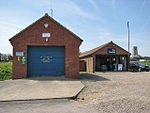 Happisburgh's lifeboat station andRoyal National Lifeboat Institutionshop
 -
 Happisburgh Manor (c.1992)
 -
 The precarious position of houses due to the effects ofcoastal erosion
 -
 Stone tools discovered at Happisburgh


References
[edit]- ^Census population and household counts for unparished urban areas and all parishes.Office for National Statistics & Norfolk County Council (2001). Retrieved 20 June 2009.
- ^Key Statistics: Population.Archived11 February 2003 at theWayback Machine(2011 census) Retrieved 27 February 2015.
- ^Ordnance Survey (2002).OS Explorer Map 252 - Norfolk Coast East.ISBN0-319-21888-0.
- ^Eilert Ekwall,The Concise Oxford Dictionary of English Place-names,p.217.
- ^abParfitt, Simon A.; Ashton, Nick M.; Lewis, Simon G.; Abel, Richard L.; Coope, G. Russell; Field, Mike H.; Gale, Rowena; Hoare, Peter G.; Larkin, Nigel R.; Lewis, Mark D.; Karloukovski, Vassil; Maher, Barbara A.; Peglar, Sylvia M.; Preece, Richard C.; Whittaker, John E. (8 July 2010)."Early Pleistocene human occupation at the edge of the boreal zone in northwest Europe".Nature.466(7303): 229–233.Bibcode:2010Natur.466..229P.doi:10.1038/nature09117.ISSN1476-4687.PMID20613840.
- ^abMiriam Frankel (7 July 2010)."Early Britons could cope with cold: Nature News".Nature.Nature.com.doi:10.1038/news.2010.338.Retrieved13 November2012.
- ^abPallab Ghosh, science correspondent (7 February 2014)."Earliest footprints outside Africa discovered in Norfolk; BBC News".BBC.Retrieved7 February2014.
- ^ab"Coastal erosion at Happisburgh, Norfolk".British Geological Survey.Archived fromthe originalon 6 October 2020.Retrieved4 January2023.
the Norfolk cliffs have been eroding at the present rate for about the last 5000 years, when sea level rose to within a metre or two of its present position
- ^Office for National Statistics & Norfolk County Council (2001).Census population and household counts for unparished urban areas and all parishes.Retrieved 2 December 2005.
- ^"Happisburgh (North Norfolk)".Norfolk Insight.Norfolk County Council.Retrieved12 September2020.
- ^AA Illustrated Guide to Britain,London, 5th edition, 1983, p. 285.
- ^Historic England."Details from listed building database (1169843)".National Heritage List for England.Retrieved1 June2015.
- ^"Happisburgh Lighthouse | Happisburgh Village Website".Archivedfrom the original on 24 October 2016.Retrieved2016-04-13.
- ^abcde"Happisburgh Lifeboat Station".Archived fromthe originalon 7 May 2014.Retrieved7 February2021.
- ^ab"Happisburgh gets set for new lifeboat".North Norfolk News.happisburgh.org. 4 September 2008. Archived fromthe originalon 24 October 2016.
- ^Happisburgh 'Manor' Park / GardenHistoric England."Details from listed building database (1001460)".National Heritage List for England.Retrieved1 June2015.
- ^Historic England."Details from listed building database (1306318)".National Heritage List for England.Retrieved1 June2015.
- ^"HISTORY OF EROSION AND DEFENCES AT HAPPISBURGH".Happisburgh Village Website.Archived fromthe originalon 21 January 2022.Retrieved4 January2023.
Whimpwell, was a parish adjoining Happisburgh The Abbot of St Benets was Lord and patron of the church Destruction its was very rapid. By 1183 only one field remained [...] 1845 A twelve-acre field at Happisburgh was drilled with wheat. A north-west gale raged all night, and by new morning the field had disappeared
- ^"Norfolk surge: Happisburgh house owner's 'stiff upper lip'".BBC News. 12 December 2013.Retrieved21 October2019.
- ^"Happisburgh homes on Norfolk coast to be demolished".BBC News. 10 April 2012.Retrieved21 October2019.
- ^"Climate change: Rising sea levels threaten 200,000 England properties".BBC News.15 June 2022.Retrieved27 August2022.
- ^"Happisburgh Beach Road car park just metres from cliff edge".BBC News.3 December 2023.Retrieved3 December2023.
- ^EU SCI First Northern Europeans[dead link]hosted.ap.org
- ^Ian Sample, science correspondent (7 July 2010)."First humans arrived in Britain 250,000 years earlier than thought | Science".London: Guardian.Retrieved13 November2012.
- ^Briggs, Stacia; Connor, Siofra (20 July 2019)."Weird Norfolk: The terrifying tale of the hump-backed Happisburgh Torso, the ghost whose head trailed behind it".Eastern Daily Press.Retrieved12 September2020.
External links
[edit]- Information from Genuki Norfolkon Happisburgh.
- Village website
- Happisburghfrom the Literary Norfolk website
- A case study of coastal erosion at Happisburghby theBritish Geological Survey
- The earliest humans outside Africaby theBritish Museum's Nicholas Ashton