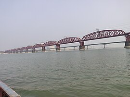
Hardinge Bridge
Hardinge Bridge হার্ডিঞ্জ সেতু | |
|---|---|
 Hardinge Bridge in March 2023 | |
| Coordinates | 24°04′04″N89°01′45″E/ 24.06778°N 89.02917°E |
| Carries | Broad-Gauge Rail-line |
| Crosses | Padma River |
| Locale | Pabna District&Kushtia District,Bangladesh |
| Characteristics | |
| Design | Truss bridge |
| Total length | 1,798.32 m (5,900 ft) |
| History | |
| Designer | A M Rendel[1] |
| Constructed by | Braithwaite and Kirk[1] |
| Opened | 4 March 1915 |
| Location | |
 | |
| Part of a series on |
| Transport in Bangladesh |
|---|
 |
| Modes |
| Aviation |
| Authorities |
|
| Public transits |
| Important infrastructures |
| Others |
Hardinge Bridgeis asteelrailwaytruss bridgeover thePadma Riverlocated atIshwardi,PabnaandBheramara,andKushtiainBangladesh.It is named afterLord Hardinge,who was theViceroyofIndiafrom 1910 to 1916. The bridge is 1.8 km (1.1 mi) long.[2]
Construction
[edit]Construction of thethrough trussbridge began in 1910,[2]though it was proposed at least 20 years earlier. It was constructed by Braithwaite and Kirk Company based on design of SirAlexander Meadows Rendel.[1]It was completed in 1912,[2]and trains started moving on it in 1915.[3]
Brief history
[edit]

The construction of a railway bridge over the Padma was proposed in 1889 by the Eastern Bengal Railway for easier communication betweenCalcuttaand the thenEastern BengalandAssam.In 1902, Sir FJE Spring prepared a report on the bridge. A technical committee reported that a bridge could be constructed at Sara crossing the lowerGangesbetween the Paksey andBheramara Upazilastations on the broad gauge railway fromKhulnatoParbatipur Upazila.The construction of the bridge started in 1910 and finished two years later.[4]The bridge comprises 15 steel trusses. The main girders are modified "Petit" type.
The most difficult task of the operation was to prevent bank erosion and to make the river flow permanently under the bridge. For this, two guide banks of the "Bell-bund"type named after J. R. Bell were built on either side, each extending 910 metres (3,000 ft) upstream and 300 metres (1,000 ft) downstream from the bridge.[3]The ends of the river banks were curved inward and heavily pitched with stone.[3]
Hardinge Bridge was severely damaged during theLiberation War of Bangladeshof 1971. It happened on 13 December 1971, when theIndian Air Forceplane bombed on the 4th guarder from the Paksey side. As thePakistani armywas on retreat towardsJessore(their last stronghold) Hardinge Bridge was strategically very important. The allied force damaged the bridge. TheJapaneseGovernment helped to reconstruct the bridge.[citation needed]
It is the second largest railway bridge inBangladesh.Another bridge namedLalon Shah Bridgefor road transport beside the Hardinge Bridge has recently been constructed.[citation needed]
Gallery
[edit]References
[edit]- ^abc"Braithwaite and Kirk".Grace's Guide.Retrieved15 August2015.
- ^abc"Hardinge Bridge".Structurae.Wilhelm Ernst and Sohn Verlag. 29 July 2014.Retrieved17 October2014.
- ^abcColeman, F. C. (17 June 1915)."Hardinge Bridge Over the Lower Ganges in India".Engineering News.73(24): 1160–64.Retrieved17 October2014.
- ^"News and more information".Archived fromthe originalon 30 November 2004.Retrieved2 December2006.
External links
[edit]- Hardinge Bridgein Banglapedia


