Hazel Brook
| Hazel Brook Hen | |
|---|---|
 River Trymand Hazel Brook inBristol,England | |
| Location | |
| Country | England |
| District | South Gloucestershire |
| Municipality | Bristol |
| Physical characteristics | |
| Source | Cribbs Causeway |
| • location | South Gloucestershire,West of England,England |
| • coordinates | 51°31′30″N2°36′47″W/ 51.525°N 2.613°W |
| • elevation | 263 ft (80 m) |
| Mouth | Coombe Dingle |
• location | Bristol,West of England,England |
• coordinates | 51°29′42″N2°38′28″W/ 51.495°N 2.641°W |
• elevation | 195 ft (59 m) |
| Length | 2 mi (3.2 km) |
| Basin features | |
| River system | Bristol Avon |
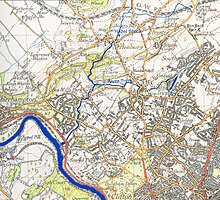
TheHazel Brook,also known as theHen,[1][2]is a tributary of theRiver TryminBristol,England.It rises atCribbs CausewayinSouth Gloucestershire.From there, its course takes it south, passing the western end ofFilton Aerodromeon its left bank, throughBrentryandHenburybefore dropping through a steep limestone gorge in theBlaise Castleestate. It continues south through two lakes before joining the Trym atCoombe Dingle.[3][4]
Hydrology
[edit]Surface run-off in the upper catchment of the Hazel Brook, especially from the large retail centre atCribbs Causeway,sends a good deal of silt into the system, slowing the flow and creating a risk of flooding downstream in the Trym. This problem has now been partially alleviated by the construction of theCatbrainattenuation reservoir near Cribbs Causeway.[5]Measurements of pollution by the city council show the water to be relatively clean.[6][7]
References
[edit]- ^"The Big Blue Map of Bristol".Bristol City Council.Retrieved29 August2018.
- ^"The river Hen and Hazel Brook".The Name of the Green Dragon.Retrieved29 August2018.
- ^Plaster, Andrew."Henbury".Bristol & Avon Family History Society.Retrieved29 August2018.
- ^"Visit to the South-West, Thursday 13th/Friday 14th January 2000".Parliament.Retrieved29 August2018.
- ^ "Waterways Monitoring: River Trym and Hazel Brook".Bristol City Council. Archived fromthe originalon 20 May 2011.Retrieved24 November2009.
- ^"Rivers and Rhines".Bristol City Council.Retrieved29 August2018.
- ^"Trym - source to conf R Avon (Brist)".Environment Agency.Retrieved29 August2018.
