
Heukelum
Heukelum | |
|---|---|
Small city | |
 Former town hall | |
 Flag  Coat of arms | |
 Heukelum Location in the province of Gelderland in the Netherlands  Heukelum Heukelum (Netherlands) | |
| Coordinates:51°52′23″N5°4′36″E/ 51.87306°N 5.07667°E | |
| Country | Netherlands |
| Province | Gelderland |
| Municipality | West Betuwe |
| Area | |
| • Total | 3.62 km2(1.40 sq mi) |
| Elevation | 1.8 m (5.9 ft) |
| Population (2021)[1] | |
| • Total | 2,280 |
| • Density | 630/km2(1,600/sq mi) |
| Time zone | UTC+1(CET) |
| • Summer (DST) | UTC+2(CEST) |
| Postal code | 4161[1] |
| Dialing code | 0345 |
Heukelumis a city in theDutchprovince ofGelderland.It is a part of the municipality ofWest Betuwe,and lies about 8 km northeast ofGorinchem.It receivedcity rightsin 1391.
History
[edit]It was first mentioned in 996 as Ukele, and means "settlement on the height".[3]Heukelum is an elongatedesdorpwhich developed on the river bank of theLingein the Early Middle Ages.[4]
The Dutch Reformed church developed in stages between 1350 and 1510 to replace its predecessor from around 1250. The tower and nave were destroyed by fire in 1699.[4]Part of the defensive works around the city from the 16th and 17th century are still present.[4]
Heukelum Castle (also Merckenburg Castle) was originally built before 1286 by the van Arkel family as one of nine castles to defend theLand van Arkelagainst Holland and Gelderland. It is the only castle which remained after theArkel War(1401-1412). In 1672, it was severely damaged by the French. The castle changed ownership several times, but is still private property.[5]
Heukelum was flooded many times during its history. The last times were in 1939 and 1945 when the area around Heelsum was inundated to thwart the advance of the German and Allied armies respectively.[6]
Heukelum was home to 535 people in 1840.[6]Heukelum was a separate municipality until 1986, when it became part ofVuren.The area was part ofSouth Hollanduntil then, and is now part ofGelderland.[7]
Gallery
[edit]-
 Former forge
 -
 Dutch Reformed church
 -
 Heukelum Castle
 -
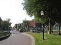 Street view


References
[edit]- ^abc"Kerncijfers wijken en buurten 2021".Central Bureau of Statistics.Retrieved14 April2022.
three entries; includes the hamlet Friezenwijk
- ^"Postcodetool for 4161AA".Actueel Hoogtebestand Nederland(in Dutch). Het Waterschapshuis.Retrieved14 April2022.
- ^"Heukelum - (geografische naam)".Etymologiebank(in Dutch).Retrieved14 April2022.
- ^abcRonald Stenvert & Sabine Broekhoven (2000)."Heukelum"(in Dutch). Zwolle: Waanders.ISBN90 400 9406 3.Retrieved14 April2022.
- ^"Burcht Merckenburg in Heukelum".Mijn Gelderland(in Dutch).Retrieved14 April2022.
- ^ab"Heukelum".Plaatsengids(in Dutch).Retrieved14 April2022.
- ^Ad van der Meer and Onno Boonstra,Repertorium van Nederlandse gemeenten,KNAW, 2011.
| National | |
|---|---|
| Geographic | |