
History of the Yosemite area

| History ofCalifornia |
|---|
 |
| Periods |
| Topics |
| Cities |
| Regions |
| Bibliographies |
|
|
Human habitation in theSierra Nevadaregion of California reaches back 8,000 to 10,000 years ago.[1]Historically attestedNative Americanpopulations, such as theSierra Miwok,MonoandPaiute,belong to theUto-AztecanandUtianphyla. In the mid-19th century, a band of Native Americans called theAhwahnecheelived inYosemite Valley.TheCalifornia Gold Rushgreatly increased the number of non-indigenous people in the region. Tensions between Native Americans andwhite settlersescalated into theMariposa War.As part of this conflict, settler James Savage led theMariposa Battalioninto Yosemite Valley in 1851, in pursuit of Ahwaneechees led byChief Tenaya.The California state military forces burned the tribe's villages, destroyed their food stores, killed the chief's sons, and forced the tribe out of Yosemite. Accounts from the Mariposa Battalion, especially from Dr.Lafayette Bunnell,popularized Yosemite Valley as a scenic wonder.
In 1864, Yosemite Valley and theMariposa Groveofgiant sequoiatrees were transferred from federal to state ownership. Yosemite pioneerGalen Clarkbecame the park's first white guardian. Conditions in Yosemite Valley were made more hospitable to non-indigenous people, and access to the park was improved in the late 19th century. Indigenous people continued to be forced out periodically, while white settlers were paid a total of $60,000 to move out of the valley. NaturalistJohn Muirand others became increasingly alarmed about the excessive exploitation of the area. Their efforts helped establish Yosemite National Park in 1890. Yosemite Valley and the Mariposa Grove were added to the national park in 1906.
TheUnited States Armyhad jurisdiction over the national park from 1891 to 1914, followed by a brief period of civilian stewardship. The newly formedNational Park Servicetook over the park's administration in 1916. Improvements to the park helped to increase visitation during this time. Preservationists led by Muir and theSierra Clubfailed to saveHetch Hetchy Valleyfrom becoming a reservoir when the Raker Act was approved on December 2, 1913. This event was considered a major conservation battle lost, after which John Muir gave up on fighting and died on December 24, 1914. Construction on the O'Shaughnessey Dam began in 1919 and was completed in 1923. The loss of Hetch Hetchy led to the formation of the National Park Service through the approval of the Organic Act of 1916. In 1964, 89 percent of the park was set aside in a highly protectedwilderness area,and other protected areas were added adjacent to the park. The once-famousYosemite Firefall,created by pushing red hot embers off a cliff nearGlacier Pointat night, was discontinued in the mid-to-late 20th century along with other activities that were deemed to be inconsistent with protection of the national park (bear feeding had already been discontinued in 1940).
Early history[edit]
Native Americans[edit]
Humans may have lived in the Yosemite area as long as 8,000 to 10,000 years ago.[1] Habitation of theYosemite Valleyproper can be traced to about 3,000 years ago, when vegetation and game in the region was similar to that present today; the western slopes of the Sierra Nevada had acorns, deer, and salmon, while the eastern Sierra had pinyon nuts andobsidian.[2]Native Americangroups traveled between these two regions to trade and raid.

Archaeologists divide the pre-European American contact period of the region into three cultural phases. The Crane Flat phase lasted from 1000 BCE to 500 CE and is marked by hunting with theatl atland the use ofgrinding stones.[4]The Tarmarack phase lasted from 500 until 1200, marked by a shift to using smaller rock points, indicating development and use of thebow and arrow.[4]The Mariposa phase lasted from 1200 until contact with European Americans.[4]
Trade between tribes became more widespread during the Mariposa phase, and the diet continued to improve.Paiutes,Miwok,andMonosvisited the area to trade; one major trading route went overMono Passand throughBloody CanyontoMono Lakein Eastern California.[5]
Paiuteswere the primary inhabitants of the Yosemite area and the foothills to the east during the Mariposa and historic phases.[6]The Central Sierra Miwoks lived along the drainage area of theTuolumneandStanislaus Rivers,while the Paiutes inhabited the upper drainage of theMercedandChowchilla Rivers.[6]
The Paiutes of Yosemite Valley called themselves theAh-wah-ne-chee,meaning "dwellers in Ahwahnee."[7]The Ahwahneechees were decimated by a disease in about 1800, and left the valley, although about 200 returned under the leadership ofTenaya,son of an Ahwahneechee chief.[7]
Displaced Native Americans from the Californian coast moved to the Sierra Nevada during the early-to-mid-19th century, bringing with them their knowledge ofSpanish food,technology, and clothing. Joining forces with the other tribes in the area, they raidedland grant ranchoson the coast and drove herds of horses to the Sierra, where horse meat became a major new food source.
Exploration by European Americans[edit]
Although there wereSpanish missions,pueblos(towns),presidios(forts), andranchosalong the coast of California, no Spanish explorers visited the Sierra Nevada.[4]The first European Americans to visit the mountains were amongst a group led by fur trapperJedediah Smith,crossing north of the Yosemite area in May 1827, atEbbetts Pass.[4]

A group of trappers led by mountain manJoseph Reddeford Walkermay have seen Yosemite Valley in the autumn of 1833.[8]Walker approached a valley rim as he led his party across the Sierra Nevada, but he did not enter it. A member of the group, Zenas Leonard, wrote in his journal that streams from the valley rim dropped "from one lofty precipice to another, until they are exhausted in rain below. Some of these precipices appeared to us to be more than a mile high."[9]The Walker party probably visited either theTuolumneorMerced Grovesofgiant sequoia,becoming the first non-indigenous people to see the giant trees,[9]but journals relating to the Walker party were destroyed in 1839, in a print shop fire in Philadelphia.[10]
The part of the Sierra Nevada where the park is located was long considered to be a physical barrier to European American settlers, traders, trappers, and travelers. That situation changed in 1848 after gold was discovered in the foothills west of the range.[10]Travel and trade activity dramatically increased in the area during the ensuingCalifornia Gold Rush.Resources depended upon by local Native Americans were depleted or destroyed, and disease brought by the newcomers spread rapidly through indigenous populations. Extermination of native culture became a policy of the United States Government.[11]
The first confirmed sighting of Yosemite Valley by a non-indigenous person occurred on October 18, 1849, by William P. Abrams and a companion.[12]Abrams accurately described some landmarks, but it is uncertain whether he or his companion actually entered the valley. In 1850, one of three brothers, Joseph, William, or Nathan Screech, became the first confirmed non-indigenous person to enterHetch Hetchy Valley.[13]Joseph Screech returned two years later and spoke with the Native Americans living there, asking them what the name of a grass-covered seed meal was and was told, "hatch hatchy."[13]
The surveying crew of Allexey W. Von Schmidt conducted the first systematic traverse of any part of the Yosemite area backcountry in 1855, when it extended an approximation of the Mount Diablo Baseline eastward from a point west of the present park boundary, to a point south of Mono Lake. The actual route taken was 5 to 6 miles south of the actual baseline, due to topographic difficulties, including the Tuolumne River canyon at low elevations, and steep mountain slopes higher up. Nevertheless, this was the first straight line survey made across the Sierra Nevada[14]From 1879 to 1883 large parts of the western half of the park were surveyed as part of the General Land Office survey. However, the individual contracted for the largest area, one S. A. Hanson, was later listed among those associated with theBenson Syndicate,and he combined actual with probably fabricated surveys. Topographic surveys performed by LieutenantMontgomery M. Macomb,[15]under George M Wheeler'sSurveys West of the 100th Meridian,were completed in the late 1870s and early 1880s.[16]
Mariposa Wars[edit]

James Savage's trading camp on theMerced River,10 miles (16 km) west of Yosemite Valley,[11]was raided by Native Americans in December 1850, after which the raiders retreated into the mountains.[11] The camp had been founded because theCalifornia Gold Rushhad begun in 1849 bringing more than 40,000 gold seekers down theCalifornia Trailinto northern and central California. This rapid influx of non-native settlers precipitated theCalifornia genocideof the indigenous peoples in the State.[17]Before 1849, much of Northern and Central California had been populated by Native Americans andCalifornios(the descendants of earlySpanish settlers). However by 1873, almost 80 percent of California's Native American population had been wiped out by conflict and disease, and their historic land seized by settlers fromMexico,South America,Europe,Australia,andChina.[17]
In response to miners forcing Native Americans off their historic lands in search for gold, Native Americans launched punitive raids against camps and settlements. Some tribes were pressed into service in mines; others had their villages raided by the army and volunteer militias. Some white settlers also thought it was time to get rid of Native Americans because they commanded too much labor in the mines.[17]In retaliation for the attack on his camp, a month later in January 1851, Jim Savage led a militia in a punitive action against a native village, but after opening fire they were beaten back by indigenous firepower.[17]Savage appealed toJohn McDougal,governor of Californiato raise a formation to sort the "Indian problem" out once and for all.[18][19]The subsequent campaigns led by theMariposa Battalionin 1851 became known as theMariposa War.[20]
Savage led the battalion into Yosemite Valley in 1851, in pursuit of around 200 Ahwaneechees led by Chief Tenaya.[21]On March 27, 1851, the company of 50 to 60 men reached what is now called Old Inspiration Point, from where Yosemite Valley's main features are visible.[8]Chief Tenaya and his band were eventually captured and their village burned, fulfilling the prophecy an old and dyingmedicine manhad given Tenaya many years before.[22]The Ahwahnechee were marched from their tribal lands under armed guards led by Captain John Bowling, to theFresno River Reservation.With the fighting ended, the battalion was disbanded on July 1, 1851.[23]
Life on the reservation was unpleasant and the Ahwahneechee longed to return to the Yosemite area. Reservation officials consented and allowed Tenaya and some of his band to return to their lands.[23]However, in May 1852 a group of eight armed miners entered Yosemite Valley and were allegedly attacked by Tenaya's warriors; two of the miners were killed.[23]In retaliation regular army troops under the direction of Lt. Tredwell Moore shot dead six Ahwahneechee who were in possession of European clothing.[23]
Tenaya's band fled the valley and sought refuge with theMono people,his mother's tribe. A year later, in mid-1853, the Ahwahneechee returned to the valley but they betrayed the hospitality of their former Mono hosts by stealing horses that the Mono had taken from non-indigenous ranchers.[22]In return, the Monos tracked down and killed many of the remaining Ahwahneechee, including Tenaya (Tenaya Lakeis named after the fallen chief). Inter-tribal hostilities eventually subsided and by the mid-1850s local European American residents started to befriend Native Americans still living in the Yosemite area.
Naming the area[edit]

During the military campaigns of the Mariposa War, members of the Mariposa Battalion had proposed names for the valley while they were camped at Bridalveil Meadow. The company physician who had been attached to Savage's unit, Dr.Lafayette Bunnell,suggested "Yo-sem-i-ty". It was the name that the surrounding Sierra Miwok peoples used, as they feared the tribes in the Yosemite Valley.[24]Savage, who spoke some native dialects, translated this as "full-grown grizzly bear."[24]The term, which was possibly derived from or confused with the similaruzumatioruhumati,meaning "grizzly bear," is the Southern Sierra Miwok wordYohhe'meti,meaning "they are killers."[25][26]Bunnell named many other local topographic features on the same trip.
Bunnell drafted an article about the trip, but destroyed it when a newspaper correspondent inSan Franciscosuggested cutting his 1,500- foot (460 m) height estimate for the valley's walls in half; the walls are in fact twice the height that Bunnell surmised.[22]The first published account of Yosemite Valley was written by Lt. Tredwell Moore for the January 20, 1854, issue of theMariposa Chronicle,[8]establishing the modern spelling ofYosemite.Bunnell described his awestruck impressions of the valley in his book,The Discovery of the Yosemite,published in 1892.[27]
Artists, photographers, and the first tourists[edit]


Forty-eight Non-Indian people visited Yosemite Valley in 1855, including San Francisco writerJames Mason Hutchingsand artistThomas Ayres.[28]Hutchings wrote an article about his experience that was published in the July 12, 1855, issue of theMariposa Gazetteand Ayres' sketch ofYosemite Fallswas published in late 1855; four of his drawings were presented in the lead article of the July 1856 and initial issue ofHutchings' Illustrated California Magazine.[29]The article and illustrations created tourist interest in Yosemite and eventually led to its protection.[30]
Ayres returned in 1856 and visitedTuolumne Meadowsin the area's high country.[21]His highly detailed angularly exaggerated artwork and his written accounts were distributed nationally and an art exhibition of his drawings was held in New York City.
Hutchings took photographerCharles Leander Weedto Yosemite Valley in 1859; Weed took the first photographs of the valley's features, which were presented to the public in a September exhibition held in San Francisco.[21]Hutchings published four installments of "The Great Yo-semite Valley" from October 1859 to March 1860 in his magazine and re-published a collection of these articles in hisScenes of Wonder and Curiosity in California,which remained in print into the 1870s.[29][31]

Carleton Watkinsexhibited his 17 by 22 in (43 by 56 cm) Yosemite views at the1867 Paris International Exposition.[32]
PhotographerAnsel Adamsmade his first trip to Yosemite in 1916; his photographs of the valley made him famous in the 1920s and 1930s.[7]Adams willed the originals of his Yosemite photos to the Yosemite Park Association, and visitors can still buy direct prints from his original negatives. The studio in which the prints are sold was established in 1902 by artistHarry Cassie Best.[33]
Milton and Houston Mann opened a toll road to Yosemite Valley in 1856, up the South Fork of the Merced River.[29]They charged the then considerable sum of twodollarsper person until the road was bought byMariposa County,after which it became free.
In 1856, settlerGalen Clarkdiscovered theMariposa Groveof giant sequoia atWawona,an indigenous encampment in what is now the southwestern part of the park.[29]Clark completed a bridge over the South Fork of the Merced River in 1857 at Wawona for traffic headed toward Yosemite Valley and provided a way station for travelers on the road the Mann brothers built to the valley.[34]
Simple lodgings, later called the Lower Hotel, were completed soon afterward; the Upper Hotel, later renamed Hutchings House and eventually known asCedar Cottage,was opened in 1859.[35]In 1876, the more substantialWawona Hotelwas built to serve tourists visiting the nearby grove of big trees and those on their way to Yosemite Valley.[36]Aaron Harris opened the first campground business in Yosemite in 1876.[37]
State grant[edit]
Forming the state grant[edit]

Visitation and interest in Yosemite continued to grow through theAmerican Civil War.UnitarianministerThomas Starr Kingvisited the valley in 1860 and saw some of the negative effects that settlement and commercial activity were having on the area.[35]Six travel letters by Starr King were published in theBoston Evening Transcriptin 1860 and 1861; Starr King became the first person with a nationally recognized voice to call for a public park at Yosemite.[38]Oliver Wendell HolmesandJohn Greenleaf Whittierread and commented on Starr King's letters and landscape architectFrederick Law Olmstedwas prompted by the warnings to visit the Yosemite area in 1863.[38][35]
Pressure from Starr King and Olmsted, photographs byCarleton Watkins,and geological data from the 1863Geological Survey of Californiaprompted legislators to take action. SenatorJohn Connessof California introduced a park bill in 1864 to theUnited States Senateto cede Yosemite Valley and the Mariposa Grove of Big Trees to California.[39]
The bill easily passed both houses of theUnited States Congress,and was signed by PresidentAbraham Lincolnon June 30, 1864.[35]The Yosemite Grant, as it was called, was given to California as a state park for "public use, resort and recreation".[40]A board of commissioners, with Frederick Law Olmsted as chairman, was formed in September 1864 to govern the grant, but it did not meet until 1866.[35]
Managing the state grant[edit]
The commission appointed Galen Clark as the grant's first guardian, but neither Clark nor the commissioners had the authority to evicthomesteaders.Josiah Whitney,the first director of the California Geological Survey, lamented that Yosemite Valley would meet the same fate asNiagara Falls,which at that time was atourist trapwith tolls on every bridge, path, trail, and viewpoint.[41]

Hutchings and a small group of settlers sought legal homesteading rights on 160 acres (65 ha) of the valley floor.[42]The issue was not settled until 1874 when the land holdings of Hutchings and three others were invalidated and the state legislature appropriated $60,000 ($1,620,000 as of 2024) to compensate the settlers, of which Hutchings received $20,000.[43]
Conditions in Yosemite Valley and access to the park steadily improved. In 1878, Clark used dynamite to breach a recessionalmorainein the valley to drain a swamp behind it.[21]Tourism significantly increased after aSacramentotoStocktonextension of theFirst transcontinental railroadwas completed in 1869 and theCentral Pacific RailroadreachedMercedin 1872.[44]
The long horseback ride from Merced remained a deterrent to tourists. Threestagecoachroads were built in the mid-1870s to provide better access; Coulterville Road (June 1874), Big Oak Flat Road (July 1874), and the Wawona Road (July 1875).[45]A road toGlacier Pointwas completed in 1882 by John Conway, and the Great Sierra Wagon Road was opened in 1883, which roughly followed the Mono Trail to Tuolumne Meadows.[46]
Clark and the sitting commissioners were removed from office by the California Legislature in 1880, and Hutchings became the new guardian.[45]Hutchings in turn was replaced as guardian, in 1884, byW. E. Dennison.[47]Clark was reappointed as guardian in 1889 and retired in 1896.[48]
In 1900, Oliver Lippincott became the first to drive an automobile into Yosemite Valley.[49]Yosemite Valley Railroad,nicknamed "the short line to paradise," arrived at nearbyEl Portal, Californiain 1907.[50]Numerous hiking and horse trails were cleared, including a walking path through Mariposa Grove.
Concessionaires[edit]

Yosemite's first concession was established in 1884 when Mr. and Mrs. John Degnan established a bakery and store.[51]The Desmond Park Service Company was granted a twenty-year concession in 1916; the company bought out or built hotels, stores, camps, a dairy, a garage, and other park services.[52]Desmond changed its name to the Yosemite National Park Company in December 1917 and was reorganized in 1920.[53]
The Curry Company was started by David and Jenny Curry in 1899; the couple also founded Camp Curry, now known asCurry Village.[54]The Currys lobbied reluctant park supervisors to allow expansion of concessionaire operations and development in the area.
Administrators in the National Park Service felt that limiting the number of concessionaires in each national park would be more financially sound. The Curry Company and its rival, the Yosemite National Park Company, were forced to merge in 1925 to form theYosemite Park & Curry Company(YP&CC).[55]
National park[edit]
John Muir's influence[edit]
Immediately following his arrival in California in March 1868, naturalistJohn Muirset out for the Yosemite area,[56]where he found work tending to the sheep owned by a local rancher, Pat Delaney. Muir's employment provided him with the opportunity to study the area's plants, rocks, and animals;[56]the articles and scientific papers he wrote describing his observations helped to popularize the area and to increase scientific interest in it. Muir was one of the first to suggest that Yosemite Valley's major landforms were created by large alpine glaciers, contradicting the view of established scientists such as Josiah Whitney, who regarded Muir as an amateur.[42]
Alarmed by over grazing of meadows, logging of giant sequoia, and other damage, Muir changed from being a promoter and scientist to an advocate for further protection.[57]He persuaded many influential people to camp with him in the area, such asRalph Waldo Emersonin 1871.[58]Muir tried to convince his guests that the entire area should be under federal protection. None of his guests through the 1880s could do much for Muir's cause, except forRobert Underwood Johnson,editor ofCentury Magazine.Through Johnson, Muir had a national audience for his writing and a highly motivated and crafty congressional lobbyist.[59]
Muir's wish was partially granted on October 1, 1890, when the area outside the valley and sequoia grove became anational parkunder the unopposed Yosemite Act.[60]The Act provided "for the preservation from injury of all timber, mineral deposits, natural curiosities, or wonders within said reservation, and their retention in their natural condition" and prohibited "wanton destruction of the fish and game and their capture or destruction for the purposes of merchandise or profit."[61]
Yosemite National Park included the entire upper drainages of two riverwatersheds.Preservation of watersheds was very important to Muir, who said "you cannot save Yosemite Valley without saving its Sierran fountains."[32]The State of California retained control of Yosemite Valley and the Mariposa Grove of Big Trees. Muir and 181 others founded theSierra Clubin 1892, in part to lobby for the transfer of the valley and the grove into the national park.[51]
Army administration[edit]
LikeYellowstone National Parkbefore it, Yosemite National Park was at first administered by various units of theUnited States Army.CaptainAbram Woodled the4th Cavalry Regimentinto the new park on May 19, 1891, and set up Camp A.E. Wood (now the Wawona Campground) in Wawona.[62]Each summer, 150 cavalrymen traveled from thePresidio of San Franciscoto patrol the park. Approximately 100,000 sheep were illegally led into Yosemite's high meadows each year.[59]The Army lacked legal authority to arrest the herders, but instead escorted them several days' hike from their flock, which left the sheep vulnerable. By the late 1890s sheep grazing was no longer a problem, but at least one herder continued to graze his sheep in the park into the 1920s.[63]
The Army also tried to control poaching. In 1896, acting Superintendent Colonel S. B. M. Young stopped issuing firearm permits after discovering that large numbers of game and fish were being killed.[64]Poaching continues to be an issue in the 21st century.[65]The Army's administration of the park ended in 1914.[66]
Galen Clark retired as the state grant's guardian in 1896, leaving Yosemite Valley and the Mariposa Grove of Big Trees under ineffective stewardship.[63]Pre-existing problems in the state grant worsened and new problems arose, but the cavalry could only monitor the situation. Muir and the Sierra Club continued to lobby the government and influential people for the creation of a unified Yosemite National Park. The Sierra Club began to organize annual trips to Yosemite in 1901 in an effort to make the remote area more accessible.[67]
Unified national park[edit]

U.S. PresidentTheodore Rooseveltcamped with John Muir nearGlacier Pointfor three days in May 1903.[68]During that trip, Muir convinced Roosevelt to take control of the valley and the grove away from California and give it to the federal government. On June 11, 1906, Roosevelt signed a bill that did precisely that, and the superintendent's headquarters was moved from Wawona to Yosemite Valley.[69]
To secure congressional and State of California approval for the plan, the size of the park was reduced by more than 500 square miles (1,300 km2),[70]which excluded natural wonders such as theDevils Postpileand prime wildlife habitat. The park was again reduced in size in 1906, when logging began in an area around Wawona.[71]Acting superintendent Major H. C. Benson said in 1908 that "game is on the decrease. Each reduction of the park has cut another portion of the winter resort of game."[71]The various changes meant that the park was reduced to two-thirds of its original size.[71]
About 12,000 acres (4,900 ha) between the Tuolumne and the Merced big tree groves were added to the park in 1930 through land purchases by the federal government and matching funds provided by industrialistJohn D. Rockefeller.[71]Another 8,765 acres (3,547 ha) near Wawona were added in 1932. The Carl Inn Tract, close to the Rockefeller purchase, was secured in 1937 and 1939.[71]
Fight over Hetch Hetchy Valley[edit]
San Francisco MayorJames D. Phelanhired USGS engineer Joseph P. Lippincott in 1900 to perform a discreet survey ofHetch Hetchy Valley,located north of Yosemite Valley in the national park.[72]His report stated that a dam of theTuolumne Riverin the Hetch Hetchy Valley was the best choice to create a drinking water reservoir for the city. Lippincott soughtwater rightsto the Tuolumne River and rights to build reservoirs at Hetch Hetchy andLake Eleanoron behalf of Phelan in 1901.[72]These requests were rejected in 1903 by Secretary of the InteriorEthan Allen Hitchcock,who felt the application was "not in keeping with the public interest."[71]

The1906 San Francisco earthquaketipped the balance in favor of granting the city the right to build the dam. Rights to Hetch Hetchy were granted to the City of San Francisco in 1908 by Secretary of the InteriorJames Rudolph Garfield,who wrote: "Domestic use is the highest use to which water and available storage basins... can be put."[71]
A nationally publicized fight over the dam project ensued; preservationists like Muir wanted to leave wild areas wild, and conservationists likeGifford Pinchotwanted to manage wild areas for the betterment of mankind. Robert Underwood Johnson and the Sierra Club joined the fight to save the valley from flooding. Muir wrote, "Dam Hetch Hetchy! As well dam for watertanks the people's cathedrals and churches, for no holier temple has ever been consecrated by the heart of man."[73]Pinchot, who was director of theU.S. Forest Service,wrote to his close friend Roosevelt that "the highest possible use which could be made of it would be to supply pure water to a great center of population."[73]
Roosevelt's successor,Woodrow Wilson,signed theRaker Actinto law on December 13, 1913, which authorized construction of the dam.[63][74]Hetch Hetchy Reservoirgrew as the valley was flooded behind theO'Shaughnessy Damin 1923.[58]The Raker Act also gave the city the right to store water in Lake Eleanor and Cherry Lake, both located northwest of Hetch Hetchy in the park.[75]
Shortly before Muir died he expressed the hope that "some compensating good must follow" from the Raker Act.[76]The fight over the dam strengthened the conservation movement by popularizing it nationally.
National Park Service[edit]
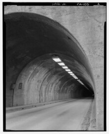
The administration of Yosemite National Park was transferred to the newly formedNational Park Servicein 1916, whenW. B. Lewiswas appointed as the park's superintendent.Parsons Memorial LodgeandTioga Pass Road,along with campgrounds at Tenaya and Merced lakes, were completed the same year; six hundred automobiles entered the east side of the park using Tioga Road that summer.[76]The "All-Weather Highway" (nowState Route 140) opened in 1926, ensuring year-long visitation and delivery of supplies under normal conditions.[77] Completion of the 0.8-mile (1.3 km)-longWawona Tunnelin 1933 significantly reduced travel time to Yosemite Valley from Wawona.[78]The famous Tunnel View is on the valley side of the tunnel and Old Inspiration Point is above it. A flood, reduced lumber and mining extraction, and greatly increased automobile and bus use forced the Yosemite Valley Railway out of business in 1945.[79]The present day Tioga Road, now part ofCalifornia State Route 120,was dedicated in 1961.[80]

Interpretive programs and services for national parks were pioneered in Yosemite by Harold C. Bryant andLoye Holmes Millerin 1920.[81]Ansel F. Hall became the first park naturalist in 1921 and served in that role for two years.[82]Hall's idea to have park museums act as public contact centers for interpretive programs became a model followed by other national parks in the United States and internationally.Yosemite Museum,the first permanent museum in the National Park System, was completed in 1926.[83]
TheAhwahnee Hotel,in Yosemite Valley, is aNational Historic Landmark.Built in 1927,[84]it is a luxury hotel designed by the architectGilbert Stanley Underwood,decorated in Native American motifs.[84]For many years it hosted an annual pageant produced by Ansel Adams. During World War II it was used as a rehabilitation hospital for soldiers.
Restoration and preservation[edit]
Large floods covered Yosemite Valley in 1937, 1950, 1955, and 1997.[85]These floods had a flow rate of 22,000 to 25,000 cubic feet (620 to 700 m3) per second, as measured at the Pohono Bridge gauging station in Yosemite Valley.[85]
All the structures in Old Yosemite Village, except for the chapel, were either moved to the Pioneer Yosemite History center in Wawona or demolished during the 1950s and 1960s.[86]Other structures in the park were also moved to the history center. Cedar Cottage, the oldest building in Yosemite Valley, was demolished in 1941 along with others, even though they had not been flooded.[87]Little regard was given to historic preservation, as the priority was thought to be the preservation and restoration of natural scenery.[88]
Congress set aside about 89 percent of the park in a highly protectedwilderness areathrough passage of theWilderness Actof 1964.[89]No roads, motorized vehicles (except rescue helicopters and other emergency vehicles), or any development beyond trail maintenance are allowed in this area. The adjacentAnsel Adams WildernessandJohn Muir Wildernesswere also protected under the act and include regions removed from the park immediately before it was unified with the state grant in 1906.[90][91]
TheYosemite Firefall,in which the embers from a bonfire were pushed off a cliff near Glacier Point to create a spectacular effect, was ended in 1968 because it was deemed to be inconsistent with park values.[92]The firefall was occasionally performed in the 1870s and became a nightly tradition with the founding of Camp Curry.[93]
Since the late 1960s[edit]
Broader tensions in American society surfaced in Yosemite when a large number of youths gathered in the park over the summer of 1970, triggering a riot on July 4 after rangers tried to evict visitors from camping illegally in Stoneman Meadow.[94]Rioters attacked the rangers with rocks, and pulled mounted rangers from their horses. TheNational Guardwas brought in to restore order.
The Yosemite Park and Curry Company was bought byMusic Corporation of America(MCA) in 1973.[95]In 1988, concessionaires brought in $500 million ($1.29 billion as of 2024), and paid the federal government $12.5 million ($32.2 million as of 2024) for the franchise.[96]Delaware North Companiesbecame the primary concessionaire for Yosemite in 1992. The agreement it signed with the National Park Service increased yearly park revenue from concessionaires to $20 million ($43.4 million as of 2024).[97]The current concessionaire is Aramark.
In 1999, four women were killed byCary Staynerjust outside the park.[98]That same year a large rockslide originating at the east side of Glacier Point ended near theHappy Islesof the Merced River, creating a debris field larger than several football fields.[99]Tourism dropped a little after those incidents, but soon returned to its previous level.
Transportation[edit]
The Stagecoach Era[edit]

For the initial twenty-three years following Savage's arrival in Yosemite, rugged horse trails served as the solitary access points to Yosemite Valley. These challenging routes, carved into the mountainous terrain, were traversed by an estimated twelve thousand adventurous visitors.[100][101]: 7–8

In 1859, the Yosemite Turnpike Company pioneered wheeled vehicle access to Yosemite. They initially constructed a stage road up to Crane Flat, a distance of sixteen miles from the valley. After negotiating with Yosemite commissioners, they secured the rights to build and operate a toll road into the valley, enjoying a ten-year exclusivity period along the route. This agreement led to the commencement of the Coulterville Road construction in 1870, which they completed on June 17, 1874.[102][100]Two other competing routes, theBig Oak Flat Road(July 1874)[103]and the Wawona Road (1875),[104]quickly followed.[105]
The completion of thefirst transcontinental railroad,along with the extension ofCentral Pacific Railroadservices to towns in theSan Joaquin Valley,boosted tourism from across the country.[100]From the railway terminals inStockton,Modesto,Copperopolis,Berenda,Merced,andMadera,seven routes competed to ferry tourists via stagecoach to Yosemite Valley.[106]

The Yosemite Stage and Turnpike Company ran a fleet of 40 stagecoaches and buggies, drawn by a stable of 700 horses. During the summer, as many as eleven stages left daily from Raymond train station, traveling to various Yosemite destinations.[107]Their primary vehicle was theConcord coach,though a "mud wagon" was used in poor weather.[100]
Horses were switched at nine stations between Raymond and Kennyville, where theAhwahnee Hotelnow stands. Freight wagons, capable of carrying five tons and drawn by ten-mule teams, delivered large amounts of hay and supplies to these stations.[107]
The trip fromRaymondtoWawonawas a 44 mi (71 km), ten-hour journey with a lunch stop atAhwahnee.After spending the night at Wawona, passengers had a further six-hour, 20 mi (32 km) journey to Yosemite Valley.[107]Telegraph lines andWells Fargooffices along the stage route further tied Yosemite to the outside world.[100]
The excitement of traveling by stagecoach was often heightened due to the risk of robberies. Between 1883 and 1906, theMariposa Gazetterecorded six instances of stagecoach holdups.[107]
During the forty-year stagecoach era, Yosemite underwent significant changes, evolving into a national park and seeing the introduction of new hotels, public campgrounds, road improvements, and electricity.[100]
The decline of the stagecoach era began in the early 20th century with the introduction of theYosemite Valley Railroadin 1907, which reduced the stage companies' traffic significantly.[100]The rise of personal automobiles and auto stage coaches also contributed to this decline.[108]By May 1916, the stagecoach era effectively ended with the final commercial stagecoach trip departing from Yosemite.[107]
Yosemite Valley Railroad[edit]

TheYosemite Valley Railroad,operating in California from 1907 to 1945, transformed regional travel and tourism.[109]: 26, 66 It stretched from Merced toEl Portal,the edge of Yosemite National Park, offering a safer, more comfortable option compared to the grueling two-day stagecoach trips common since the mid-1870s. However, as the automobile became more widespread in the 1920s, the railroad's popularity began to wane. This decline continued into the 1940s with the opening of the nearbyYosemite All-Year Highway.
The First Automobile in Yosemite[edit]

On June 23, 1900, Oliver Lippincott and Edward E. Russell made history by driving a motor vehicle, aLocomobile,into Yosemite Valley for the first time.[110]Their journey was an attempt by Lippincott, a photography entrepreneur, to garner attention for a new store he intended to open in the valley, as well as to promote the Locomobile company.[111]The Locomobile was a two-cylinder, ten-horsepower steam engine with a top speed of up to 40 miles per hour (64 km/h). Russell, a machine shop owner, acted as the driver-mechanic for the trip.[101]: 7–8
The Locomobile was transported from Los Angeles to Fresno via freight, and then driven toRaymond.The 44 miles (71 km) journey to Wawona was completed in slightly over five hours, significantly faster than the typical full-day travel time by stagecoach. The final 30 miles (48 km) stretch to Yosemite Valley was covered in exactly three hours.[101]: 7–8
While in Yosemite Valley, they attracted a lot of attention. Notably, Yosemite Stage and Turnpike Company superintendent Henry Washburn was quite intrigued. After a five-hour drive toGlacier Point,the Locomobile was photographed atop a rock that was an impressive 3,200 feet (980 m) feet above the valley floor.[101]: 7–8
Despite the historic trip, it took another twelve years for motor vehicles to gradually replace horse-drawn stages on Yosemite routes.
The Automobile Era[edit]
During the advent of automobiles in Yosemite, locals initially opposed their introduction, leading to a ban by the park superintendent in 1906 due to safety concerns.[101]: 14–15 However, by 1912, the quality and prevalence of automobiles had increased significantly. After a road rally demonstration at the National Parks Conference in the same year,John Muirpredicted that regulated car access would soon be a norm in all parks.[112][113][114]Secretary of the InteriorFranklin K. Lanelifted the ban in 1913, albeit with stringent regulations, including a 10 miles per hour (16 km/h) speed limit.[101]: 15
Despite regulations, the number of car visitors to Yosemite surged after road improvements in 1914, further encouraged by the Yosemite Stage and Turnpike Company replacing horse-drawn carriages with automobiles between 1913 and 1916. However, costs remained high due to tolls and government fees.[115][101]: 17–19
Motorists' demand for the modernization of Yosemite's 152 miles (245 km) miles of roads, including 106 miles (171 km) miles of toll or private roads, prompted the government to construct a newlow-elevation, year-round access routefrom 1918 to 1926.[116]This development significantly boosted the park's automobile traffic, nearly tripling from 49,229 cars in 1925 to 137,296 in 1927.
In 1933, construction began on a 35-mile stretch ofHighway 41between the Yosemite Valley andMariposa Big Treesin preparation for the opening of theWawona Tunnel,which cut through nearly a 1 mile (1.6 km) of solid granite.[117]
By 1980, Yosemite Valley's landscape was significantly altered by approximately 30 miles (48 km) miles of roadways accommodating around a million vehicles annually.[101]: 17–19 Recognizing the detrimental impact of this vehicular traffic, the National Park Service identified private automobiles as a major threat to the park in its 1980 General Management Plan. The agency set an ambitious goal to eliminate all private vehicles from Yosemite Valley and Mariposa Grove to preserve the wilderness and natural beauty.[118]: 3 However, the ten-year deadline for this implementation was largely ignored due to the goals' perceived impracticality according to Park Superintendent Jack Morehead.[119]
In the 2010s, the influx of private vehicles into the park led to significant congestion, as up to 8,200 daily visitors vied for just 5,400 designated parking spaces.[120][121]
Human impact[edit]
Plans for reducing human impact on the park were released by the Park Service in 1980. The General Management Plan specified a reduction of 17 percent in overnight accommodations, a 68 percent reduction in staff housing and removal of golf courses and tennis courts by 1990,[122]yet there were still 1,300 buildings in Yosemite Valley and 17 acres (6.9 ha) of the valley floor were covered by parking lots in the late 1990s.[123]The goals were not met, but flooding in January 1997 destroyed park infrastructure in Yosemite Valley.[124]The Yosemite Valley Plan was later established to implement the General Management Plan and over 250 other actions.[125]
Forests and meadows[edit]
The Awahnechee and other aboriginal groups changed the environment of the Yosemite area. Parts of valley floors were intentionally burned each year to encourage the growth of acorn-bearingblack oaks.[126]Fire kept forests open, reducing the risk of ambush, and the open areas helped to expand and maintain meadows.
Early park guardians drained swamps, which reduced the number and extent of meadows. In the 1860s there were over 750 acres (300 ha) of meadows in the valley compared to 340 acres (140 ha) by the end of the 20th century.[58]The remaining meadows are maintained by manually clearing trees and shrubs. The Park Service has prohibited driving and camping in meadows, a common practice in the 1910s to 1930s[123]and cattle and horses are no longer allowed to roam freely in the park.
Fire suppressionencouraged the growth of young coniferous trees, such asponderosa pineandincense cedar;adult conifers create enough shade to inhibit the growth of young black oak trees. By the 20th century, fire suppression and the lowering of water tables by draining swamps led to the establishment of dense conifer forests where mixed and open conifer-oak woodlands had previously grown.[127]Fire suppression policies have been replaced by a fire management program which includes the annual use ofprescribed fires.Fire is especially important to thegiant sequoiagroves, whose seeds cannot germinate without fire-touched soil.
Logging used to be carried out in the area. Over one-half-billionboard feetof timber were felled between World War I and 1930, whenJohn D. Rockefeller Jr.and the federal government bought out theYosemite Lumber Company.[76]
Increases in visitation[edit]

Muir and the Sierra Club initially encouraged efforts to increase visitation to the park. Muir wrote that even the "frivolous and inappreciative" visitors were on the whole "a most hopeful sign of the times, indicating at least the beginning of our return to nature – for going to the mountains is going home."[123]
The first automobile entered Yosemite Valley in 1900, but growth in car traffic did not increase significantly until 1913, when they were first officially allowed to enter;[76]the next year, 127 cars entered the park.[58]
Park visitation increased from 15,154 in 1914, to 35,527 in 1918, and to 461,000 in 1929.[123]Two-thirds of a million visited in 1946, 1 million in 1954, 2 million by 1966, 3 million in the 1980s, and 4 million in the 1990s.[128]
Recreational activities[edit]
Half Domeis a prominent and iconic granite dome that rises 4,737 feet (1,444 m) above the floor of Yosemite Valley. It was first climbed on October 12, 1875, by the Scottish blacksmith of Yosemite Valley, George C. Anderson.[129]A rope that Anderson laid was used by six men, including 61-year-old Galen Clark, and one woman, to scale the last 975 feet (297 m) of Half Dome. Anderson's rope was repaired several times and was replaced in 1919 by a stairway built by the Sierra Club.[130]
Sunnyside walk-in campground, better known asCamp 4,was built in 1929.[131]Rock climbers,who started to scale the cliffs of Yosemite in the 1950s, camped there.[132]In 1997, a flood in Yosemite Valley destroyed employee housing in the valley. The Park Service wanted to build dormitories next to Camp 4, butTom Frost,theAmerican Alpine Cluband others succeeded in killing the plan.[133]Camp 4 was listed on theNational Register of Historic Placeson February 21, 2003, because of its role in the development of rock climbing as a sport.[134]
Badger Pass Ski Areawas established in 1935.[135]The 9-hole Wawona Golf Course opened in June 1918 in a meadow adjacent to the Wawona Hotel.[136]A golf course was later built near the Ahwahnee Hotel in Yosemite Valley, but was removed and converted into a meadow in 1981.[137]
Introduced and invasive species[edit]
Introduced animals and diseases had impacted the park area by the late 19th century. Galen Clark noted in the mid-1890s that native grasses and flowering plants in Yosemite Valley had been reduced in number by three-quarters.[127]
White pine blister rust,a fungal disease that infects conifer trees, was accidentally introduced inBritish Columbiain 1910 and had reached California by the 1920s.[138]It has since infected many sugar pine trees in the Yosemite area.[139]The rust is managed by removing plants belonging to theribesgenus, which act as carriers of the fungus.[140]
Troutwere introduced in Yosemite streams and lakes to promote fishing. Tadpole predation by the introduced fish reduced frog populations.[141]Lakes and streams are no longer stocked in the park.
Current park managers focus on controlling nine high-priorityinvasive plant speciesofnoxious weeds:yellow star-thistle(Centaurea solstitialis);spotted knapweed(Centaurea maculosa);Himalayan blackberry(Rubus armeniacus);bull thistle(Cirsium vulgare);velvet grass(Holcus lanatus);cheat grass(Bromus tectorum);French broom(Genista monspessulana);Italian thistle(Carduus pycnocephalus); andperennial pepperweed(Lepidium latifolium).[142]In 2008, the park began to use the herbicidesglyphosateandaminopyralidto augment manual methods to manage the most threatening plants.[142]
Wildlife[edit]

Brown bears,also called grizzlies, featured prominently inMiwok mythologyand were the top predators in the region until the 1920s, when they became locally extinct.[143]A sketch of a Yosemite grizzly byCharles Nahladorns theflag of California.
American black bearswere a common attraction by the 1930s, but in 1929 alone 81 people required treatment for bear-related injuries.[144]Troublesome bears were marked with white paint before being relocated to other parts of the park, and repeat offenders were killed. Bear feeding shows were stopped in 1940, but the Park Service continued to kill bears that habitually raided camps; 200 were put down between 1960 and 1972.[144]Park visitors are now educated about proper food storage.
To supplement their incomes, the rangers trapped predators such ascoyote,fox,lynx,mountain lion,andwolverinefor their furs,[145]a practice that survived until 1925. Predator control continued however; 43 mountain lions were killed in Yosemite by the state lion hunter in 1927.[141]Cooper's hawkandsharp-shinned hawkwere hunted to local extinction.[141]
Bighorn sheep,which were driven locally extinct through hunting and disease, have been reintroduced in the east of the park.[54]The Park Service and theYosemite Fundhave also helpedperegrine falconsandgreat gray owlsto re-establish themselves.[127]Tule elk,which had been hunted almost to extinction, were housed in a pen in Yosemite before being moved to theOwens Valleyin eastern California.[144]
Notes[edit]
- ^abNPS 1989,p. 102.
- ^Wuerthner 1994,pp. 12–13.
- ^"Native American life in Yosemite Valley. A trip into early Yosemite American Indian life".The Hive. Archived fromthe originalon December 16, 2008.RetrievedJune 6,2009.
- ^abcdeWuerthner 1994,p. 13.
- ^Wuerthner 1994,pp. 14–17.
- ^abGreene 1987,p. 57.
- ^abcRunte 1990,Chapter 1.
- ^abcSchaffer 1999,p. 45.
- ^abWuerthner 1994,p. 14.
- ^abKiver 1999,p. 214.
- ^abcWuerthner 1994,p. 17.
- ^Schaffer 1999,pp. 45, 46.
- ^abGreene 1987,p. 156.
- ^Yosemite Notes, Volumes 28–30.Yosemite Natural History Association. 1949. p. 27.
- ^"Macomb Gets Promotion".Indianapolis Star.September 6, 1910.RetrievedAugust 22,2014.
- ^Greene 1987,p. 100.
- ^abcd"California's Little-Known Genocide".HISTORY.July 11, 2023.
- ^Beck, Warren A.; Hasse, Ynez D."Mariposa Indian War".California State Military Museum.RetrievedJanuary 14,2023.
- ^"People".Yosemite National Park.National Park Service. January 14, 2023.RetrievedJanuary 14,2023.
The first non-native group to enter Yosemite was the Mariposa Battalion, a Euro-American militia formed to drive the native Ahwahneechee people onto reservations.
- ^Beck, Warren; Hasse, Ynez D. (May 18, 2008)."California and the Indian Wars: Mariposa Indian War, 1850–1851".The California State Military Museum.
- ^abcdHarris 1997,p. 326.
- ^abcSchaffer 1999,p. 46.
- ^abcdGreene 1987,p. 68.
- ^abBunnell, Lafayette (1911).The Discovery of the Yosemite, and the Indian war of 1851, which led to that event.G. W. Gerlicher. pp. 69–70.ISBN0-8369-5621-4.
- ^Greene 1987,p. 22.
- ^Beeler, Madison Scott (September 1955)."Yosemite and Tamalpais".Names.55(3): 185–186.doi:10.1179/nam.1955.3.3.185.
- ^Bunnell, Lafayette (1892).The Discovery of the Yosemite(3rd ed.). New York: F.H. Revell Company.ISBN0-8369-5621-4.
- ^Wuerthner 1994,pp. 21–22.
- ^abcdSchaffer 1999,p. 47.
- ^"The High Falls by Thomas Ayres".Museum Centennial.National Park Service. Archived fromthe originalon June 26, 2007.
- ^Hutchings, James M. (1862)."Scenes of Wonder and Curiosity in California".
- ^abNPS 1989,p. 21.
- ^Roney, Rob (Summer–Fall 2002)."Celebrating Yosemite".Yosemite Guide.XXXI(2). National Park Service. Archived fromthe originalon August 8, 2007.
- ^Schaffer 1999,pp. 47–48.
- ^abcdeRunte 1990,Chapter 2.
- ^Greene 1987,p. 54.
- ^Greene 1987,p. 134.
- ^abNPS 1989,pp. 21, 29, 115.
- ^Wuerthner 1994,p. 23.
- ^Muir, John (1912)."Appendix A: Legislation About the Yosemite".The Yosemite.New York: The Century Company.LCCN12011005.
- ^Schaffer 1999,p. 48.
- ^abSchaffer 1999,p. 49.
- ^Hutchings, J. M. (1886).In the Heart of the Sierras: The Yo Semite Valley, both Historical and Descriptive; and Scenes by the Way.Oakland, California: Pacific Press. pp. 162–163.
- ^NPS 1989,p. 57.
- ^abGreene 1987,p. 33.
- ^NPS 1989,pp. 57, 113.
- ^Greene 1987,p. 200.
- ^Greene 1987,p. 230.
- ^NPS 1989,p. 59.
- ^NPS 1989,p. 112.
- ^abNPS 1989,p. 58.
- ^Greene 1987,p. 360.
- ^Greene 1987,pp. 362, 364.
- ^abWuerthner 1994,p. 40.
- ^Greene 1987,p. 387.
- ^abWuerthner 1994,p. 27.
- ^Wuerthner 1994,p. 29.
- ^abcdHarris 1997,p. 327.
- ^abSchaffer 1999,p. 50.
- ^Greene 1987,p. 590.
- ^Greene 1987,p. 591.
- ^Runte 1990,Chapter 5.
- ^abcSchaffer 1999,p. 51.
- ^Greene 1987,p. 242.
- ^"Yosemite National Park Cautions Poachers".National Park Service. October 14, 2008.RetrievedApril 18,2010.
- ^Runte 1990,Chapter 7.
- ^Greene 1987,p. 160.
- ^Worster, Donald (2008).A Passion for Nature: The Life of John Muir.Oxford University Press. p.366.ISBN978-0-19-516682-8.
- ^Greene 1987,p. 261.
- ^Kiver 1999,p. 216.
- ^abcdefgWuerthner 1994,p. 35.
- ^abStarr, Kevin (1996).Endangered Dreams: The Great Depression in California.Oxford: Oxford University Press. p.277.ISBN978-0-19-511802-5.
Yosemite Phelan Lippincott.
- ^abWuerthner 1994,p. 36.
- ^Wuerthner 1994,p. 37.
- ^Engineers, American Society of Civil (1916).Transactions of the American Society of Civil Engineers.Vol. 80. New York: American Society of Civil Engineers. p. 132.
- ^abcdSchaffer 1999,p. 52.
- ^NPS 1989,p. 113.
- ^Greene 1987,p. 117.
- ^Greene 1987,p. 527.
- ^Greene 1987,p. 52.
- ^Greene 1987,p. 352.
- ^Greene 1987,p. 353.
- ^NPS 1989,p. 117.
- ^abNPS 1989,p. 118.
- ^ab"Water Overview".Yosemite National Park.National Park Service. Archived fromthe originalon January 7, 2007.RetrievedJanuary 4,2007.
- ^Anderson, Dan E. (2005)."Pioneer Yosemite History Center Online".Yosemite Online.RetrievedMay 9,2010.
- ^Greene 1987,pp. 479, 483, 595.
- ^Greene 1987,p. 483.
- ^Orsi, Runte & Smith-Baranzini 1993,p. 8.
- ^"John Muir Wilderness".SierraWild.Gov.RetrievedJanuary 24,2012.
- ^"Ansel Adams Wilderness".SierraWild.Gov.RetrievedJanuary 24,2012.
- ^Greene 1987,p. 435.
- ^Greene 1987,p. 131.
- ^O'Brien, Bob R. (1999).Our national parks and the search for sustainability.University of Texas Press. p.175.ISBN978-0-292-76050-9.
Stoneman 1970 riot.
- ^Orsi, Runte & Smith-Baranzini 1993,p. 125.
- ^McDowell, Jeanne (January 14, 1991)."Fighting For Yosemite's Future".Time. Archived fromthe originalon December 31, 2007.
- ^"U.S. Picks Concessionaire for Yosemite Park".New York Times.December 18, 1992.
- ^"Yosemite suspect confesses to 4 killings".Cable News Network.July 27, 1999.
- ^Wieczorek, Gerald F.; Snyder, James B. (1999).Rock falls from Glacier Point above Camp Curry, Yosemite National Park, California.United States Geological Survey. USGS Open-file Report 99-385.
- ^abcdefgRussell, Carl P. (1947). "Chapter VI: Stagecoach Days".One Hundred Years in Yosemite.RetrievedJuly 9,2023.
- ^abcdefghJohnston, Hank (2014).Yosemite's Yesterday's(4th revised ed.). Palm Springs, California: Flying Spur Press.
- ^"Chinese Camp and Yosemite Turnpike".Stockton Independent.Vol. XXVI, no. 150. July 25, 1874.RetrievedJuly 9,2023.
- ^"Industrial Condition of the Slope".Daily Alta California.Vol. 27, no. 9230. July 12, 1875.RetrievedJuly 9,2023.
- ^"Yosemite History Center".Yosemite National Park.RetrievedJuly 9,2023.
- ^"Yosemite Valley".Stockton Independent.Vol. XXVIII, no. 136. July 10, 1875.RetrievedJuly 9,2023.
- ^"The Route to Yosemite this Year".Daily Alta California.Vol. 23, no. 7694. April 16, 1871.RetrievedJuly 9,2023.
- ^abcdeSargent, Shirley (1961). "Stages and Drivers".Wawona's Yesterdays.
- ^"By Automobile to the Yosemite. The Old Horse Stage Line Will Be Abandoned".Los Angeles Herald.Vol. XXX, no. 306. August 9, 1903.RetrievedJuly 10,2023.
- ^Johnston, Hank (1980).Railroads of the Yosemite Valley.Corona Del Mar, California: Trans-Anglo Books.ISBN0-87046-055-2.
- ^"The First Automobile to Enter Yosemite".Merced County Sun.Vol. XXIX, no. 63. June 29, 1900.RetrievedJuly 12,2023.
- ^"Oliver Lippincott and His Camera".Los Angeles Herald.Vol. XXVIII, no. 125. February 3, 1901.RetrievedJuly 9,2023.
- ^"Auto Dealers Join Fight to Open Yosemite".San Francisco Call.Vol. 112, no. 107. September 15, 1912.RetrievedJuly 9,2023.
- ^Muir, John."Letter to: Mr. Howard Palmer, Secretary American Alpine Club".RetrievedJuly 9,2023.
All signs indicate automobile victory, and doubtless, under certain precautionary restrictions, these useful, progressive, blunt-nosed mechanical beetles will hereafter be allowed to puff their way into all the parks and mingle their gas-breath with the breath of the pines and waterfalls, and, from the mountaineer's standpoint, with but little harm or good.
- ^Reiner-Roth, Shane (July 20, 2022)."How a Car Ban in Yosemite Park Ushered the Car-Friendly National Parks of Today".KCET.RetrievedJuly 9,2023.
- ^"Heavy Travel by Auto into Yosemite Valley".San Francisco Call.Vol. 102, no. 78. September 29, 1917.RetrievedJuly 9,2023.
- ^"New All-Year Highway Leading into Yosemite Valley Planned".San Francisco Call.Vol. 99, no. 103. April 29, 1916.RetrievedJuly 9,2023.
- ^"Paving to Start Yosemite Road".Madera Tribune.Vol. LXI, no. 144. April 22, 1933.RetrievedJuly 9,2023.
- ^"Yosemite National Park General Management Plan"(PDF).National Park Service. September 1980.RetrievedJuly 13,2023.
- ^"Yosemite Master Plan Outdated".Santa Cruz Sentinel.Vol. 131, no. 288. December 3, 1987.RetrievedJuly 13,2023.
"Many of the recommendations... are simply impossible to obtain." -- Jack Morehead, Park Superintendent
- ^"Parking and Traffic Circulation"(PDF).Yosemite National Park.RetrievedJuly 9,2023.
- ^Louis Sahagun (August 11, 2017)."Yosemite struggles to find an answer to traffic woes".Los Angeles Times.RetrievedJuly 13,2023.
- ^Wuerthner 1994,p. 44.
- ^abcdWuerthner 1994,p. 41.
- ^Schaffer 1999,p. 54.
- ^"Yosemite Valley Plan: The Story and the Process".National Park Service. Archived fromthe originalon July 31, 2009.RetrievedMarch 27,2010.
- ^Schaffer 1999,p. 43.
- ^abcSchaffer 1999,p. 44.
- ^Schaffer 1999,pp. 52, 54.
- ^Greene 1987,p. 104.
- ^Greene 1987,p. 332.
- ^Greene 1987,p. 348.
- ^Kaiser, James (2007).Yosemite: The Complete Guide.Destination Press. p. 138.ISBN978-0-9678904-7-0.
- ^Muhlfeld, Teige (September 17, 2009)."Rock and Ice Magazine: Coffee's Free at Camp 4".Archived fromthe originalon July 15, 2011.RetrievedNovember 2,2009.
- ^"Camp 4".Yosemite National Park.RetrievedMay 8,2010.
- ^Wuerthner 1994,p. 46.
- ^Misuraca, Karen (2006).Insiders' Guide to Yosemite.Guilford, Connecticut: Morris Book Publishing. p. 137.ISBN0-7627-4050-7.
- ^Schaffer, Jeffrey P. (2006).Yosemite National Park: A Complete Hikers Guide.Berkeley, California: Wilderness Press. p. 258.ISBN978-0-89997-383-8.
- ^Johnston, Verna R. (1994).California Forests and Woodlands: A Natural History.Berkeley, California: University of California Press. p. 94.ISBN978-0-520-20248-1.
- ^"Forest Pests".National Park Service.RetrievedApril 18,2010.
- ^Greene 1987,p. 303.
- ^abcWuerthner 1994,p. 38.
- ^ab"Invasive Plant Management (Yosemite National Park)".National Park Service. Archived fromthe originalon April 22, 2010.RetrievedApril 24,2010.
- ^"Yosemite Mammals".National Park Service.RetrievedMay 9,2010.
- ^abcWuerthner 1994,p. 39.
- ^Wuerthner 1994,pp. 37–38.
References[edit]
- Greene, Linda Wedel (1987).Yosemite: the Park and its Resources(PDF).U.S. Department of the Interior / National Park Service.
- Harris, Ann G.; Tuttle, Esther; Tuttle, Sherwood D. (1997).Geology of National Parks(5th ed.). Iowa: Kendall/Hunt Publishing.ISBN0-7872-5353-7.
- Kiver, Eugene P.; Harris, David V. (1999).Geology of U.S. Parklands(5th ed.). New York: John Wiley & Sons.ISBN0-471-33218-6.
- Yosemite: Official National Park Service Handbook.Washington, D.C.: Division of Publications, National Park Service. 1989. no. 138.
- Orsi, Richard J.; Runte, Alfred; Smith-Baranzini, Marlene (1993).Yosemite and Sequoia.Berkeley, California: University of California Press.ISBN978-0-520-08160-4.
- Runte, Alfred (1990).Yosemite: The Embattled Wilderness.University of Nebraska Press.ISBN0-8032-3894-0.
- Schaffer, Jeffrey P. (1999).Yosemite National Park: A Natural History Guide to Yosemite and Its Trails.Berkeley: Wilderness Press.ISBN0-89997-244-6.
- Stock, Greg M. et al. (2013).Historical Rock Falls in Yosemite National Park, California (1857-2011).Reston, Va.:U.S. Department of the Interior,U.S. Geological Survey.
- Wuerthner, George (1994).Yosemite: A Visitors Companion.Stackpole Books.ISBN0-8117-2598-7.
External links[edit]
- Yosemite: the Park and its Resources (1987) by Linda W. Greene
- "Historic Yosemite Indian Chiefs – with photos".Archived fromthe originalon December 4, 2012.RetrievedApril 6,2019.
- Guardians of the Yosemite (1961) by John W. Bingaman
| Attractions |
| |||||||
|---|---|---|---|---|---|---|---|---|
| People | ||||||||
| Lodging and camping | ||||||||
| Natural disasters | ||||||||
| Transportation | ||||||||
| Nearby municipalities | ||||||||
| Additional information | ||||||||
