
Hohe Acht
| Hohe Acht | |
|---|---|
 The prominent peak of the Hohe Acht seen from the summit plateau of theRaßberg | |
| Highest point | |
| Elevation | 746.9 m abovesea level (NHN)(2,450 ft)[1][2] |
| Prominence | 525 m,WSW ofLoison[3] |
| Isolation | 62.9 m,An den zwei Steinen(Hunsrück) |
| Coordinates | 50°23′09″N7°00′40″E/ 50.38583°N 7.01111°E |
| Geography | |
 Hohe Acht | |
| Parent range | Eifel |
TheHohe Acht(German:[ˌhoːəˈʔaxt]) is the highest mountain (746.9 m abovesea level (NHN)[1][2]) in theEifelmountains of Germany. It is located on the boundary between the districts ofAhrweilerandMayen-KoblenzinRhineland-Palatinate.
Geography and geology
[edit]
The Hohe Acht is located in theHigh Eifeleast ofAdenau.The mountain is aTertiaryvolcano,whose cone is composed ofLower Devonianrock and whose summit is made ofbasalt.
Emperor William Tower
[edit]In 1908/09 theEmperor William Tower(Kaiser-Wilhelm-Turm) was erected on the Hohe Acht. The occasion for the construction of this stoneobservation tower,based on plans by thearchitect,Freiherr von Tettau ofBerlin,was thesilver weddingofEmperorWilliam IIand EmpressAugusta Victoriaas well as the commemoration of EmperorWilliam I
The tower is 16.30 metres (53.5 ft) high and its walls are one metre thick at ground level. The work was carried out by mastermasons,Karl and Johannes Leidinger, fromAdenauusing local stone. The cost of construction was 18,000marks.The tower has been aprotected monumentsince 1987.
The Emperor William Tower offers a superb view across the whole Eifel (including the mountains ofScharteberg,Döhmberg,Michelsberg,Hochthürmerberg,Schöneberg,the nearbyNürburg CastleandHochkelberg), as well as theSiebengebirgeand itsGroßer Ölbergand, in conditions of good visibility, as far as theWesterwald,theTaunus,theHunsrückand theLower Rhine.
Walking and winter sports
[edit]There is a network offootpathsaround the Hohe Acht; at many places there are good views over the Eifel landscape.
In winter the Hohe Acht has goodwinter sportfacilities including preparedcross country skiingtrails,tobogganruns andski lifts.
Motor racing
[edit]Very close to the Hohe Acht on a 678 metres (2,224 ft) high volcanic cone isNürburg Castle.A section of theNorth loop(Nordschleife) on theFormula 1racetrack at theNürburgringis known as theHohe Acht.
-
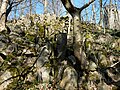 Basaltic blocks on the summit of the Hohe Acht
 -
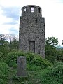 Summit rock on the Hohe Acht with the Kaiser Wilhelm Tower behind
 -
 Kaiser Wilhelm Tower
 -
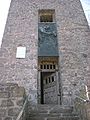
 On the Kaiser Wilhelm Tower


References
[edit]- ^abMap servicesof theFederal Agency for Nature Conservation
- ^abMap service of the Landscape Information System of the Rhineland-Palatinate Nature Conservation Office (Naturschutzverwaltung Rheinland-Pfalz)
- ^ Prominence from Eberhard Jurgalski,Summits in Germany with at least 379 meters of re-ascent – auf sol.co.ukat theWayback Machine(archived 2006-01-18).
Sources
[edit]- d'Hein:Nationaler Geopark Vulkanland Eifel. Ein Natur- und Kulturführer.Gaasterland Verlag, Düsseldorf 2006,ISBN3-935873-15-8
External links
[edit]- WDR Winter Sport Tip – Hohe Acht(in German)
- Rhineland-Palatinate Leisure Portal – Hohe Acht(in German)

| International | |
|---|---|
| National | |