
Hugglescote
| Hugglescote | |
|---|---|
 St. John the Baptist parish church | |
 Hugglescote Location withinLeicestershire | |
| Population | 4,189 (ward,2001 census)[1] |
| OS grid reference | SK4212 |
| Civil parish | |
| District | |
| Shire county | |
| Region | |
| Country | England |
| Sovereign state | United Kingdom |
| Post town | Coalville |
| Postcode district | LE67 |
| Dialling code | 01530 |
| Police | Leicestershire |
| Fire | Leicestershire |
| Ambulance | East Midlands |
| UK Parliament | |
| Website | Hugglescote and Donington le Heath Parish Council |
Hugglescoteis a village on theRiver SenceinNorth West Leicestershire,England. The village is about 1 mile (1.6 km) south of the centre ofCoalville,and its built-up area is now contiguous with the town.
Hugglescote andDonington le Heathwere part of the parish ofIbstockuntil 1878, when they were formed into a separatecivil parish.Against local belief, Hugglescote is not classed as Coalville. The civil parish of Hugglescote and Donington le Heath was reinstated by an order made in May 2010, and the new parish council held its first meeting in May 2011.[2]
Manor
[edit]The manor was held by Hugh le Despencer in 1217 and was in various hands until 1464 when the king granted it to William Hastings.[3]
In 1463William Beaumont, 2nd Viscount Beaumontheld themanorsof Donington and Hugglescote.[4]However, in theWars of the RosesBeaumont had fought for theHouse of Lancasterso he wasattainderedandEdward IVgranted Donington and Hugglescote to theYorkistcourtierWilliam Hastings, 1st Baron Hastings.[4]
As of 1831 the Marquis of hastings was lord of the manor.[5]
The Hastings family'smanor househas been lost. It had aformal gardenin which a red brick building was erected in about 1700 and altered in about 1820.[6]The building survives but part of its stone slate roof has collapsed.[6]
Church and chapels
[edit]Church of England
[edit]There was an old Church of Englandchapel of easein Dennis Street which was replaced by aGeorgianchapel of Saint James[4]in 1776.[7]Hugglescote's population outgrew the chapel and so the presentChurch of England parish churchof SaintJohn the Baptistwas built on a new site in Grange Road and consecrated in 1879. St. John's is aGothic Revivalbuilding designed by the architectJ. B. Everardin anEarly Englishstyle.[8]The first vicar, Canon H. E. Broughton, was installed in 1878 and died in office in 1924. He is commemorated by areredosinstalled in St. John's in 1937 and a nearby road-name, Broughton Street.
St. John's is built largely of local materials:Charnwoodgraniterubble,[9]Swithlandslate,[9]Ibstock brick and Coalville ceramic floor tiles. Thenavehas five-bayarcades[9]withShapgranitecolumns[citation needed]and aclerestorywith pairedlancet windows.[9]St. John's has atranseptalsouth chapel and a central belltower over the crossing.[9]The building was extended in 1887.[9]The tower has aringof eight bells, all cast byJohn Taylor & CoofLoughboroughin 1900.[10]St. John's is aGrade II* listed building.[9]

St. John's has anElizabethanchalicedating from 1575[8]and a parish chest from the former chapel. Theparish registersdate from 1564.[11]
St. John's is the largest place of worship in the area, seating some 600 people. It is now part of a combinedbeneficewith the parishes ofEllistownandSnibston.[12]
Methodist
[edit]AWesleyanchapel in Station Road was completed in 1831 and extended in 1891. It is now HugglescoteMethodistChurch.[13]
Baptist
[edit]Hugglescote had aBaptistchapel in Dennis Street.[14]The building is now closed but the Baptist congregation continues to worship in Hugglescote Community Primary School.[14]
Economic and social history
[edit]

A few historic cottages survive in Dennis Street. 26 and 28 Dennis Street are two timber-framed cottages, one of which has the date 1583 on acollar beam[15]and thus dates from the period thatW. G. Hoskinsidentified as theGreat Rebuildingof England. The gable end has collar and tie beams andqueen struts.[15]The building was extended eastwards in 1761.[15]In 1960 Hoskins considered the original part of the building to be the oldest dated cottage in a Leicestershire village.[16]
16 Dennis Street is a timber-framed cottage withbrick noggingthat was mainly built in the 17th century, although the original part of the cottage was built in 1590, and has some alterations from the 19th or late 18th centuries.[17]The staircase is in a semicircular extension at the rear of the cottage.[17]15 Dennis Street is a cottage built of brick with a Swithland slate roof and the date 1757 on a brick over the front door.[18]
The soil is in some parts of clay but in others a light sandy loam. In 1831 the number of houses was 127 and the population 683.[19]Farmland in the township wasenclosedin 1774.[20]In 1945 this estate was sold by Brigadier C. L. O. Tayleur.[21]
By 1848 Donington and Hugglescote had aNational School.[4]It moved into a new building completed in 1862, and an infants' school was added in 1883. The 1862 and 1883 buildings are now Hugglescote Community Centre.[22]
Construction of theAshby and Nuneaton Joint Railwaybegan in 1869 and it opened in 1873.[23]The ANJR had a branch fromShackerstonethrough Hugglescote toCoalville Town.Hugglescote railway stationhad a junction to the north of it added in 1883, when theCharnwood Forest Railwayopened from here toLoughborough Derby Road.[24]TheLondon, Midland and Scottish Railwayabsorbed both lines in the1923 groupingand withdrew passenger services from both lines in 1931.[23][24]Nationalisation in 1948made the lines part ofBritish Railways,which withdrew freight services from the Charnwood Forest line in 1963[24]and from the Ashby and Nuneaton line in 1971.[23]
Notable residents
[edit]TheVictorianhymnist,Henry Dennis(1818–87) lived in Hugglescote for forty years and is buried in the old Baptist Cemetery off Grange Road:[25]Dennis Street is named after him. In the same cemetery is the tomb ofWilliam Stenson(1770–1861), the mining engineer and founder ofWhitwickColliery, who has sometimes been described as "the father of Coalville".
Amenities
[edit]

Hugglescote now has aCommunity Primary School.[26]The buildings of its former National School (see above) are now a community centre.[22]
The village has onepublic house:, The Gate Inn. It has also aworking men's club.[27]
Roberts Travel Groupare based on Midland Road within the village and provide the local bus service connecting the village withCoalvilleandHinckley.
References
[edit]- ^"Area: Hugglescote (Ward); Key Figures for 2001 Census: Census Area Statistics".Neighbourhood Statistics.Office for National Statistics.Archived fromthe originalon 4 March 2016.Retrieved15 January2012.
- ^"Hugglescote and Donington le Heath Parish Council".Leicestershire Parish Councils.2011. Archived fromthe originalon 13 April 2012.Retrieved17 January2012.
- ^Curtis, John (1831).A Topographical History of the County of Leicester.Ashby-de-la-Zouch: W. Hextall. p. 79
- ^abcdLewis 1931,pp. 69–78.
- ^Curtis (1831), p. 79
- ^abHistoric England."Garden building in the garden of number 79 (1078225)".National Heritage List for England.Retrieved15 January2012.
- ^The Official Guide to North West Leicestershire,undated publication
- ^abPevsner 1960,p. 123.
- ^abcdefgHistoric England."Church of St John the Baptist (1361240)".National Heritage List for England.Retrieved15 January2012.
- ^Dawson, George (20 November 2006)."Hugglescote S John Bapt".Dove's Guide for Church Bell Ringers.Central Council of Church Bell Ringers.Retrieved15 January2012.
- ^Introduction to Coalville,local publication,circa1970
- ^Archbishops' Council."Hugglescote: St John the Baptist, Hugglescote".Church of England.Retrieved15 January2012.
- ^"Hugglescote Methodist Church".Christian Coalville Churches.Retrieved15 January2012.[permanent dead link]
- ^ab"Hugglescote Baptist Church".Christian Coalville Churches.Retrieved15 January2012.[permanent dead link]
- ^abcHistoric England."26 and 28 Dennis Street (1178098)".National Heritage List for England.Retrieved15 January2012.
- ^Pevsner 1960,p. 124.
- ^abHistoric England."16 Dennis Street (1074358)".National Heritage List for England.Retrieved15 January2012.
- ^Historic England."15 Dennis Street (1178089)".National Heritage List for England.Retrieved15 January2012.
- ^Curtis (1831), p. 79
- ^"An ingrossed bill for dividing, allotting and inclosing the Open Fields, Wastes and Commonable Places of Hucklescote, and Donnington on the Heath, in the parish of Ibstock, in the County of Leicester (14 Geo. 3 c. 25)".Journals of the House of Commons.34:567. 1774.Retrieved15 January2012.
- ^Warner; Sheppard; Wade (1945).Particulars of the Hugglescote and Donington estate (with map).Leicester. p. not cited.
{{cite book}}:CS1 maint: location missing publisher (link)[clarification needed] - ^abHugglescote Community Centre
- ^abcSpeller, John."Ashby & Nuneaton Joint Railway (L&NWR/MR)".John Speller's Web Pages.Archived fromthe originalon 6 April 2012.Retrieved15 January2012.
- ^abcSpeller, John."Charnwood Forest Railway".John Speller's Web Pages.Archived fromthe originalon 2 May 2012.Retrieved15 January2012.
- ^Lightwood, James T (1907).Hymn-Tunes and their Story.London: Epworth Press. p. not cited.
- ^"Hugglescote Community Primary School".Archived fromthe originalon 30 December 2011.Retrieved15 January2012.
- ^Hugglescote Social Club
Sources
[edit]- Lewis, Samuel,ed. (1931) [1848].A Topographical Dictionary of England(Seventh ed.). London:Samuel Lewis.pp. 69–78.
- Pevsner, Nikolaus(1960).Leicestershire and Rutland.The Buildings of England.Harmondsworth:Penguin Books.pp. 123–124.
Gallery
[edit]-
 West front of St. John the Baptist parish church
 -
 St. John the Baptist parish church from the southeast
 -
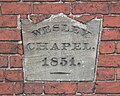 1851 completion stone on Hugglescote Methodist church
 -
 Norwich Union fire insurance mark on Hugglescote Methodist church


External links
[edit]![]() Media related toHugglescoteat Wikimedia Commons
Media related toHugglescoteat Wikimedia Commons
Towns and villages ofNorth West Leicestershire | ||
|---|---|---|
| Towns |  | |
| Large villages | ||
| Small villages |
| |
| Hamlets | ||