
Imbros Gorge
Imbros Gorge(Greek:Φαράγγι Ίμπρου,Faragi Imbrou) is an 11 km longcanyonlocated nearHora Sfakionin southernCrete,theMediterraneanisland. It runs parallel toSamariá Gorge,its narrowest part has 1.60 m and it ends at the village ofKommitádes(8 km/ 650 m for hiking). The Imbros village (aka Nimbros) is located at an altitude of 780 meters and is at the South end of the fertile plain of Askyfou.
The legend tells that two brothers were banished fromImbros,Turkey and lived in the Imbros village, Crete.
The Imbros Gorge mule trail was the only connection betweenChaniaand Hora Sfakion, before the road was built. Remains of this trail can be still seen. The gorge witnessed an evacuation of several thousands ofBritish soldiersduringWorld War IIbefore heading toEgypt.
Hiking:
- The entrance fee is €3.00 in 2024.
- You can pass the gorge all year round except when it's raining or snowing heavily.
- For those who reach Imbros with their own car, they can leave it there, pass the gorge and return to it with a taxi from Kommitádes or walk through the gorge all the way back again, as it is not so tiring.
- As one walks downhill 8 km and 650 m, it is something like half of Samariá Gorge. But Samariá Gorge isscreeabove the river bed, and Imbros Gorge is round scree of the dry creek bed. The Imbros Gorge is strenuous, proper shoes with ankle support should be worn.
References
[edit]- Bötig, Klaus (2010).Kreta - Merian live.Munique: Travel House Media. p. 128.
Gallery
[edit]-
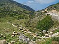 At the entrance
 -
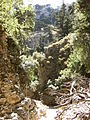
 On the trail
 -
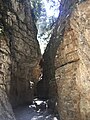
 On the trail
 -
 On the trail
 -
 On the trail
 -
 On the trail
 -
 Mule on the trail


35°14′48″N24°10′5″E/ 35.24667°N 24.16806°E
ThisCretelocation article is astub.You can help Wikipedia byexpanding it. |