
Jiaxiang County
Jiaxiang County
Gia tường huyện Kiasiang; Kiasing | |
|---|---|
 Jiaxiang town center | |
 Location in Jining | |
 Jiaxiang Location of the seat in Shandong | |
| Coordinates:35°24′29″N116°20′31″E/ 35.408°N 116.342°E | |
| Country | People's Republic of China |
| Province | Shandong |
| Prefecture-level city | Jining |
| Area | |
| • Total | 838.56 km2(323.77 sq mi) |
| Elevation | 40 m (130 ft) |
| Population (2019) | |
| • Total | 933,614 |
| • Density | 1,100/km2(2,900/sq mi) |
| Time zone | UTC+8(China Standard) |
| Postal code | 272400 |
| Website | www |
Jiaxiang County(simplified Chinese:Gia tường huyện;traditional Chinese:Gia tường huyện;pinyin:Jiāxiáng Xiàn) is a county in the southwest ofShandongprovince, People's Republic of China. It is under the administration ofJiningCity.
The population was 871,920 in 2011.[1]
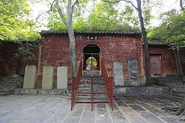
The cultural heritagesite of the Carved Stones in the Tombs of the Wu Familyis in this county. In 1961, it was added to the list of national historical and cultural monuments. The county is also home to the temple ofZengzi,a Confucian disciple and philosopher. TheJining Qufu Airportis located in the southern part of the county.
-
 Temple of Zengzi
 -
 Wu family shrines
 -
 Qingshan Temple


Administrative divisions[edit]
As 2012, this county is divided to 8 towns and 7 townships.[2]
- Towns
|
|
- Townships
|
|
Climate[edit]
| Climate data for Jiaxiang (1991–2020 normals, extremes 1981–2010) | |||||||||||||
|---|---|---|---|---|---|---|---|---|---|---|---|---|---|
| Month | Jan | Feb | Mar | Apr | May | Jun | Jul | Aug | Sep | Oct | Nov | Dec | Year |
| Record high °C (°F) | 16.5 (61.7) |
23.6 (74.5) |
28.1 (82.6) |
33.3 (91.9) |
37.7 (99.9) |
40.3 (104.5) |
41.0 (105.8) |
36.9 (98.4) |
36.0 (96.8) |
35.4 (95.7) |
26.5 (79.7) |
21.0 (69.8) |
41.0 (105.8) |
| Mean daily maximum °C (°F) | 4.9 (40.8) |
8.9 (48.0) |
14.9 (58.8) |
21.3 (70.3) |
26.8 (80.2) |
31.6 (88.9) |
32.0 (89.6) |
30.7 (87.3) |
27.2 (81.0) |
21.6 (70.9) |
13.4 (56.1) |
6.7 (44.1) |
20.0 (68.0) |
| Daily mean °C (°F) | −0.4 (31.3) |
3.2 (37.8) |
9.2 (48.6) |
15.5 (59.9) |
21.1 (70.0) |
26.1 (79.0) |
27.6 (81.7) |
26.1 (79.0) |
21.5 (70.7) |
15.6 (60.1) |
7.9 (46.2) |
1.5 (34.7) |
14.6 (58.3) |
| Mean daily minimum °C (°F) | −4.6 (23.7) |
−1.4 (29.5) |
3.9 (39.0) |
9.9 (49.8) |
15.4 (59.7) |
20.9 (69.6) |
23.7 (74.7) |
22.3 (72.1) |
16.9 (62.4) |
10.6 (51.1) |
3.3 (37.9) |
−2.7 (27.1) |
9.9 (49.7) |
| Record low °C (°F) | −16.2 (2.8) |
−14.7 (5.5) |
−8.8 (16.2) |
−3.1 (26.4) |
4.3 (39.7) |
10.5 (50.9) |
16.7 (62.1) |
10.8 (51.4) |
4.9 (40.8) |
−1.1 (30.0) |
−10.7 (12.7) |
−13.8 (7.2) |
−16.2 (2.8) |
| Averageprecipitationmm (inches) | 7.5 (0.30) |
14.1 (0.56) |
17.9 (0.70) |
35.7 (1.41) |
54.2 (2.13) |
79.9 (3.15) |
173.5 (6.83) |
176.1 (6.93) |
70.1 (2.76) |
31.6 (1.24) |
28.5 (1.12) |
9.6 (0.38) |
698.7 (27.51) |
| Average precipitation days(≥ 0.1 mm) | 2.9 | 3.9 | 4.1 | 5.2 | 6.3 | 7.4 | 10.8 | 10.7 | 7.1 | 5.3 | 4.9 | 3.4 | 72 |
| Average snowy days | 2.8 | 2.6 | 0.7 | 0.1 | 0 | 0 | 0 | 0 | 0 | 0 | 0.8 | 1.7 | 8.7 |
| Averagerelative humidity(%) | 65 | 60 | 58 | 62 | 65 | 63 | 77 | 82 | 76 | 70 | 70 | 68 | 68 |
| Mean monthlysunshine hours | 137.5 | 142.0 | 187.2 | 212.2 | 229.2 | 208.4 | 182.1 | 175.3 | 165.7 | 170.3 | 145.2 | 139.8 | 2,094.9 |
| Percentpossible sunshine | 44 | 46 | 50 | 54 | 53 | 48 | 42 | 43 | 45 | 49 | 48 | 46 | 47 |
| Source:China Meteorological Administration[3][4] | |||||||||||||
References[edit]
Wikimedia Commons has media related toJiaxiang County.
- ^Jining Statistical Almanac, 2011,inJining Statistical Information NetArchived2015-04-05 at theWayback Machine
- ^Tế ninh thị - hành chính khu hoa võng www.xzqh.org(in Chinese). XZQH.Retrieved2012-05-24.
- ^Trung quốc khí tượng sổ cư võng – WeatherBk Data(in Simplified Chinese).China Meteorological Administration.Retrieved12 August2023.
- ^ Trung quốc khí tượng sổ cư võng(in Simplified Chinese).China Meteorological Administration.Retrieved12 August2023.