
Kabini River
This article includes a list of generalreferences,butit lacks sufficient correspondinginline citations.(December 2019) |
| Kapila | |
|---|---|
 Kapila River from Kabinigiri, Kerala | |
| Location | |
| Country | India |
| State | Kerala,Karnataka |
| Physical characteristics | |
| Source | Panamaram |
| • location | Wayanad district,Kerala,India |
| • coordinates | 11°48′01″N76°04′29″E/ 11.80028°N 76.07472°E |
| Mouth | Tirumakudal Narsipur |
• location | Mysore district,Karnataka,India |
• coordinates | 12°12′56″N76°54′40″E/ 12.21556°N 76.91111°E |
TheKabini River(Kapila River)is one of the major tributaries of the riverCauveryin southernIndia,It originates nearKavilumparainKozhikode districtofKeralastate by the confluence of thePanamaram Riverand theMananthavady River.It flows eastward throughWayanad district,enteringMysore districtofKarnataka,to join theKaveri RiverinMysore districtofKarnataka.[1]
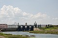
Close to the town ofSargurit forms the hugeKabini Reservoir.Thebackwatersof the Kabini reservoir are very rich in wildlife especially in summer when the water level recedes to form rich grassy meadows. The Kabini dam is 2,284 ft (696 m) in length with an original gross storage of 19.52 tmcft. The Kabini Dam is situated between villages Bichanahalli and Bidarahalli having distance of 17 km (11 mi) 6 km away fromSargurtown in Heggadadevana kote taluk,Mysoredistrict, Karnataka.[2]
Wildlife[edit]
The Kabini Forest Reserve is one of the most popularwildlifedestinations of Karnataka, probably because of its accessibility, lush green landscape surrounding a large lake, and sightings of herds of elephants, tigers. It is 61 km (38 mi) away from Mysuru and 205 km (127 mi) fromBengaluru,and comprises the south-eastern part ofNagarahole National Park.Situated on the banks of the kabini River, the reserve is spread over 55 acres (22 ha) of forestland, steep valleys, and water bodies. Once a private hunting lodge of theMaharajaof Mysore, kabini was a popularshikarhotspot forBritish Viceroysand Indian royalty.[3]Now it is considered to be one of the best Wildlife National Parks in India, famous for its spectacular wildlife and bird life. There are around 120 tigers, 100+ leopards, four types of deer, Sloth bear, Indian Gaurs and elephants in the Nagarahole National Park.[4]
Course[edit]

The river originates in the Pakramthalam hills atKuttiady-Mananthavadyroad. Makkiyad river and Periya river join it near Korome and Valad respectively. After flowing throughMananthavadytown,Panamaramriver joins Kabini near Payyampally. One branch of the Panamaram river starts from theBanasura Sagarreservoir near Padinjarethara and the other branch of the river start fromLakkidihills. After traversing 2 kilometres (1.2 mi) from the confluence of Panamaram river kabini forms an island calledKuruva Island,spreading over 520 acres (2.1 km2) with diverse flora and fauna. Within 20 km (12 mi) it reaches the kabini reservoir borderingKeralaandKarnatakafor some distance. Between kabini reservoir and Kuruva island Kalindi river joins kabini. Kalindi river originates fromBrahmagirihills which on reaching nearThirunelli Templethe rivuletPapanasinijoins it. Taraka and Nugu are the two small rivers in Heggadadevana kote taluk that join the Kapila (Kabini river).[5]
Kabini dam[edit]
| Kabini dam | |
|---|---|
 | |
| Coordinates | 11°58′25″N76°21′10″E/ 11.9735°N 76.3528°E |
| Dam and spillways | |
| Type of dam | Earthen Dam with Left Bankspillway |
| Impounds | Kapila River |
| Height | 166 ft. aboveRiver Bed Level |
| Length | 12,927 ft. |
TheKabini damis built on the River Kapila in the district ofMysore.The dam is 696 meters in length and was built in 1974. The exact location of the dam is near village Beechanahally, in TalukHeggadadevanakote.The catchment area of the dam is 2,141.90 km2.It caters to the needs of around 22 villages and 14 hamlets and also a prominent source of drinking water to Mysuru andBengaluru.Further significant amount of water is discharged to theMettur reservoirinTamilnaduto fulfill the state's needs.[6]
The dam is spread over an area of 55 hectares covering forests, rivers, lakes andvalleys.This dam also provides water to the combined system of Sagaredoddakere and Upper Nugu Dams. There is an arrangement of lifting and transfer of 28.00 TMC of water during themonsoonsmonths from the kabini dam to the other two smaller dams.[7]
Kabini Bridge[edit]
TheKabini Bridgeon this river is aHeritage monument.[8]
Image gallery[edit]
-
 Indian coraclesare used on the Kabini river
 -
 Kabini reservoir
 -
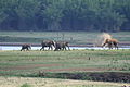 Elephant family on the Kabini river bank
 -
 The river Kabini inNanjangud


References[edit]
- ^"Kabini or Kapila River".District Administration Mysuru, GOI.Retrieved2 March2024.
- ^"Kabini or Kapila River".District Administration Mysuru, GOI.Retrieved2 March2024.
- ^"KABINI WILDLIFE RESERVE AND KABINI RIVER".Kabini Wildlife.Retrieved2 March2024.
- ^"Nagarahole Tiger Reserve".Karnataka Forest Department.Retrieved2 March2024.
- ^Singh, AK (2 August 2022).Kabini And The Jungle Stories: A Royal Legacy, Myths, Legends & The Truth.Notion Press.ISBN9798887498225.Retrieved2 March2024.
- ^"Water released from Kabini reservoir reaches Mettur dam".The Hindu. 17 June 2018.Retrieved2 March2024.
- ^Kandya, Ranjith (17 December 2018)."80,000 cusecs out from Kabini reservoir, highest ever".Deccan Herald.Retrieved2 March2024.
- ^"285-year-old Kabini rail-cum-road bridge near Nanjangud to get facelift".Deccan Herald. 5 October 2020.Retrieved2 March2024.