
Karaman Province
This articleneeds additional citations forverification.(May 2011) |
Karaman Province
Karaman ili | |
|---|---|
 Yaylapazarı, Ermenek | |
 Location of the province within Turkey | |
| Country | Turkey |
| Seat | Karaman |
| Government | |
| •Governor | Hüseyin Engin Sarıibrahim |
| Area | 8,678 km2(3,351 sq mi) |
| Population (2022)[1] | 260,838 |
| • Density | 30/km2(78/sq mi) |
| Time zone | UTC+3(TRT) |
| Area code | 0338 |
| Website | www |
Karaman Province(Turkish:Karaman ili) is aprovinceof south-centralTurkey.Its area is 8,678 km2,[2]and its population is 260,838 (2022).[1]According to the2000 census,the population was 243,210. The population density is 30 people/km2.Thetraffic codeis 70. The capital is the city ofKaraman.Karaman was the location of theKaramanidBeylik,which came to an end in 1486.
Districts and Towns
[edit]
Karaman Province is divided into 6districts:
Towns includeSudurağı,Akçaşehir,andGüneyyurt.
Place of interest
[edit]- Binbirkilise,a region aroundMount Karadağ30 km (19 mi) north of Karaman withByzantinechurch ruins.
Churches
[edit]- Çeşmeli Kilise (Surp Asvadzadzin Ermeni Kilisesi)
- Fisandon Church
- Binbir Church
See also
[edit]- Görmeli,a village on the hillside of theTaurus Mountainsnear Ermenek
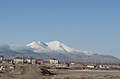
- Mount Karadağ,an extinct volcano north of Karaman city
- List of populated places in Karaman Province
Gallery
[edit]-
-
 Street in Karaman
 -
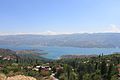
 Taşeli-Plateau, Ermenek River
 -
 Yeşildere, Akköprü
 -
 Yeşildererock formation
 -
 Ermenekold houses
 -
 Ruins ofBinbirkilise,meaning "Thousand and One Churches" in Üçkuyu
 -
 Yaylapazarı,Ermenek
 -
-
 Houses in Taşkale
 -
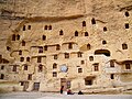 Storage caves of Taşkale are probably of ancient origin, but some may have been dug into the rock face in the post-Byzantine period.


References
[edit]- ^ab"Address-based population registration system (ADNKS) results dated 31 December 2022, Favorite Reports"(XLS).TÜİK.Retrieved19 September2023.
- ^"İl ve İlçe Yüz ölçümleri".General Directorate of Mapping.Retrieved19 September2023.
External links
[edit]Wikimedia Commons has media related toKaraman Province.
- (in Turkish)Karaman governor's official website
- (in Turkish)Karaman municipality's official website
- (in English)Karaman weather forecast information
37°01′23″N33°05′39″E/ 37.02306°N 33.09417°E
See also
[edit]

| International | |
|---|---|
| National | |
| Geographic | |
This geographical article about a location inKaraman Province,Turkeyis astub.You can help Wikipedia byexpanding it. |