
Kausani
Kausani | |
|---|---|
     Clockwise from top: Sunrise at Kausani, View ofTrisulandPanchchulipeaks,Almora-KarnaprayagRoad, Anasakti Ashram and Tea Plantations. | |
 Kausani Location in Uttarakhand, India  Kausani Kausani (India) | |
| Coordinates:29°50′N79°36′E/ 29.84°N 79.60°E | |
| Country | |
| State | Uttarakhand |
| District | Bageshwar |
| Area | |
| • Total | 5.2 km2(2.0 sq mi) |
| Elevation | 1,890 m (6,200 ft) |
| Population (2011) | |
| • Total | 2,408 |
| • Density | 460/km2(1,200/sq mi) |
| Languages | |
| • Official | Hindi Dhabela |
| • Spoken | Kumaoni |
| Time zone | UTC+5:30(IST) |
| PIN | |
| Telephone code | 05962 |
| Vehicle registration | UK-02 |
| Website | uk |
Kausani(Kumaoni:Kôsānī) is ahill stationandVillagesituated inBageshwar districtin the state ofUttarakhand,India.It is known for its scenery and its 300 km-wide panoramic view ofHimalayanpeaks likeTrisul,Nanda DeviandPanchchuli.Mahatma Gandhicalled this place the 'Switzerland of India',[4][5]due to similarity in landscapes.
History
[edit]DuringIndependence of Indiain 1947, Kausani was situated in theAlmora District[6]till 15 September 1997 after whichBageshwar districtwas carved out of Almora district.[7]On 9 November 2000, the State ofUttarakhandwas created from the Himalayan and adjoining northwestern districts ofUttar Pradesh.[8]
Geography
[edit]
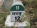
Kausani is located at29°51′15″N79°35′48″E/ 29.8541°N 79.5966°E[9]inBageshwar districtofUttarakhand,Indiaat a distance of 40 km (25 mi) fromBageshwarcity,[10]the administrative Headquarter of Bageshwar District. Kausani is located 52 km (32 mi) north ofAlmora,a major hill station and the historical capital ofKumaon Kingdom.[11]Kausani lies in theKumaon divisionand is situated 123 km (76 mi) North-East ofNainital,the Headquarters of Kumaon. Nearby Towns includeGarur(14 km (8.7 mi)) andSomeshwar(12 km (7.5 mi)). It has an average elevation of 1,890 m (6,200 ft) above mean Sea Level. Kausani lies atop a ridge amidst dense pine trees overlookingSomeshwarvalley on one side andGarurand Katyuri valley[4]on the other onAlmora-Bageshwar-DidihatHighway. Kausani is a part of the Lesser Himalayas, a region watered by rivers like Kosi, Gomti and Ramganga.[12]Their banks, known as seras, are highly fertile.
Climate
[edit]Temperature ranges between 10 °C to 26 °C in summers.[13]Winters are quite cold with temperature ranging between 15 °C to 2 °C.[13]Rainfall lies between Max 3048 mm and Min 1777 mm.[13]
Demographics
[edit]According to Census 2011 information the location code or village code of Kausani State village is 051443.[14]Kausani State village is located inGarurTehsil ofBageshwar districtinUttarakhand,India.It is situated 18 km (11 mi) away from sub-district headquarterGarurand 40 km (25 mi) away from district headquarterBageshwar.As per 2009 stats, Kausani is the gram panchayat of Kausani State village.[14]
Kausani State is a large village located in Garur of Bageshwar district, Uttarakhand with total 512 families residing.[15]The total geographical area of village is 429.92 hectares.[16]Kausani State has a total population of 2,408 of which 1195 are males while 1213 are females as per Population Census 2011.[16]
In Kausani State village population of children with age 0-6 is 334 which makes up 13.87% of total population of village.[15][16]Averagesex ratioof Kausani State village is 1015 which is higher than Uttarakhand state average of 963. Child Sex Ratio for the Kausani State as per census is 825,[16]lower than Uttarakhand average of 890.
Kausani State village has higher literacy rate compared to Uttarakhand. In 2011,literacy rateof Kausani State village was 87.80%[15][16]compared to 78.82% of Uttarakhand. In Kausani State Male literacy stands at 96.25% while female literacy rate was 79.76%.[16]
In Kausani State village, most of the villagers are fromSchedule Caste(SC). Schedule Caste (SC) constitutes 45.47%[15]while Schedule Tribe (ST) were 0.33% of total population in Kausani State village.[16]
In Kausani State village out of total population, 1086 were engaged in work activities.[15][16]54.24% of workers describe their work as Main Work (Employment or Earning more than 6 Months) while 45.76% were involved in Marginal activity providing livelihood for less than 6 months.[15]Of 1086 workers engaged in Main Work, 187 were cultivators (owner or co-owner) while 16 were Agricultural labourer.[16]
As perconstitution of IndiaandPanchyati Raaj Act,Kausani State village is administrated bySarpanch(Head of Village) who is elected representative of village.[14]Kumaoniis spoken by majority however,HindiandSanskrit[17]are the official languages.
Economy
[edit]Many of Kausani's men serve in thearmy– a phenomenon common in the northern hill towns of the country. The rest of the population depends onagricultureand allied activities,tourismand other small businesses for their livelihood.[18]The local handloom factory produces shawls, woolen apparel and blankets. Besides handloom products, the factory sells other local artefacts and tea from Kausani's tea estate.[18]Kausani Tea Estate was established in 2000-2001 and produces 70,000 kg Tea.[19]
In Kausani State village out of total population, 1086 were engaged in work activities.[15][16]54.24% of workers describe their work as Main Work (Employment or Earning more than 6 Months) while 45.76% were involved in Marginal activity providing livelihood for less than 6 months.[15]Of 1086 workers engaged in Main Work, 187 were cultivators (owner or co-owner) while 16 were Agricultural labourer.[16]
Tourism
[edit]
Tourist attractions
[edit]Anashakti Ashram is a quiet and revered place whereMahatma Gandhispent some days[20]and wrote his commentary ofAnashakti Yog.[21]The KMVN (Kumaon Mandal Vikas Nigam) resthouse in Kausani is an ideal place to stay and it provides panoramic views of the mountains.
-
 Towards Kausani
 -
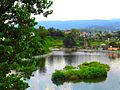 Baijnath Lake
 -
 Anashakti Ashram
 -
 A view of the mountain range
 -
 Anashakti Ashram (Aarti room)
 -
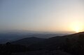 Sunrise at Kausani


Lakshmi Ashramis one kilometre away from the Kausani, and is a center run byKumauniwomen and dedicated to social service and the upliftment of women. Gandhiji's disciple,Sarla Behn(Kaitherine Heileman) established the ashram in 1946,[22][23]and spent her life here doing social service and also established Anashakti Ashram. Lakshmi ashram is located in a solitary area among dense pine forest.
Tea gardens (5 km on Bageshwar Road),[24]Baijnath group of temples(16.5 km on Bageshwar Road)[25]andBageshwarare the places of interest nearby. A fabulous collection of high quality woollen shawls, exquisitely designed by the local weavers, can be purchased from Kumaon Shawl Emporium.[26]
Pant Museum is named after the famous Hindi poet,Sumitranandan Pant,who was born in Kausani,[27]the Museum has the articles of his daily use, drafts of his poems, letters, his awards etc. This Museum is at a short distance from the Kausani bus terminal.
To boost theastrotourism in India,the government is setting up anobservatoryhere under theVibrant Villages programme.[28]
Treks Near Kausani
[edit]
- Pindari GlacierTrek
- Kafni GlacierTrek
- Sunder Dhunga Trek
- Milam GlacierTrek
- Rudrahari cave temple trek
- Kafari (3 km from Kausani)
Places around Kausani
[edit]
- Almora
- Baijnath
- Bageshwar
- Garur
- Chaukori
- Berinag
- Gwaldam
- Badhan Gari Mandir
- Angayaari Mandir
- Kote Mai Mandir
- Krishna gari
- Laubanj Village
- Rudradhari Dham
- Saroli
Peaks Visible from Kausani
[edit]Transport
[edit]Pantnagar Airport,located inPantnagar(178 km) is the primary Airport serving entire Kumaon Region.Indira Gandhi International Airport,located inDelhi(431 km) is the nearest international Airport.Kathgodam railway station(145 km) is the nearest railway station. Kausani is well connected by motorable roads with major destinations of Uttarakhand state and northern India. Bus Services are provided by Uttarakhand Transport Corporation and K.M.O.U.(Kumaon Motor Owners Union limited). Regular Taxis are available toAlmora,Bageshwar,Garur,someshwarand other major destinations of Kumaon region.
Education
[edit]There are mainly government-run, private unaided (no government help) and private aided schools in the city. The language of instruction in the schools is eitherEnglishorHindi.The main school affiliations areCBSEand UBSE, the state syllabus defined by the Uttarakhand Board of School Education of theGovernment of Uttarakhand.Kausani State village has higher literacy rate compared to Uttarakhand. In 2011, literacy rate of Kausani State village was 87.80%[15][16]compared to 78.82% of Uttarakhand. In Kausani State Male literacy stands at 96.25% while female literacy rate was 79.76%.[16]
In Films
[edit]The movie1942: A Love Storywas filmed in this region and bears a resemblance to depict pre-independence India for filming purpose.
Notable people
[edit]- Sumitranandan Pant(20 May 1900 – 28 December 1977) was born in Kausani Village.
- Mahatma Gandhi(2 October 1869 – 30 January 1948) stayed here for 14 days at the Anashakti Ashram, while scripting his book titled ‘Anashakti Yoga’.
- Harish Bisht- Eastern Naval Command chief was born in Kausani Village.
References
[edit]- ^"Pin Code of Kausani in Uttarakhand".www.mapsofindia.com.Retrieved28 August2016.
- ^"Kausani Pin code".www.areapincodes.in.Archived fromthe originalon 10 May 2017.Retrieved28 August2016.
- ^"Pin Code of Kausani".pincodearea.in.Retrieved1 November2016.
- ^ab"PHOTO उत्तराखंडः इन 5 जगहों पर मना सकते हैं गर्मियों की छुट्टियां".livehindustan.com.Retrieved28 August2016.
- ^"Uttarakhand: In the lap of Himalayas | Latest News & Updates at Daily News & Analysis".22 September 2011.Retrieved28 August2016.
- ^Times World Atlas,1967 Edition, Plate 30.
- ^"development gains elude kumaon's holy place".Retrieved3 August2016.
- ^"About Us".Government of Uttarakhand.Retrieved17 July2012.
- ^"Maps, Weather, and Airports for Kausani, India".www.fallingrain.com.Retrieved28 August2016.
- ^Indusnettechnologies, Goutam Pal, Dipak K S, SWD."Location: District of Bageshwar, Uttarakhand, India".bageshwar.nic.in.Retrieved28 August2016.
{{cite web}}:CS1 maint: multiple names: authors list (link) - ^Omacanda Hāṇḍā (2002).History of Uttaranchal.Indus Publishing. pp. 71–.ISBN978-81-7387-134-4.Retrieved22 July2012.
- ^"Travel: Kausani, a little bubble of peace and beauty".10 December 2015. Archived from the original on 10 December 2015.Retrieved28 August2016.
{{cite news}}:CS1 maint: unfit URL (link) - ^abcIndusnettechnologies, Goutam Pal, Dipak K S, SWD."Excursion: District of Bageshwar, Uttarakhand, India".bageshwar.nic.in.Retrieved28 August2016.
{{cite web}}:CS1 maint: multiple names: authors list (link) - ^abc"kausani state - Village Overview".Retrieved28 August2016.
- ^abcdefghi2011 census, BAGESHWAR(PDF).Retrieved4 August2016.
- ^abcdefghijklm"Kausani State Village Population - Garud - Bageshwar, Uttarakhand".www.census2011.co.in.Retrieved28 August2016.
- ^Trivedi, Anupam (19 January 2010)."Sanskrit is second official language in Uttarakhand".Hindustan Times.Archived fromthe originalon 1 February 2012.Retrieved29 July2012.
- ^ab"Kausani: Of serene locales, tranquil trails and glorious sunsets".11 March 2016.Retrieved28 August2016.
- ^Dehradun, NIC, Uttarakhand State Unit."Kausani Tea Factory: Uttarakhand Tea Development Board, Government Of Uttarakhand, India".utdb.uk.gov.in.Retrieved28 August2016.
{{cite web}}:CS1 maint: multiple names: authors list (link) - ^"The Rock Street Journals of Kumaon".Archived fromthe originalon 24 February 2016.Retrieved28 August2016.
- ^"Kausani Hill Station, Uttarakhand".www.euttaranchal.com.Retrieved28 August2016.
- ^George Alfred James (2013).Ecology Is Permanent Economy: The Activism and Environmental Philosophy of Sunderlal Bahuguna.SUNY Press. pp. 228–.ISBN978-1-4384-4673-8.
- ^"Kausani's 70-year-old Laxmi Ashram faces challenges - Times of India".Retrieved28 August2016.
- ^"Kausani Tea Gardens".www.euttaranchal.com.Retrieved28 August2016.
- ^"Baijnath Group of Temple Kausani and Bageshwar Road by Road, Distance Between Baijnath Group of Temple Kausani and Bageshwar Road, Distance by Road from Baijnath Group of Temple Kausani and Bageshwar Road with Travel Time, Bageshwar Road Distance from Baijnath Group of Temple Kausani, Driving Direction Calculator from Baijnath Group of Temple Kausani and Bageshwar Road".
- ^"Kausani, Uttarakhand Tourism Development Board".uttarakhandtourism.gov.in.Retrieved28 August2016.
- ^"Kausani: The Switzerland Of India: A Great Tourist Place".www.merapahad.com.Retrieved28 August2016.
- ^India’s new tourism boom is in the sky. Uttarakhand to Andamans, stargazing on the rise,The Print, 5 June 2023.