Kidal Cercle
Kidal | |
|---|---|
 | |
 Kidal Cercle in Mali | |
| Country | |
| Region | Kidal Region |
| Capital | Kidal |
| Area | |
| • Total | 21,353 km2(8,244 sq mi) |
| Population (2009)[2] | |
| • Total | 33,087 |
| • Density | 1.5/km2(4.0/sq mi) |
| Time zone | UTC+0(GMT) |
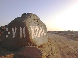
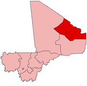
Kidal Cercleis an administrative subdivision of theKidal RegionofMali.The administrative center(chef-lieu)is the town ofKidal.Thecercleis divided into rural and urbancommunes,and below this, quarters/villages. In 2009 the cercle had a population of 33,087.[2]
The climate is typical Saharian with very little rainfall and large fluctuations in temperature. The average annual rainfall is around 130 mm but there are large year-to-year variations with 204 mm recorded in 1999 and only 66 mm in 1990.[1]
The mountain region ofAdrar des Ifoghaswastakenby French and Chadian forces on 22 February 2013 as part of theNorthern Mali conflict.The area of In Arab, nearAnefif,wascapturedbyMNLAforces on 29–30 March 2013.
Communes
[edit]The Kidal Cercle contains the followingcommunes:[3]
References
[edit]- ^abProgramme de renforcement des capacités nationales pour une gestion stratégique du développement (PRECAGED): Schéma d'aménagement et de développement du Cercle de Kidal,République du Mali: Ministère de l'économie programme des nations unies et des finances, 2002, archived fromthe originalon 2012-03-17,retrieved2011-08-20
- ^abResultats Provisoires RGPH 2009 (Région de Kidal)(PDF),République de Mali: Institut National de la Statistique, archived fromthe original(PDF)on 2012-07-27,retrieved2012-05-12
- ^Communes de la Région de Kidal(PDF)(in French), Ministère de l’administration territoriale et des collectivités locales, République du Mali, archived fromthe original(PDF)on 2012-03-09.
18°30′N1°25′E/ 18.500°N 1.417°E


