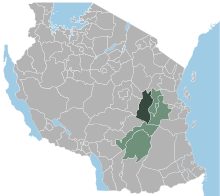
Kilosa District
Kilosa | |
|---|---|
| Wilaya ya Kilosa, Mkoa wa Morogoro | |
 Kilosa District of Morogoro Region | |
| Country | |
| Region | Morogoro Region |
| Area | |
| • Total | 11,773 km2(4,546 sq mi) |
| Population (2022) | |
| • Total | 617,032 |
| • Density | 52/km2(140/sq mi) |

Kilosa District[1]is one of the sixdistrictsof theMorogoro RegionofTanzania.Its administrative seat is the town ofKilosa.Kilosa District covers 14,918 square kilometres (5,760 sq mi).[2]It is bordered to the north by theManyara Region,to the northeast by theTanga Region,to the east byMvomero District,to the southeast byMorogoro Rural District,to the south byKilombero District,to the southwest by theIringa Regionand to the west by theDodoma Region.Kilosa District is home toMikumi National Park.
According to the 2022 Tanzania National Census, the population of the Kilosa District was 617,032.[3][4]
Administrative subdivisions
[edit]Constituencies
[edit]For parliamentary elections, Tanzania is divided into constituencies. As of the 2015 elections Kilosa District had two constituencies:[5]
Divisions
[edit]As of 1997[update],Kilosa District was administratively divided into nine divisions.[2]
1997 divisions
[edit]The nine 1997 divisions were:
- Gairo Division, the northernmost part of Kilosa District,
- Kilosa Division,
- Kilosa Mijni (municipality)
- Kimamba Division,
- Magole Division,
- Masanze Division,
- Mikumi Division,
- Rudewa Division,
- Ulaya Division, the central part of southern Kilosa District.
Wards
[edit]As of 2002[update],Kilosa District was administratively divided into forty- sixwards:[4]
In 2012 the following eight wards became part of the newly createdGairo District:
The thirty-eight wards remaining in Kilosa district from 2012:
Transport
[edit]The town of Kilosa has astationon theCentral LineofTanzanian Railways.It is also a junction for a branch railway to thebreak-of-gaugetransshipment station atKidatu.
Notes
[edit]- ^Kilosa District (Approved)atGEOnet Names Server,United States National Geospatial-Intelligence Agency
- ^ab"Morogoro Region Socio-Economic Profile"(PDF).The Planning Commission, Dar es Salaam, and The Regional Commissioner's Office, Morogoro. 1997.Archived(PDF)from the original on 30 May 2004.
- ^"Tanzania: Administrative Division (Regions and Districts) - Population Statistics, Charts and Map".www.citypopulation.de.Retrieved2024-02-11.
- ^ab"2002 Population and Housing General Report: Morogoro: Kilosa".Archived fromthe originalon 20 March 2004.
- ^"Organisations located in Kilosa District - Tanzania".African Development Information.
