
Kisarazu
Kisarazu
Mộc canh tân thị | |||||||||
|---|---|---|---|---|---|---|---|---|---|

| |||||||||
 Flag  Seal | |||||||||
 Location of Kisarazu in Chiba Prefecture | |||||||||
 Kisarazu | |||||||||
| Coordinates:35°22′33.5″N139°55′0.6″E/ 35.375972°N 139.916833°E | |||||||||
| Country | Japan | ||||||||
| Region | Kantō | ||||||||
| Prefecture | Chiba | ||||||||
| Government | |||||||||
| • Mayor | Yoshikuni Watanabe | ||||||||
| Area | |||||||||
| • Total | 138.95 km2(53.65 sq mi) | ||||||||
| Population (December 2020) | |||||||||
| • Total | 136,023 | ||||||||
| • Density | 980/km2(2,500/sq mi) | ||||||||
| Time zone | UTC+9(Japan Standard Time) | ||||||||
| Phone number | 0438-23-7111 | ||||||||
| Address | 1-1 Shiomi, Kisarazu-shi, Chiba-ken 292-8501 | ||||||||
| Climate | Cfa | ||||||||
| Website | Official website | ||||||||
| Symbols | |||||||||
| Flower | Satsuki azalea | ||||||||
| Tree | Camellia | ||||||||


Kisarazu(Mộc canh tân thị,Kisarazu-shi)is acitylocated inChiba Prefecture,Japan.As of 1 December 2020[update],the city had an estimatedpopulationof 136,023 in 63,431 households and apopulation densityof 980 persons per km2.[1]The total area of the city is 138.95 square kilometres (53.65 sq mi).
Geography
[edit]Kisarazu is located in the midwestern part of theBōsō Peninsula,approximately 30 kilometers southwest of the prefectural capital atChibaand 70 to 80 kilometers from central Tokyo. TheTokyo Bay Aqua-Line,abridge-tunnelacrossTokyo Bay,connects Kisarazu and the cities ofKawasakiandYokohamainKanagawa Prefecture,shortening the road distance to central Tokyo to 30 to 40 kilometers.
The city area extends from east to west, and the western part of the city is the flat land of theKanto Plain,and the eastern part is the plateau of the Kisarazu Plateau and theBoso Hill Range. The Tokyo Bay coastal area is an industrial landfill from the south coast of Kisarazu Port to the direction ofKimitsu.The city's main river is the Obitsu River, which is the second longest river in the prefecture after theTone Riverand has a total length of 88 kilometers. There are no particularly high mountains in the city, and even the highest point is about 200 meters above sea level.
Neighboring municipalities
[edit]Chiba Prefecture
Climate
[edit]Kisarazu has ahumid subtropical climate(KöppenCfa) characterized by warm summers and cool winters with light to no snowfall. The average annual temperature in Kisarazu is 15.8 °C (60.4 °F). The average annual rainfall is 1,650.7 mm (64.99 in) with October as the wettest month. The temperatures are highest on average in August, at around 26.8 °C (80.2 °F), and lowest in January, at around 5.6 °C (42.1 °F).[2]
| Climate data for Kisarazu (2006−2020 normals, extremes 2006−present) | |||||||||||||
|---|---|---|---|---|---|---|---|---|---|---|---|---|---|
| Month | Jan | Feb | Mar | Apr | May | Jun | Jul | Aug | Sep | Oct | Nov | Dec | Year |
| Record high °C (°F) | 19.3 (66.7) |
23.3 (73.9) |
24.4 (75.9) |
26.0 (78.8) |
32.7 (90.9) |
34.7 (94.5) |
36.1 (97.0) |
37.6 (99.7) |
35.3 (95.5) |
31.6 (88.9) |
26.4 (79.5) |
23.0 (73.4) |
37.6 (99.7) |
| Mean daily maximum °C (°F) | 9.6 (49.3) |
10.4 (50.7) |
14.0 (57.2) |
18.6 (65.5) |
23.5 (74.3) |
25.7 (78.3) |
29.6 (85.3) |
31.3 (88.3) |
27.5 (81.5) |
21.9 (71.4) |
16.8 (62.2) |
12.1 (53.8) |
20.1 (68.1) |
| Daily mean °C (°F) | 5.6 (42.1) |
6.2 (43.2) |
9.5 (49.1) |
13.8 (56.8) |
18.6 (65.5) |
21.4 (70.5) |
25.3 (77.5) |
26.8 (80.2) |
23.2 (73.8) |
18.0 (64.4) |
12.8 (55.0) |
8.1 (46.6) |
15.8 (60.4) |
| Mean daily minimum °C (°F) | 1.6 (34.9) |
2.2 (36.0) |
5.3 (41.5) |
9.5 (49.1) |
14.6 (58.3) |
18.1 (64.6) |
22.3 (72.1) |
23.7 (74.7) |
20.1 (68.2) |
14.8 (58.6) |
9.0 (48.2) |
4.1 (39.4) |
12.1 (53.8) |
| Record low °C (°F) | −5.4 (22.3) |
−3.8 (25.2) |
−1.2 (29.8) |
0.7 (33.3) |
8.0 (46.4) |
10.2 (50.4) |
15.1 (59.2) |
16.8 (62.2) |
12.1 (53.8) |
7.8 (46.0) |
0.4 (32.7) |
−2.2 (28.0) |
−5.4 (22.3) |
| Averageprecipitationmm (inches) | 66.2 (2.61) |
82.0 (3.23) |
134.0 (5.28) |
133.5 (5.26) |
140.9 (5.55) |
181.7 (7.15) |
138.0 (5.43) |
97.2 (3.83) |
229.2 (9.02) |
261.7 (10.30) |
111.7 (4.40) |
93.6 (3.69) |
1,650.7 (64.99) |
| Average precipitation days(≥ 1.0 mm) | 4.9 | 7.4 | 10.0 | 9.3 | 9.0 | 11.4 | 9.8 | 7.4 | 12.1 | 11.5 | 9.5 | 6.5 | 108.8 |
| Mean monthlysunshine hours | 185.5 | 149.5 | 174.5 | 177.7 | 197.5 | 135.0 | 165.2 | 207.1 | 132.8 | 124.4 | 139.1 | 169.3 | 1,960.2 |
| Source:Japan Meteorological Agency[3][2] | |||||||||||||
Demographics
[edit]Per Japanese census data,[4]the population of Kisarazu has increased substantially over the past 70 years.
| Year | Pop. | ±% |
|---|---|---|
| 1950 | 58,065 | — |
| 1960 | 59,965 | +3.3% |
| 1970 | 79,956 | +33.3% |
| 1980 | 110,711 | +38.5% |
| 1990 | 123,433 | +11.5% |
| 2000 | 122,768 | −0.5% |
| 2010 | 129,312 | +5.3% |
| 2020 | 136,166 | +5.3% |
History
[edit]Early history
[edit]The area of modern Kisarazu has been inhabited since theJapanese Paleolithicperiod, and numerous remains from theJōmon,YayoiandKofun periodshave been found within the city limits. The area also is prominent in theYamatotakerumythology. Under theRitsuryōsystem of theNara period,the area became part ofKazusa Province.The area was contested between theLater Hōjō clan,Takeda clanandSatomi clanduring theSengoku period.During theEdo periodunder theTokugawa shogunate,part of the area was under the control of thefeudal domainofJōzai,with large portions astenryōterritory controlled directly by the Shogunate and administered by numeroushatamoto.
Meiji Restoration and Kisarazu Prefecture
[edit]Kisarazu was part of the complex reconfiguration of administrative areas at the start of theMeiji period.In 1871, as part of theabolition of the han system,theSakurai Domain,located partly in Kisarazu, was abolished and "Sakurai Prefecture" was established.
In November of the same year, the prefecture was combined with the formerAwa ProvinceandKazusa Provinceto form "Kisarazu Prefecture". The prefectural seat was established in the present-day Kaifuchi district of Kisarazu. Kisarazu Prefecture was established two years later in 1873. It was combined withInba Prefectureto form present-day Chiba Prefecture. Kisarazu Town, founded on April 1, 1889 with the creation of the modern municipalities system.
World War II and Post-War Period
[edit]Kisarazu was developed as a center for military activity as part of themilitarizationof Japan in the 1930s. In 1935-1936 theImperial Japanese Navy,established theKisarazu Air Fieldfor theKisarazu Air Grouponlandfillin the northern part of Kisarazu to protect Tokyo from attack. The base served as anarsenal,and employed up to 17,000 workers during the war. It was this site that received the remains of AdmiralIsoroku Yamamotoafter being transported back to Japan aboardJapanese battleshipMusashi.TheNakajimaKikka,Japan's firstjet-powered aircraft, was tested at the base in 1945. The base was used by theUnited States Air Forcefrom 1945 as "Kisarazu Air Base". In 1956, the base was officially transferred to the control of theJapan Air Self-Defense Force(JASDF).
On November 3, 1942. Kisarazu Town, Iwane Village, Kiyokawa Village, and Namioka Village marged to form Kisarazu City. Kisarazu was expanded through merger with neighboring Aoyagi Town on March 31, 1955, and again through merger with Amaha Town and Osawa Town on April 25, 1971.
Government
[edit]Kisarazu has amayor-councilform of government with a directly elected mayor and aunicameralcity council of 24 members. Kisarazu contributes two members to the Chiba Prefectural Assembly. In terms of national politics, the city is part ofChiba 12th districtof thelower houseof theDiet of Japan.
Economy
[edit]Kisarazu has a mixed economy based oncommercial fishing,agriculture, and heavy industry along its Tokyo Bay shoreline. It serves as the commercial center for centralBōsō Peninsula,and is increasingly abedroom communityfor neighboring Kimitsu and theKawasaki–Yokohamametropolis acrossTokyo Bay.The opening of the Tokyo Bay Aqua-Line has also resulted in the creation of a number of factory outlet shopping malls, and the development ofnew towns,and land prices increased dramatically in the 1980s through 2000s.
Transportation
[edit]Railway
[edit]Highway
[edit] Tokyo Bay Aqua-Line
 Ken-Ō Expressway
 Tateyama Expressway
 National Route 16
 National Route 127
 National Route 409
 National Route 410
Seaports
[edit]Education
[edit]- Seiwa University
- Kisazaru has 18 public elementary schools and 12 public middle schools operated by the city government, and two public high schools operated by the Chiba Prefectural Board of Education. The city also has one private elementary school, two private middle schools, and four private high schools.
Local attractions
[edit]- Nakanoshima Park (Kisarazu)
- Enmyō-in- Buddhist temple
- Kōzō-ji- 30th temple in theBandō Sanjūsankashothe circuit of 33 Buddhist temples in eastern Japan
Sister cities
[edit] Bogor, West Java,Indonesia,from November 18, 2016
 Oceanside, California,United States,from June 29, 1990
Notable people from Kisarazu
[edit]- Haruo Oka,musician
- Hideki Takahashi,actor
- Akira Nakao,actor
- Kaori Fukuhara,voice actress
- Miyuki Miura,karate master
In popular culture
[edit]Kisarazu's profile has been raised in recent times by the popularity of the TV show and subsequent film,Kisarazu Cat's Eye,which were set and filmed in the city.
Gallery
[edit]-

-
-
 JGSDF Kisarazu Air Field
 -
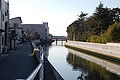 Yana River, Kisarazu
 -
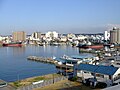
 Umi-hotaru (Sea firefly) Parking Service area and Kisarazu
 -
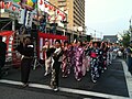 Yassai-Mossai (Sokonoke-Sokonoke) Dancing Event on August 14
 -
 Kisarazu Port Festival (Minato-Matsuri) Fireworks Festival on August15


References
[edit]- ^"Kisarazu city official statistics"(in Japanese). Japan.
- ^abKhí tượng sảnh / bình niên trị ( niên ・ nguyệt ごとの trị ).JMA.RetrievedApril 2,2022.
- ^Quan trắc sử thượng 1~10 vị の trị ( niên gian を thông じての trị ).JMA.RetrievedApril 2,2022.
- ^Kisarazu population statistics
External links
[edit]- Official Website(in Japanese)
| Chiba |
| |||
|---|---|---|---|---|
| Core cities | ||||
| Cities | ||||
| Districts | ||||
| International | |
|---|---|
| National | |
| Geographic | |
| Academics | |