Koboro Station
H45 Koboro Station Tiểu hoảng dịch | |||||||||||
|---|---|---|---|---|---|---|---|---|---|---|---|
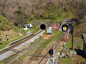
 Full view of the Koboro Station in April 2022 | |||||||||||
| General information | |||||||||||
| Location | Rebunka,Toyoura Town,Abuta District Hokkaido Prefecture Japan | ||||||||||
| Operated by | |||||||||||
| Line(s) | Muroran Main Line | ||||||||||
| Platforms | 2side platforms | ||||||||||
| Tracks | 2 | ||||||||||
| Construction | |||||||||||
| Structure type | At grade | ||||||||||
| Other information | |||||||||||
| Status | Unstaffed | ||||||||||
| Station code | H45 | ||||||||||
| History | |||||||||||
| Opened | 25 September 1943 | ||||||||||
| Services | |||||||||||
| |||||||||||
| |||||||||||
Koboro Station(Tiểu hoảng dịch,Koboro-eki)is a railway station inToyoura, Hokkaido,Japan, operated by theHokkaido Railway Company(JR Hokkaido).
Located in an 80m-wide gap in between two long tunnels in the cliffs alongUchiura Bay,the station has no road access and is known for being the mostsecluded stationin Japan.[1][2]
Lines
[edit]Koboro Station is served by theMuroran Main Line.
Station layout
[edit]The station has twoside platforms,serving one track each. There is no station building or waiting room, only a small maintenance shed. Anouthousewith abio-toiletis available.
-
Platform view forHigashi-Muroran
-
Platform view forOshamambe
-
Name sign
History
[edit]The station originally opened on September 30, 1943 as Koboro Signal Box (Koboro shingōjō). It added apassing loopto the then-single-track lineand served as a point fortoken exchange,increasing line capacity in order to meet a wartime surge in demand — at the time, the Muroran Line as well as theHakodate Main Linehad been pressed into service to transportation coal and other materiel for the ongoingPacific War.Finding a suitable location was difficult, as the track ran through a succession of tunnels in rugged terrain;track duplicationwas also considered as an alternative. Ultimately, it was constructed on a section with gentlergradeas a ″chimney-style signal box″ — an arrangement where stopped trains would remain mostly inside the tunnel, with only the front of the steam locomotive peeking out into the open air to vent smoke. This unusual design was to become a contributing factor in theMuroran Main Line train collisionon March 31, 1947.
Despite its classification as a ′signal box′ rather than a 'station', passengers were allowed to board and disembark. Upon conversion of the line to double-track running, the signal box was made redundant and thus reclassified as Koboro Provisional Stop (Koboro kari-jōkōjō) on October 1, 1967. It was promoted to the status of full station and renamed Koboro Station on April 1, 1987 when JR Hokkaido was established. However, the location of the station was not officially defined by the distance for the purpose of fare calculation until March 10, 1990.[3]
In July 2015, JR Hokkaido suggested that the station may be closed due to high maintenance costs and low ridership;[2]it was later announced that this could happen as early as the end of October.[4]However, the local government of Toyoura sought to keep the station open for tourism purposes, and the closure was deferred while they entered into discussions with JR Hokkaido regarding the possibility of subsidizing the maintenance expenses.[5]In December 2015, JR Hokkaido announced that the station would continue to operate in the coming year with financial and manpower support from the town government; the arrangement would be renewed annually after review and consultation with the local authorities.[6]The most recent renewal took place on 28 March 2022.[1]
In January 2016, tworailway fanswere left stranded at Koboro station when a local train heading for Higashi-Muroran passed through without making its scheduled stop. Due to the station's extreme inaccessibility, JR Hokkaido had to arrange for aHokutoexpress train traveling in the opposite direction (towards Hakodate) to make an unscheduled stop about an hour and a half later to pick up the passengers.[7][8]
Surrounding area
[edit]- Koboro Cave Ruins (Iwaya Kanon) geosite, part ofToya-UsuUNESCO Global Geopark[1][9]
References
[edit]- ^abcNhật bổn nhất の bí cảnh dịch tiểu hoảng dịch について[About Japan's most secluded train station – Koboro Station].Toyoura Town website(in Japanese).Retrieved16 December2021.
- ^abBí cảnh ・ tiểu hoảng dịch, tư tiêu す? “マニアのため duy trì すべきか”[Secluded Koboro Station may disappear: "do we preserve it solely for the sake of the enthusiasts?" ].Doshin Web(in Japanese). Japan: The Hokkaido Shimbun Press. 18 July 2015. Archived fromthe originalon 18 July 2015.
- ^Ishino, Tetsu; et al., eds. (1998).Đình xa tràng 変 thiên đại sự điển quốc thiết ・JR biên[Station Transition Directory – JNR/JR] (in Japanese). Vol. II. Tokyo: JTB Corporation. p. 849.ISBN4-533-02980-9.
- ^Hibino, Yoko (15 August 2015)."Railway buffs bid farewell to lonely Hokkaido station that opened in 1943".The Asahi Shimbun.Archived fromthe originalon 22 August 2015.Retrieved15 August2015.
- ^Bát vân ・ thứu ノ巣, an bình ・ đông truy phân, căn thất ・ hoa tiếu JR, 3 dịch 廃 chỉ を vân đạt tiểu hoảng dịch は tồn 続へ hiệp nghị[JR announces closure of 3 stations (Washinosu in Yakumo, Higashi-Oiwake in Abira, Hanasaki in Nemuro) - Discussions to keep Koboro Station open].Doshin Web(in Japanese). Japan: The Hokkaido Shimbun Press. 2 September 2015. Archived fromthe originalon 2 September 2015.Retrieved2 September2015.
- ^Bình thành 28 niên 3 nguyệt ダイヤ cải chính について[Timetable changes for March 2016](PDF)(Press release) (in Japanese). Japan: JR Hokkaido. 18 December 2015.
- ^"【 nhật bổn nhất の bí cảnh dịch 】 tiểu hoảng dịch を gian vi えて thông quá. Đặc cấp が lâm thời đình xa して thiết đạo ファンを cứu う ( động họa )".ハフポスト(in Japanese). 2016-01-22.Retrieved2024-03-11.
- ^Nhật bỉ dã dung tử (2016-01-21)."“Bí cảnh dịch” に khách trí いてけぼり… Phổ thông liệt xa, quá って dịch thông quá ".Triều nhật tân văn デジタル.Triều nhật tân văn xã. Archived fromthe originalon 2016-12-13.Retrieved2016-12-11.
- ^"Koboro Station – Koboro Cave Route".Toya-Usu UNESCO Global Geopark website.Retrieved16 December2021.


