Kromme Rijn
| Kromme Rijn Crooked Rhine | |
|---|---|
 | |
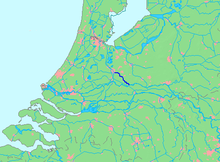
 Location of Kromme Rijn in dark blue. | |
| Location | |
| Country | Netherlands |
| Province | Utrecht |
| Physical characteristics | |
| Source | Nederrijn |
| • location | Wijk bij Duurstede,Utrecht |
| • coordinates | 51°58′15″N5°21′06″E/ 51.97083°N 5.35167°E |
| Mouth | Leidse Rijn |
• location | Utrecht,Utrecht |
• coordinates | 52°04′52.5″N5°07′31″E/ 52.081250°N 5.12528°E |
| Length | 28 km (17 mi) |
TheKromme Rijn(Dutch pronunciation:[ˈkrɔməˈrɛin]) ( "Crooked Rhine", for itsmany bends) is a river in the centralNetherlands.
InRomantimes, this northernmost branch of theRhinedeltawas the main distributary of this major European river. Along its banks the Romans built their frontiercastellapart of theLimes Germanicus.
Since theMiddle Ages,however, the stream lost its importance as it silted up, and eventually it is nearly cut off from theNederrijn-Lekmain artery. Yet it retained the name "Rhine".
The Kromme Rijn splits off the Nederrijn-Lek main artery at the old town ofWijk bij Duurstede(calledDorestadin the early medieval period), after which it twists and turns through theprovinceofUtrecht,past the towns ofCothen,Werkhoven,OdijkandBunnik,and ends in themoatof the city ofUtrecht.
Originally, the city of Utrecht was built by the Romans at afordnear the place where the Kromme Rijn forks into riversVecht(north) andLeidse Rijn(west); the last stretch within thecity walls,however, waschannelisedto form theOudegrachtcanal.Rivers Leidse Rijn and Vecht extend from the city moat and are the continuation of the Kromme Rijn.


