
Kulosaari
Kulosaari
Brändö | |
|---|---|
 Position of Kulosaari within Helsinki | |
| Country | |
| Region | Uusimaa |
| Sub-region | Greater Helsinki |
| Municipality | Helsinki |
| District | Southeastern |
| Area | 1.81 km2(0.70 sq mi) |
| Population (2004) | 3,770 |
| • Density | 2,083/km2(5,390/sq mi) |
| Postal codes | 00570 |
| Subdivision number | 42 |
| Neighbouring subdivisions | Herttoniemenranta Länsi-Herttoniemi Mustikkamaa-Korkeasaari Sörnäinen Tullisaari |
Kulosaari(Swedish:Brändö) is anislandand an East Helsinkisuburb inHelsinki,Finland.It is also the 42ndneighbourhoodof the city. Construction ofvillason the island started in the beginning of the 20th century, and a bridge fromSörnäinenwas opened in 1919. Kulosaari was an independentmunicipalitysince 1922 until 1946, when it was merged to Helsinki.

Kulosaari is home to 3,700 people (2003), and has a size of 1.81 square kilometres (0.70 sq mi). The island is host to both Swedish-speaking and Finnish-speaking primary schools and theKulosaari Secondary School(Kulosaaren Yhteiskoulu, or KSYK) international secondary school, as well as Brändö Gymnasium, agymnasiumforSwedish-speaking Finns.
Tramsserved the island from 1910 to 1951 – before the first bridge was completed, ferries were used to transport the trams. In 1982 Kulosaari got its ownsubway station,an original station of theHelsinki Metro.An important highway calledItäväylä,serving Helsinki's eastern suburbs, goes through the island, cutting it in two halves.
Kulosaari is connected via a short bridge to the adjacent island ofMustikkamaa,which is used for various recreational purposes.[1]


History and Architecture[edit]
The current Finnish name of district, Kulosaari, is relatively young; its Swedish spelling Brändö has been in use since 1808. As early as the 18th century, the island was called Stuguö [lit: cottage island] or Stugulandet [lit: cottage land], based on a cottage owned by a fisherman. The island has long belonged to the lands ofKulosaari Manor,the manor house (designed by architectCarl Ludvig Engel,1810) and grounds of which still exist, though it is situated on the adjacent island.[2]
So-called Brändö Villastad was founded in 1907 by a group of businessmen, architects and engineers outside the city of Helsinki, includingAllan Granfelt.Their aim was to form on 250 acres of the barely inhabited island a town consisting of modern villas for middle-class families.[3]
The architectLars Sonck,who was a member of the company, drew up the town plan for the area in 1909, the town-planning principles of which were inspired by Austrian plannerCamillo Sitte'sinfluential bookStädtebauas well asGarden CityPlanning derived from England, with Sonck striving to give as many house owners as possible direct access to the sea from their plot, while public buildings were placed further inland.[3]In Sonck's first plan, a formal connection was made between the highest point of the island, Vapaamuurarinmäki, marked later by the church bell tower, and the most remarkable natural formation on the island, the lagoon-like inland bay (Gloet or Kluuvi) on the southern seafront of the island. Built between the two was the Ribbinginhovi park allée. The villas and terraced housing built within the plan were designed mainly in accordance with the then prevailingJugendstilarchitecture. The largest buildings built at that time were the Kulosaari Hotel (nowadays Wihuri House, company headquarters), 1917, also by Sonck, and the Domus apartment building (nowadays Brändö Gymnasium school), 1916, by architectJ.S. Siren.Other notable buildings are the Kulosaari Casino, 1915 by Armas Lindgren and the Ribbinginhovi terraced housing, 1920, also by Lindgren.[3]Kulosaari Church,1935, was designed by architectBertel Jungin the Jugendstil style, but the adjacent vast classical-functionalist campanile was designed later by Lindgren.
Nowadays, Kulosaari is also noted for the location of a significant of purpose-built foreign embassy buildings, including those of China, India, Vietnam, Lithuania, Slovakia, Romania, Columbia, Iraq and Iran.
The Relander Square (Relanderinaukio) in Kulosaari was named afterL. K. Relander,thesecond President of Finland,in 1959.[4]
Politics[edit]
Results of the2011 Finnish parliamentary electionin Kulosaari:
- National Coalition Party43.7%
- Swedish People's Party14.5%
- Green League13.7%
- Social Democratic Party9.0%
- True Finns7.4%
- Left Alliance5.4%
- Centre Party3.5%
- Christian Democrats1.5%
Buildings of Kulosaari[edit]
-
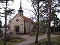 Kulosaari Church, Bertel Jung, 1935.
 -
 Domus apartment building, J.S Sirén, 1916.
 -
 Kulosaari Casino, Armas Lindgren, 1915.
 -
 Former Kulosaari Hotel, Lars Sonck, 1917.
 -
 Ribbinginhovi terraced housing, Armas Lindgren, 1920.
 -
 View of the "Svinhufvudintie" road, exposing low-rise apartment blocks from the 1960s.


References[edit]
- ^"Mustikkamaa".Hel.fi.City of Helsinki.Retrieved8 November2020.
- ^Näkymä Oy,Kulosaaren Kluvin puistoalueet - puistohistoriallinen selvitys,Helsingin kaupunki, 2010.
- ^abcRiitta Nikula,Architecture and Landscape: The Building of Finland,Otava, Helsinki, 1993.
- ^Olavi Terho:Helsingin kadunnimet(in Finnish), p. 199. Helsingin kaupungin julkaisuja 24, 1970, Helsinki.
60°11′N25°01′E/ 60.183°N 25.017°E
| Southern Eteläinen Södra |
|  |
|---|---|---|
| Western Läntinen Västra | ||
| Central Keskinen Mellersta | ||
| Northern Pohjoinen Norra | ||
| Northeastern Koillinen Nordöstra | ||
| Southeastern Kaakkoinen Sydöstra | ||
| Eastern Itäinen Östra | ||
| Östersundom Östersundomin Östersundoms | ||
HelsinkiCityscape | |||||
|---|---|---|---|---|---|
| Buildings |  | ||||
| Places of worship |
| ||||
| Monuments & memorials | |||||
| Parks & gardens | |||||
| Islands | |||||
| City squares | |||||
| Tourist attractions | |||||
| Hotels | |||||
| Museums | |||||
| Performing arts |
| ||||
| Other venues |
| ||||
| Authority control databases:Geographic |
|---|
ThisSouthern Finlandlocation article is astub.You can help Wikipedia byexpanding it. |