
Kumrovec
Kumrovec | |
|---|---|
      | |
 Coat of arms | |
 Kumrovec Location of Kumrovec in Croatia | |
| Coordinates:46°5′8″N15°40′40″E/ 46.08556°N 15.67778°E | |
| Country | |
| County | |
| Government | |
| • Municipal Mayor | Robert Šplajt (HNS) |
| • Council | 11 members |
| Area | |
| •Municipality | 17.5 km2(6.8 sq mi) |
| • Urban | 2.1 km2(0.8 sq mi) |
| Population (2021)[2] | |
| •Municipality | 1,412 |
| • Density | 81/km2(210/sq mi) |
| •Urban | 245 |
| • Urban density | 120/km2(300/sq mi) |
| Time zone | UTC+1(CET) |
| • Summer (DST) | UTC+2(CEST) |
| Website | kumrovec |
Kumrovec(Croatian pronunciation:[kûmroʋet͡s]) is avillagein the northern partCroatia,part ofKrapina-Zagorje County.It sits on theSutlaRiver, along the Croatian-Slovenian border. The Kumrovec municipality has 1,413 residents (2021), but the village itself has only 267 people.[3]The municipality was established on May 6, 1997, after it was split from the municipality ofTuhelj.
Kumrovec is notably the birthplace ofJosip Broz Tito(1892–1980), the president offormer Yugoslavia.The birth house of Tito (built in 1860 as the first brickwork house in the village) features the Memorial Museum of Marshal Tito, opened in 1953. The museum is also important for the local folklore. Next to the house is the bronze standing statue of Marshal Tito (made byAntun Augustinčić,1948). The old part of Kumrovec comprises the Ethnological Museum with 18 village houses, displaying permanent exhibitions of artifacts related to the life and work of Zagorje peasants in the 19th/20th century. The village is small but of great popularity in the former Yugoslavia, owing to the annual celebration ofYouth Dayevery May 25.[4]
Today the major attraction of Kumrovec is the Ethnological Museum Staro Selo (Old Village) Kumrovec with very well preserved village houses from the turn of 19th/20th century. The reconstruction and redecoration of these houses started in 1977. So far 40-odd houses and other farmstead facilities have been restored, which makes Staro Selo the most attractive place of this kind in Croatia. Visitors may see permanent ethnological exhibitions such as theZagorje-style Wedding, the Life of Newly-weds, From Hemp to Linen, Blacksmith's Crafts, Cart-wright's Craft, Pottery, From Grain to Bread, etc.
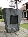
On November 24, 1935, theBrethren of the Croatian Dragonraised a monument to the Croatian anthemLijepa naša domovinoto celebrate its one hundredth anniversary. Kumrovec celebrates this day as its municipal holiday.[5]
History
[edit]In the late 19th and early 20th century, Kumrovec was part ofVaraždin Countyof theKingdom of Croatia-Slavonia.
According to the research of Slovenian historianDaniel Siter,during the initial phase of the German occupation of the Slovene-Croatian territory between May and June 1941, the municipality of Kumrovec was temporarily occupied byNazi Germany,along with other parts of the western outskirts of theCroatian Zagorje(Hum na Sotli,Prišlin, Druškovec, Brezno andLupinjak). For the first few weeks after the occupation in April, the swastika also hung in Kumrovec. The occupied territory of Western Croatian Zagorje (including Kumrovec) was returned to theIndependent State of Croatiain mid-June 1941. At that time, the state and occupation border between Germany and Croatia was finally established along the water line of theSotla river.[6][7]
Culture
[edit]The municipality is home to the cultural organizationKUD Kumrovec.[8]It has two Catholic chapels:Kapela sv. Rokbuilt in 1963 andKapela Majke Božje Snježnebuilt in 1639.[9]
Population
[edit]According to the 2011 census, the municipality had a total population of 1,588 in ten separate settlements:[3]
- Donji Škrnik(pop. 169)
- Dugnjevec(pop. 67)
- Kladnik(pop. 155)
- Kumrovec (pop. 267)
- Podgora(pop. 45)
- Ravno Brezje(pop. 216)
- Razdrto Tuheljsko(pop. 97)
- Razvor(pop. 191)
- Risvica(pop. 277)
- Velinci(pop. 104)
Gallery
[edit]-
 Marshal Tito's birth house
 -
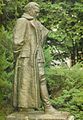 Tito's statue in Kumrovec, made by the sculptorAntun Augustinčić(1900-1979)
 -
 Monument to theCroatian anthem
 -
 Monument to the fallen fighters of theNational Liberation strugglein the area of Kumrovec
 -
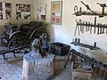 One of the scenes at the Ethnological Museum in Kumrovec
 -
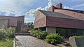 FormerCommunist Party of Yugoslaviapolitical school in Kumrovec.


References
[edit]- ^Register of spatial units of the State Geodetic Administration of the Republic of Croatia.WikidataQ119585703.
- ^"Population by Age and Sex, by Settlements"(xlsx).Census of Population, Households and Dwellings in 2021.Zagreb:Croatian Bureau of Statistics.2022.
- ^ab"Population by Age and Sex, by Settlements, 2011 Census: Kumrovec".Census of Population, Households and Dwellings 2011.Zagreb:Croatian Bureau of Statistics.December 2012.
- ^"Several Thousand Admirers of Tito Celebrate Day of Youth in Kumrovec".Total Croatia News. 21 May 2022.Retrieved15 July2022.
- ^"Kumrovec".tzkzz.hr(in Croatian). Archived fromthe originalon 17 April 2015.Retrieved17 April2015.
- ^Siter, Daniel (2023).Rogaška Slatina pod kljukastim križem: zdravilišče med okupacijo 1941-1945(2nd (supplemented and expanded) ed.). Ljubljana: Alma Mater Europaea - Fakulteta za humanistični študij, Institutum Studiorum Humanitatis, Ljubljana. pp. 3–6, 55–61, 307–322.ISBN978-961-6192-89-7.
- ^Siter, Daniel (2019-08-26)."Reka Sotla kot okupacijska meja med nemškim rajhom in NDH: primer občine Rogaška Slatina".Kronika: časopis za slovensko krajevno zgodovino(Letn. 67, št. 1 (2019)): 141–164.ISSN0023-4923.Retrieved2023-09-20.
- ^"KUD Kumrovec".kumrovec.hr.Retrieved6 September2015.
- ^KumrovecArchivedMarch 27, 2009, at theWayback Machine
Further reading
[edit]- Siter, Daniel[in Slovenian](2019)."Reka Sotla kot okupacijska meja med nemškim rajhom in NDH: primer občine Rogaška Slatina".Kronika: časopis za slovensko krajevno zgodovino(in Slovenian).67(1): 141–164.ISSN0023-4923.COBISS69148258.
- Siter, Daniel[in Slovenian](2023).Rogaška Slatina pod kljukastim križem: Zdravilišče med okupacijo 1941–1945(2 ed.). Ljubljana:Alma Mater Europaea,Institutum Studiorum Humanitatis.ISBN978-961-6192-89-7.COBISS143986691.
External links
[edit]Subdivisions ofKrapina-Zagorje County | ||
|---|---|---|
| Towns |  | |
| Municipalities |
| |
| ||
| Life and politics |
|  |
| Premiership | ||
| Presidency | ||
| Family |
| |
| Legacy | ||
| International | |
|---|---|
| National | |
| Geographic | |
| Other | |