
Lafayette Street
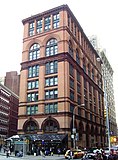
 ThePublic Theater,formerly theAstor Library | |
 Lafayette Street | |
| Width | 50 feet (15 m) |
|---|---|
| North end | East 9th Street |
| South end | Reade Street belowFoley Square |
| East | Centre Street |
| West | Broadway |
Lafayette Streetis a major north–south street inNew York City'sLower Manhattan.It originates at the intersection of Reade Street andCentre Street,one block north ofChambers Street.The one-way street then successively runs throughChinatown,Little Italy,NoLIta,andNoHoand finally, betweenEast 9thandEast 10thstreets, merges withFourth Avenue.A bufferedbike laneruns outside the left traffic lane. North ofSpring Street,Lafayette Street is northbound (uptown)-only; south of Spring Street, Lafayette is southbound (downtown)-only.
The street is named after theMarquis de Lafayette,a French hero of theAmerican Revolutionary War.[1]
History
[edit]Early years (1804-1887)
[edit]


The street originated as a real estate speculation byJohn Jacob Astor,who had bought a large market garden in 1804, for $45,000, and leased part of the site to a Frenchman named Joseph Delacroix, who erected a popular resort and called it "Vauxhall Gardens"after thefamous resort on the edge of London.When the lease expired in 1825, Astor cut a new street through, a 100-foot wide three-block boulevard with no cross streets, which began atAstor Placeand ended atGreat Jones Street[2][3]which he namedLafayette Placeto commemorate the Revolutionary war hero, who hadreturned to a rapturous reception in America the previous year.Lots along both sides of the new street sold briskly, earning Astor many times what he had paid for the land two decades before.[4]The grandest was the terrace of matching marble-frontedGreek Revivalhouses on the west side of the street, called La Grange Terrace when it was built in 1833, but known to New Yorkers as "Colonnade Row"for the two-story order of Corinthian columns that unified its fronts; the nine residences each sold for as much as $30,000; four that remain are the only survivors of the first fashionable residential phase of Lafayette Street, which gained its new name when the city extended the street south in the early 1900s.[1][5]At that time its route was carved from the former Elm Street, Marion Street, and Lafayette Place and connected to Centre Street at the Municipal Building.[6]
Later developments (1888-present)
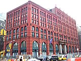
[edit]The change in Lafayette Street's history is epitomized by the construction of theSchermerhorn Buildingin 1888 to replace the Schermerhorn mansion, where Mrs. William Colford Schermerhorn had redecorated the interior to resemble Louis XV's Versailles, it was thought, to give a French-themedcostume ballin 1854 for six hundred New Yorkers,[7]at which theGerman Cotillionwas introduced in America.[8]A sign of changing times, in 1860 the W.C. Schermerhorns moved uptown to 49West 23rd Street.[9]Before long, half of Colonnade Row was demolished to make way for a warehouse forWanamaker's Department Store.Wanamaker's had taken overA.T. Stewart's palatial dry-goods store that occupied the full block between Broadway and Lafayette and9thand10thStreets, and had also built an equally gigantic Annex next door between8thand 9th Streets, with a skywalk connecting the two buildings. The main store burnt down in 1956, but the annex and warehouse buildings remain extant on Lafayette.
Landmarks
[edit]Landmarks along Lafayette Street include:[10]
- TheNew York Mercantile Librarybuilding atAstor Place(George E. Harney,arch., 1891), once the site of theAstor Opera House,now condominiums
- Alamo,a cube-shaped sculpture inAstor Place
- Astor Library(1854), founded by John Jacob Astor, now housingThe Public Theater
- Colonnade Row(1833), four of a series of nineGreek revivalrow houses;theAstor Place Theatreis in one
- TheSchermerhorn Building,built for the Schermerhorns in 1888 to designs byHenry Janeway Hardenbergh,to replace the Schermerhorn mansion.
- 339 Lafayette Street,dubbed the "Peace Pentagon" for the many left-wing organizations which were once headquartered there, including theWar Resisters League
- ThePuck BuildingonEast Houston Street
- TheNew York City Rescue Missionon White Street
- TheFirehouse, Engine Company 31building is located at 87 Lafayette at White Street, built in 1895 byNapoleon LeBrun,now theDowntown Community Television Center(DCTV)
- The Ahrens Building, built byGeorge Henry Griebel,and the City Municipal Court Building on the south side of White Street
- Family Courton Franklin Street
- The Department of Health, Hospitals and Sanitation onLeonard Street
- Federal Plaza, which includes theJacob Javits Federal BuildingonWorth Street
- Foley Square,named afterTammany Hall's "Big Tom" Foley, onPearl Street
- TheSoHo-Cast Iron Historic District Extension[11]
Summer Streets
[edit]In August 2008, theNew York City Department of Transportationclosed Lafayette Street, Park Avenue, and part ofEast 72nd Streetto motor traffic for three Saturdays as part of the "Summer Streets"program to encourage non-motor uses.[12]The program has taken place on the first, second, and third Saturdays of August every year since then.[13]
Transportation
[edit]TheNew York City Subway's4,6,<6>,B,D,F,<F>,and Mtrains intersect at a subway station complex atBleecker Street / Broadway – Lafayette Street.TheIRT Lexington Avenue Line(4,5,6,and<6>trains) runs under Lafayette Street, with stops atCanal Street,Spring Street,Bleecker Street, andAstor Place,[14]as well as a former stop atWorth Street.The southboundM22serves a short segment betweenWorth StreetandChambers Street.
Gallery
[edit]-
 The Cube (AlamobyTony Rosenthal) atAstor Place
 -
 "Clinton Hall", at Astor Place, was the home of theNew York Mercantile Library,and the site of theAstor Opera Housewhere theAstor Place riotof 1849 took place
 -
 The Astor Place Building at 444 Lafayette
 -
 Condominium building at 445 Lafayette
 -
 ThePuck Building,former printing plant forPuckmagazine,was built in stages and designed by Albert Wagner


See also
[edit]
References
[edit]Notes
- ^abMoscow, Henry (1978).The Street Book: An Encyclopedia of Manhattan's Street Names and Their Origins.New York:Hagstrom Company.ISBN978-0-8232-1275-0.,p.67
- ^Harris, Luther S..Around Washington Square: an illustrated history of Greenwich VillageJHU Press, 2003.ISBN9780801873416.p.60
- ^Welch, Rebeccah.New York: A Pictorial CelebrationSterling Publishing, 2007.ISBN9781402723834p.120
- ^Burrows, Edwin G.andWallace, Mike(1999).Gotham: A History of New York City to 1898.New York:Oxford University Press.ISBN0-195-11634-8.,p.448
- ^Presa, Donald G.NoHo Historic District Designation ReportArchived2013-03-26 at theWayback MachineNew York Landmarks Preservation Commission(June 29, 1999) p.17-18
- ^"Lower Manhattan Necrology"onForgottenNY.According to theEncyclopedia of New York City,the street on the south side of Houston west of thePuck Buildingwas called "Elm Place" in 1899 when it was widened, causing the west facade of the building to be moved. Whether this was Marion Street by a new name is unknown. Cf. Friedman, Walter and Opdycke, Sandra. "Puck" inJackson, Kenneth T.,ed. (2010).The Encyclopedia of New York City(2nd ed.). New Haven:Yale University Press.ISBN978-0-300-11465-2.,p.1058
- ^Burrows, Edwin G.andWallace, Mike(1999).Gotham: A History of New York City to 1898.New York:Oxford University Press.ISBN0-195-11634-8.,p.723
- ^Morris, Lloyd R. (1979).Incredible New York: Life and Low Life of Last Hundred Years.London: Hamish Hamilton. pp. 17–19.
- ^Schermerhorn genealogy.
- ^New York SonglinesArchived2009-06-10 at theWayback Machine
- ^Betts, Mary Beth (ed.) (May 11, 2010)"SoHo -Cat Iron Historic District Extension Designation Report"Archived2017-02-04 at theWayback MachineNew York Landmarks Preservation Commission
- ^Neuman, William; Santos, Fernanda (June 17, 2008)."On 3 Days in August, City Will Try No-Car Zone".The New York Times.RetrievedSeptember 6,2018.
- ^Summer Streets
- ^"Subway Map"(PDF).Metropolitan Transportation Authority.September 2021.RetrievedSeptember 17,2021.
Further reading
- Eaton, Walter Prichard“Lafayette Place,” pp. 16–27 (see also pp. 13–4) inHenry Collins Brown,ed.Valentine’s Manual of the City of New York 1917–1918New Series No. 2 (The Old Colony Press, New York, 1917) atInternet Archive
- "The Future Elm Street",The New York Times,January 6, 1895
- Presa, Donald G. et al.NoHo Historic District Designation Report,New York City Landmarks Preservation Commission(June 29, 1999), p. 6–7
External links
[edit]- Lafayette Street Storefronts– photographs of buildings and stores along Lafayette Street.
- New York Songlines: Lafayette Street
