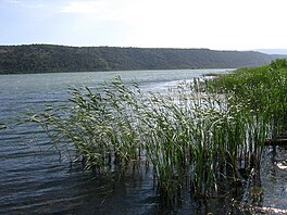
Lake Šas
| Lake Šas Šasko Jezero / Шаско Језеро Liqeni i Shasit | |
|---|---|
 | |
| Location | Ulcinj Municipality |
| Coordinates | 41°58′23″N19°20′02″E/ 41.973°N 19.334°E |
| Primary outflows | Bojana |
| Basincountries | Montenegro |
| Max. length | 3.2 km (2.0 mi) |
| Max. width | 1.5 km (0.93 mi) |
| Surface area | 5.5 km2(2.1 sq mi) |
| Max. depth | 7.8 m (26 ft) |
| Shore length1 | 8.6 km (5.3 mi) |
| 1Shore length isnot a well-defined measure. | |
Lake Šas(Serbian:Шаско jезеро,romanized:Šasko jezero;Albanian:Liqeni i Shasit) is alakelocated north-east ofUlcinj,near the village ofŠas,inMontenegro.It is bordered geographically byBriska Gora(Mali i Brisë) to the southwest, Fraskanjelsko Polje (Këneta e Fraskanjellit) to the east, Ambulsko Brdo (Mali i Amullit) and Šasko Brdo (Mali i Shasit) to the northeast and theBrisko Polje(Fusha e Brisë) to the northwest. Geopolitically,Briska Goralies to the southwest of Lake Šas,Fraskanjellies to the east andAmbulaandŠasto the northeast. The area of this lake is 5.5 km2,it is 3.2 km long and 1.5 km wide. The max depth is 7.8 m. The shore of the lake is about 8.6 km.[1]
It is also known asLittle Lake Skadarbecause it has the same flora and fauna asLake Skadar,which is much larger in size than Lake Šas. In warmer months, the lake is populated with large numbers of different bird species.
Fauna
[edit]List of bird species that have been found in Lake Šas:
- Pelecanus crispus
- Podiceps cristatus
- Tachybaptus ruficollis
- Microcarbo pygmeus
- Egretta garzetta
- Ardeola ralloides
- Platalea leucorodia
- Botaurus stellaris
- Anas platyrhynchos
- Larus cachinnans
- Sterna caspia
- Fulica atra
References
[edit]- ^Jezera i rijeke,Montenegro Travel

