
Landslide


Landslides,also known aslandslips,orrockslides,[1][2][3]are several forms ofmass wastingthat may include a wide range of ground movements, such asrockfalls,mudflows,shallow or deep-seatedslope failuresanddebris flows.[4]Landslides occur in a variety of environments, characterized by either steep or gentle slope gradients, frommountainranges tocoastalcliffsor even underwater,[5]in which case they are calledsubmarine landslides.
Gravityis the primary driving force for a landslide to occur, but there are other factors affectingslope stabilitythat produce specific conditions that make a slope prone to failure. In many cases, the landslide is triggered by a specific event (such as a heavyrainfall,anearthquake,a slope cut to build a road, and many others), although this is not always identifiable.
Landslides are frequently made worse by human development (such asurban sprawl) and resource exploitation (such asmininganddeforestation).Land degradationfrequently leads to less stabilization of soil byvegetation.[6]Additionally, global warming caused byclimate changeand otherhuman impact on the environment,can increase the frequency of natural events (such asextreme weather) which trigger landslides.[7]Landslide mitigationdescribes the policy and practices for reducing the risk of human impacts of landslides, reducing the risk ofnatural disaster.
Causes
[edit]

Landslides occur when the slope (or a portion of it) undergoes some processes that change its condition from stable to unstable. This is essentially due to a decrease in theshear strengthof the slope material, an increase in theshear stressborne by the material, or a combination of the two. A change in the stability of a slope can be caused by a number of factors, acting together or alone. Natural causes of landslides include:
- increase in water content (loss of suction) or saturation by rain water infiltration, snow melting, orglaciersmelting;[8]
- rising ofgroundwateror increase of pore water pressure (e.g. due toaquiferrecharge in rainy seasons, or by rain water infiltration);[9]
- increase of hydrostatic pressure in cracks and fractures;[9][10]
- loss or absence of vertical vegetative structure,soil nutrients,andsoil structure(e.g. after a wildfire);[11]
- erosionof the top of a slope by rivers or seawaves;[12]
- physical and chemicalweathering(e.g. by repeated freezing and thawing, heating and cooling, salt leaking in the groundwater or mineral dissolution);[13][14][15]
- ground shaking caused byearthquakes,which can destabilize the slope directly (e.g., by inducingsoil liquefaction) or weaken the material and cause cracks that will eventually produce a landslide;[10][16][17]
- volcanic eruptions;[18]
- changes in pore fluid composition;[19]
- changes in temperature (seasonal or induced by climate change).[20][21]
Landslides are aggravated by human activities, such as:
- deforestation,cultivationandconstruction;
- vibrationsfrommachineryortraffic;[22]
- blastingandmining;[23]
- earthwork(e.g. by altering the shape of a slope, or imposing new loads);
- in shallowsoils,the removal of deep-rootedvegetationthat bindscolluviumtobedrock;
- agricultural or forestry activities (logging), andurbanization,which change the amount of water infiltrating the soil.
- temporal variation inland useandland cover(LULC): it includes the human abandonment of farming areas, e.g. due to the economic and social transformations which occurred in Europe after the Second World War.Land degradationand extreme rainfall can increase the frequency oferosionand landslide phenomena.[6]
Types
[edit]
Hungr-Leroueil-Picarelli classification
[edit]In traditional usage, the term landslide has at one time or another been used to cover almost all forms ofmass movementof rocks andregolithat the Earth's surface. In 1978, geologist David Varnes noted this imprecise usage and proposed a new, much tighter scheme for the classification of mass movements andsubsidenceprocesses.[24]This scheme was later modified by Cruden and Varnes in 1996,[25]and refined by Hutchinson (1988),[26]Hungr et al. (2001),[27]and finally by Hungr, Leroueil and Picarelli (2014).[4]The classification resulting from the latest update is provided below.
| Type of movement | Rock | Soil |
|---|---|---|
| Fall | Rock/icefall | Boulder/debris/siltfall |
| Topple | Rock block topple | Gravel/sand/silttopple |
| Rock flexural topple | ||
| Slide | Rock rotational slide | Clay/siltrotational slide |
| Rock planar slide | Clay/siltplanar slide | |
| Rock wedge slide | Gravel/sand/debrisslide | |
| Rock compound slide | Clay/siltcompound slide | |
| Rock irregular slide | ||
| Spread | Rock slope spread | Sand/siltliquefaction spread |
| Sensitive clay spread | ||
| Flow | Rock/iceavalanche | Sand/silt/debrisdry flow |
| Sand/silt/debrisflowslide | ||
| Sensitive clay flowslide | ||
| Debris flow | ||
| Mud flow | ||
| Debris flood | ||
| Debris avalanche | ||
| Earthflow | ||
| Peat flow | ||
| Slope deformation | Mountain slope deformation | Soil slope deformation |
| Rock slope deformation | Soil creep | |
| Solifluction | ||
| Note: the words initalicsare placeholders. Use only one. | ||
Under this classification, six types of movement are recognized. Each type can be seen both in rock and in soil. A fall is a movement of isolated blocks or chunks of soil in free-fall. The term topple refers to blocks coming away by rotation from a vertical face. A slide is the movement of a body of material that generally remains intact while moving over one or several inclined surfaces or thin layers of material (also called shear zones) in which large deformations are concentrated. Slides are also sub-classified by the form of the surface(s) or shear zone(s) on which movement happens. The planes may be broadly parallel to the surface ( "planar slides" ) or spoon-shaped ( "rotational slides" ). Slides can occur catastrophically, but movement on the surface can also be gradual and progressive. Spreads are a form of subsidence, in which a layer of material cracks, opens up, and expands laterally. Flows are the movement of fluidised material, which can be both dry or rich in water (such as in mud flows). Flows can move imperceptibly for years, or accelerate rapidly and cause disasters. Slope deformations are slow, distributed movements that can affect entire mountain slopes or portions of it. Some landslides are complex in the sense that they feature different movement types in different portions of the moving body, or they evolve from one movement type to another over time. For example, a landslide can initiate as a rock fall or topple and then, as the blocks disintegrate upon the impact, transform into a debris slide or flow. An avalanching effect can also be present, in which the moving mass entrains additional material along its path.
Flows
[edit]Slope material that becomessaturatedwith water may produce adebris flowormud flow.However, also dry debris can exhibit flow-like movement.[28]Flowing debris or mud may pick up trees, houses and cars, and block bridges and rivers causingfloodingalong its path. This phenomenon is particularly hazardous inalpineareas, where narrow gorges and steep valleys are conducive of faster flows. Debris and mud flows may initiate on the slopes or result from the fluidization of landslide material as it gains speed or incorporates further debris and water along its path. River blockages as the flow reaches a main stream can generate temporary dams. As the impoundments fail, a domino effect may be created, with a remarkable growth in the volume of the flowing mass, and in its destructive power.


Anearthflowis the downslope movement of mostly fine-grained material. Earthflows can move at speeds within a very wide range, from as low as 1 mm/yr[13][14]to many km/h. Though these are a lot likemudflows,overall they are more slow-moving and are covered with solid material carried along by the flow from within. Clay, fine sand and silt, and fine-grained, pyroclastic material are all susceptible to earthflows. These flows are usually controlled by the pore water pressures within the mass, which should be high enough to produce a low shearing resistance. On the slopes, some earthflow may be recognized by their elongated shape, with one or more lobes at their toes. As these lobes spread out, drainage of the mass increases and the margins dry out, lowering the overall velocity of the flow. This process also causes the flow to thicken. Earthflows occur more often during periods of high precipitation, which saturates the ground and builds up water pressures. However, earthflows that keep advancing also during dry seasons are not uncommon. Fissures may develop during the movement of clayey materials, which facilitate the intrusion of water into the moving mass and produce faster responses to precipitation.[29]
A rock avalanche, sometimes referred to assturzstrom,is a large and fast-moving landslide of the flow type. It is rarer than other types of landslides but it is often very destructive. It exhibits typically a long runout, flowing very far over a low-angle, flat, or even slightly uphill terrain. The mechanisms favoring the long runout can be different, but they typically result in the weakening of the sliding mass as the speed increases.[30][31][32]The causes of this weakening are not completely understood. Especially for the largest landslides, it may involve the very quick heating of the shear zone due to friction, which may even cause the water that is present to vaporize and build up a large pressure, producing a sort of hovercraft effect.[33]In some cases, the very high temperature may even cause some of the minerals to melt.[34]During the movement, the rock in the shear zone may also be finely ground, producing a nanometer-size mineral powder that may act as a lubricant, reducing the resistance to motion and promoting larger speeds and longer runouts.[35]The weakening mechanisms in large rock avalanches are similar to those occurring in seismic faults.[32]
Slides
[edit]Slides can occur in any rock or soil material and are characterized by the movement of a mass over a planar or curvilinear surface or shear zone.
A debris slide is a type of slide characterized by the chaotic movement of material mixed with water and/or ice. It is usually triggered by the saturation of thickly vegetated slopes which results in an incoherent mixture of broken timber, smaller vegetation and other debris.[29]Debris flows and avalanches differ from debris slides because their movement is fluid-like and generally much more rapid. This is usually a result of lower shear resistances and steeper slopes. Typically, debris slides start with the detachment of large rock fragments high on the slopes, which break apart as they descend.
Clay and silt slides are usually slow but can experience episodic acceleration in response to heavy rainfall or rapid snowmelt. They are often seen on gentle slopes and move over planar surfaces, such as over the underlying bedrock. Failure surfaces can also form within the clay or silt layer itself, and they usually have concave shapes, resulting in rotational slides
Shallow and deep-seated landslides
[edit]
Slope failure mechanisms often contain large uncertainties and could be significantly affected by heterogeneity of soil properties.[36]A landslide in which the sliding surface is located within thesoilmantle orweatheredbedrock(typically to a depth from few decimeters to some meters) is called a shallow landslide. Debris slides anddebris flowsare usually shallow. Shallow landslides can often happen in areas that have slopes with high permeable soils on top of low permeable soils. The low permeable soil traps the water in the shallower soil generating high water pressures. As the top soil is filled with water, it can become unstable and slide downslope.


Deep-seated landslides are those in which the sliding surface is mostly deeply located, for instance well below the maximum rooting depth of trees. They usually involve deepregolith,weathered rock, and/orbedrockand include large slope failures associated with translational, rotational, or complex movements.[37]They tend to form along a plane of weakness such as afaultorbedding plane.They can be visually identified by concavescarpsat the top and steep areas at the toe.[38]Deep-seated landslides also shapelandscapesover geological timescales and produce sediment that strongly alters the course offluvial streams.[39]
Related phenomena
[edit]- Anavalanche,similar in mechanism to a landslide, involves a large amount of ice, snow and rock falling quickly down the side of a mountain.
- Apyroclastic flowis caused by a collapsing cloud of hotash,gas and rocks from a volcanic explosion that moves rapidly down an eruptingvolcano.
- Extreme precipitation and flow can causegully formationin flatter environments not susceptible to landslides.
Resulting tsunamis
[edit]Landslides that occur undersea, or have impact into water e.g. significant rockfall orvolcanic collapseinto the sea,[40]can generatetsunamis.Massive landslides can also generatemegatsunamis,which are usually hundreds of meters high. In 1958, one suchtsunamioccurred inLituya Bayin Alaska.[41][42]
Landslide prediction mapping
[edit]Landslide hazard analysis and mapping can provide useful information for catastrophic loss reduction, and assist in the development of guidelines for sustainableland-use planning.The analysis is used to identify the factors that are related to landslides, estimate the relative contribution of factors causing slope failures, establish a relation between the factors and landslides, and to predict the landslide hazard in the future based on such a relationship.[43]The factors that have been used for landslide hazard analysis can usually be grouped intogeomorphology,geology,land use/land cover, andhydrogeology.Since many factors are considered for landslide hazard mapping,GISis an appropriate tool because it has functions of collection, storage, manipulation, display, and analysis of large amounts of spatially referenced data which can be handled fast and effectively.[44]Cardenas reported evidence on the exhaustive use of GIS in conjunction of uncertainty modelling tools for landslide mapping.[45][46]Remote sensingtechniques are also highly employed for landslide hazard assessment and analysis. Before and after aerial photographs and satellite imagery are used to gather landslide characteristics, like distribution and classification, and factors like slope,lithology,and land use/land cover to be used to help predict future events.[47]Before and after imagery also helps to reveal how the landscape changed after an event, what may have triggered the landslide, and shows the process of regeneration and recovery.[48]
Using satellite imagery in combination with GIS and on-the-ground studies, it is possible to generate maps of likely occurrences of future landslides.[49]Such maps should show the locations of previous events as well as clearly indicate the probable locations of future events. In general, to predict landslides, one must assume that their occurrence is determined by certain geologic factors, and that future landslides will occur under the same conditions as past events.[50]Therefore, it is necessary to establish a relationship between the geomorphologic conditions in which the past events took place and the expected future conditions.[51]
Natural disastersare a dramatic example of people living in conflict with the environment. Early predictions and warnings are essential for the reduction of property damage and loss of life. Because landslides occur frequently and can represent some of the most destructive forces on earth, it is imperative to have a good understanding as to what causes them and how people can either help prevent them from occurring or simply avoid them when they do occur.Sustainable land managementand development is also an essential key to reducing the negative impacts felt by landslides.

GIS offers a superior method for landslide analysis because it allows one to capture, store, manipulate, analyze, and display large amounts of data quickly and effectively. Because so many variables are involved, it is important to be able to overlay the many layers of data to develop a full and accurate portrayal of what is taking place on the Earth's surface. Researchers need to know which variables are the most important factors that trigger landslides in any given location. Using GIS, extremely detailed maps can be generated to show past events and likely future events which have the potential to save lives, property, and money.
Since the ‘90s, GIS have been also successfully used in conjunction todecision support systems,to show on a map real-time risk evaluations based on monitoring data gathered in the area of theVal Pola disaster(Italy).[53]
-
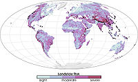 Global landslide risks
 -
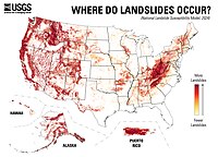 2024 United States landslide risk map
 -
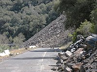 Ferguson SlideonCalifornia State Route 140in June 2006
 -
 Trackside rock slide detector on theUPRRSierra grade nearColfax, CA


Prehistoric landslides
[edit]
- Storegga Slide,some 8,000 years ago off the western coast ofNorway.Caused massivetsunamisinDoggerlandand other areas connected to theNorth Sea.A total volume of 3,500 km3(840 cu mi) debris was involved; comparable to a 34 m (112 ft) thick area the size of Iceland. The landslide is thought to be among the largest in history.[citation needed]
- Landslide which movedHeart Mountainto its current location, the largest continental landslide discovered so far. In the 48 million years since the slide occurred, erosion has removed most of the portion of the slide.
- Flims Rockslide,about 12 km3(2.9 cu mi), Switzerland, some 10,000 years ago in post-glacialPleistocene/Holocene,the largest so far described in the Alps and on dry land that can be easily identified in a modestly eroded state.[54]
- The landslide around 200 BC which formedLake Waikaremoanaon theNorth Islandof New Zealand, where a large block of the Ngamoko Range slid and dammed a gorge of Waikaretaheke River, forming a natural reservoir up to 256 metres (840 ft) deep.
- Cheekye Fan,British Columbia,Canada, about 25 km2(9.7 sq mi),Late Pleistocenein age.
- The Manang-Braga rock avalanche/debris flow may have formed Marsyangdi Valley in the Annapurna Region,Nepal,during an interstadial period belonging to the last glacial period.[55]Over 15 km3(3.6 cu mi) of material are estimated to have been moved in the single event, making it one of the largest continental landslides.[citation needed]
- Tsergo Ri landslide,a massive slope failure 60 km (37 mi) north of Kathmandu, Nepal, involving an estimated 10 to 15 km3(2.4 to 3.6 cu mi).[56]Prior to this landslide the mountain may have been the world's 15th mountain above 8,000 m (26,247 ft).
Historical landslides
[edit]- The1806 Goldau landslideon 2 September 1806
- The Cap DiamantQuébec rockslideon 19 September 1889
- Frank Slide,Turtle Mountain,Alberta,Canada, on 29 April 1903
- Khait landslide,Khait,Tajikistan,Soviet Union, on 10 July 1949
- Amagnitude 7.5 earthquakein Yellowstone Park (17 August 1959) caused a landslide that blocked the Madison River, and created Quake Lake.
- Monte Toclandslide (260 million cubic metres; 9.2 billion cubic feet) falling into theVajont Dambasin in Italy, causing amegatsunamiand about 2000 deaths, on 9 October 1963
- Hope Slidelandslide (46 million cubic metres; 1.6 billion cubic feet) nearHope, British Columbiaon 9 January 1965.[57]
- The 1966Aberfan disaster
- Tuve landslideinGothenburg,Sweden on 30 November 1977.
- The1979 Abbotsford landslip,Dunedin,New Zealand on 8 August 1979.
- Theeruption of Mount St. Helens(18 May 1980) caused an enormous landslide when the top 1300 feet of the volcano suddenly gave way.
- Val Pola landslideduringValtellina disaster(1987) Italy
- Thredbo landslide,Australia on 30 July 1997, destroyed hostel.
- Vargas mudslides,due to heavy rains inVargas State,Venezuela,in December, 1999, causing tens of thousands of deaths.
- 2005 La Conchita landslidein Ventura,Californiacausing 10 deaths.
- 2006 Southern Leyte mudslideinSaint Bernard,Southern Leyte,causing 1,126 deaths and buried the village of Guinsaugon.
- 2007 Chittagong mudslide,inChittagong,Bangladesh,on 11 June 2007.
- 2008 Cairo landslideon 6 September 2008.
- The 2009 Peloritani Mountainsdisaster caused 37 deaths, on October 1.[58]
- The2010 Uganda landslidecaused over 100 deaths following heavy rain inBududaregion.
- Zhouqu county mudslideinGansu,China on 8 August 2010.[59]
- Devil's Slide,an ongoing landslide inSan Mateo County, California
- 2011 Rio de Janeiro landslideinRio de Janeiro,Brazil on 11 January 2011, causing 610 deaths.[60]
- 2014 Pune landslide,inPune,India.
- 2014 Oso mudslide,inOso, Washington
- 2017 Mocoa landslide,inMocoa,Colombia
- 2022 Ischia landslide
- 2024 Gofa landslides,inGofa,Ethiopia
- 2024 Wayanad landslides,inWayanad,Kerala,India
Extraterrestrial landslides
[edit]Evidence of past landslides has been detected on many bodies in the solar system, but since most observations are made by probes that only observe for a limited time and most bodies in the solar system appear to be geologically inactive not many landslides are known to have happened in recent times. Both Venus and Mars have been subject to long-term mapping by orbiting satellites, and examples of landslides have been observed on both planets.
-
 Before and after radar images of a landslide on Venus. In the center of the image on the right, the new landslide, a bright, flow-like area, can be seen extending to the left of a bright fracture. 1990 image.
 -
 Landslide in progress on Mars, 2008-02-19


Landslide mitigation
[edit]Landslide mitigationrefers to several human-made activities onslopeswith the goal of lessening the effect of landslides. Landslides can be triggered by many, sometimesconcomitantcauses. In addition to shallowerosionor reduction ofshear strengthcaused byseasonal rainfall,landslides may be triggered byanthropicactivities, such as adding excessive weight above the slope, digging at mid-slope or at the foot of the slope. Often, individual phenomena join to generate instability over time, which often does not allow a reconstruction of the evolution of a particular landslide. Therefore, landslide hazard mitigation measures are not generally classified according to the phenomenon that might cause a landslide.[61]Instead, they are classified by the sort ofslope stabilizationmethod used:
- Geometric methods, in which the geometry of the hillside is changed (in general the slope);
- Hydrogeologicalmethods, in which an attempt is made to lower the groundwater level or to reduce the water content of the material
- Chemical and mechanical methods, in which attempts are made to increase the shear strength of the unstable mass or to introduce active external forces (e.g.anchors,rock or groundnailing) or passive (e.g. structural wells, piles or reinforced ground) to counteract the destabilizing forces.
Climate-change impact on landslides
[edit]Climate-change impact on temperature, both average rainfall and rainfall extremes, and evapotranspiration may affect landslide distribution, frequency and intensity (62). However, this impact shows strong variability in different areas (63). Therefore, the effects of climate change on landslides need to be studied on a regional scale. Climate change can have both positive and negative impacts on landslides Temperature rise may increase evapotranspiration, leading to a reduction in soil moisture and stimulate vegetation growth, also due to a CO2 increase in the atmosphere. Both effects may reduce landslides in some conditions. On the other side, temperature rise causes an increase of landslides due to
- the acceleration of snowmelt and an increase of rain on snow during spring, leading to strong infiltration events (64).
- Permafrost degradation that reduces the cohesion of soils and rock masses due to the loss of interstitial ice (65). This mainly occurs at high elevation.
- Glacier retreat that has the dual effect of relieving mountain slopes and increasing their steepness.
Since the average precipitation is expected to decrease or increase regionally (63), rainfall induced landslides may change accordingly, due to changes in infiltration, groundwater levels and river bank erosion. Weather extremes are expected to increase due to climate change including heavy precipitation (63). This yields negative effects on landslides due to focused infiltration in soil and rock (66) and an increase of runoff events, which may trigger debris flows.
See also
[edit]References
[edit]- ^"Landslide synonyms".thesaurus.com.Roget's 21st Century Thesaurus. 2013.Archivedfrom the original on 24 September 2020.Retrieved16 March2018.
- ^McGraw-Hill Encyclopedia of Science & Technology, 11th Edition,ISBN9780071778343,2012
- ^"USGS factsheet, Landslide Types and Processes, 2004".Archivedfrom the original on 2020-10-04.Retrieved2020-08-28.
- ^abHungr, Oldrich; Leroueil, Serge; Picarelli, Luciano (2014-04-01)."The Varnes classification of landslide types, an update".Landslides.11(2): 167–194.Bibcode:2014Lands..11..167H.doi:10.1007/s10346-013-0436-y.ISSN1612-5118.S2CID38328696.
- ^Haflidason, Haflidi; Sejrup, Hans Petter; Nygård, Atle; Mienert, Jurgen; Bryn, Petter; Lien, Reidar; Forsberg, Carl Fredrik; Berg, Kjell; Masson, Doug (2004-12-15)."The Storegga Slide: architecture, geometry and slide development".Marine Geology.COSTA - Continental Slope Stability.213(1): 201–234.Bibcode:2004MGeol.213..201H.doi:10.1016/j.margeo.2004.10.007.ISSN0025-3227.
- ^abGiacomo Pepe; Andrea Mandarino; Emanuele Raso; Patrizio Scarpellini; Pierluigi Brandolini; Andrea Cevasco (2019)."Investigation on Farmland Abandonment of Terraced Slopes Using Multitemporal Data Sources Comparison and Its Implication on Hydro-Geomorphological Processes".Water.8(11).MDPI:1552.doi:10.3390/w11081552.hdl:11567/968956.ISSN2073-4441.OCLC8206777258.,at the introductory section.
- ^Merzdorf, Jessica."Climate Change Could Trigger More Landslides in High Mountain Asia".Climate Change: Vital Signs of the Planet.NASA's Goddard Space Flight Center.Archivedfrom the original on 2023-02-04.Retrieved2023-02-04.
- ^Subramanian, S. Siva; Fan, X.; Yunus, A. P.; Asch, T. van; Scaringi, G.; Xu, Q.; Dai, L.; Ishikawa, T.; Huang, R. (2020)."A Sequentially Coupled Catchment-Scale Numerical Model for Snowmelt-Induced Soil Slope Instabilities".Journal of Geophysical Research: Earth Surface.125(5): e2019JF005468.Bibcode:2020JGRF..12505468S.doi:10.1029/2019JF005468.ISSN2169-9011.S2CID218825257.Archivedfrom the original on 2022-03-06.Retrieved2021-02-23.
- ^abHu, Wei; Scaringi, Gianvito; Xu, Qiang; Van Asch, Theo W. J. (2018-04-10). "Suction and rate-dependent behaviour of a shear-zone soil from a landslide in a gently-inclined mudstone-sandstone sequence in the Sichuan basin, China".Engineering Geology.237:1–11.Bibcode:2018EngGe.237....1H.doi:10.1016/j.enggeo.2018.02.005.ISSN0013-7952.
- ^abFan, Xuanmei; Xu, Qiang; Scaringi, Gianvito (2017-12-01). "Failure mechanism and kinematics of the deadly June 24th 2017 Xinmo landslide, Maoxian, Sichuan, China".Landslides.14(6): 2129–2146.Bibcode:2017Lands..14.2129F.doi:10.1007/s10346-017-0907-7.ISSN1612-5118.S2CID133681894.
- ^Rengers, Francis K.; McGuire, Luke A.; Oakley, Nina S.; Kean, Jason W.; Staley, Dennis M.; Tang, Hui (2020-11-01)."Landslides after wildfire: initiation, magnitude, and mobility".Landslides.17(11): 2631–2641.Bibcode:2020Lands..17.2631R.doi:10.1007/s10346-020-01506-3.ISSN1612-5118.S2CID221110680.
- ^Edil, T. B.; Vallejo, L. E. (1980-07-01)."Mechanics of coastal landslides and the influence of slope parameters".Engineering Geology.Special Issue Mechanics of Landslides and Slope Stability.16(1): 83–96.Bibcode:1980EngGe..16...83E.doi:10.1016/0013-7952(80)90009-5.ISSN0013-7952.
- ^abcDi Maio, Caterina; Vassallo, Roberto; Scaringi, Gianvito; De Rosa, Jacopo; Pontolillo, Dario Michele; Maria Grimaldi, Giuseppe (2017-11-01)."Monitoring and analysis of an earthflow in tectonized clay shales and study of a remedial intervention by KCl wells".Rivista Italiana di Geotecnica.51(3): 48–63.doi:10.19199/2017.3.0557-1405.048.Archivedfrom the original on 2021-04-03.Retrieved2018-05-26.
- ^abDi Maio, Caterina; Scaringi, Gianvito; Vassallo, R (2014-01-01)."Residual strength and creep behaviour on the slip surface of specimens of a landslide in marine origin clay shales: influence of pore fluid composition".Landslides.12(4): 657–667.doi:10.1007/s10346-014-0511-z.S2CID127489377.Archivedfrom the original on 2021-03-30.Retrieved2018-05-26.
- ^Fan, Xuanmei; Xu, Qiang; Scaringi, Gianvito; Li, Shu; Peng, Dalei (2017-10-13)."A chemo-mechanical insight into the failure mechanism of frequently occurred landslides in the Loess Plateau, Gansu Province, China".Engineering Geology.228:337–345.Bibcode:2017EngGe.228..337F.doi:10.1016/j.enggeo.2017.09.003.ISSN0013-7952.
- ^Fan, Xuanmei; Scaringi, Gianvito; Domènech, Guillem; Yang, Fan; Guo, Xiaojun; Dai, Lanxin; He, Chaoyang; Xu, Qiang; Huang, Runqiu (2019-01-09)."Two multi-temporal datasets that track the enhanced landsliding after the 2008 Wenchuan earthquake".Earth System Science Data.11(1): 35–55.Bibcode:2019ESSD...11...35F.doi:10.5194/essd-11-35-2019.ISSN1866-3508.Archivedfrom the original on 2020-03-04.Retrieved2019-01-09.
- ^Fan, Xuanmei; Xu, Qiang; Scaringi, Gianvito (2018-01-26)."Brief communication: Post-seismic landslides, the tough lesson of a catastrophe".Natural Hazards and Earth System Sciences.18(1): 397–403.Bibcode:2018NHESS..18..397F.doi:10.5194/nhess-18-397-2018.ISSN1561-8633.
- ^Watt, Sebastian F.L.; Talling, Peter J.; Hunt, James E. (2014)."New Insights into the Emplacement Dynamics of Volcanic Island Landslides".Oceanography.27(2): 46–57.doi:10.5670/oceanog.2014.39.ISSN1042-8275.JSTOR24862154.S2CID55516702.
- ^Di Maio, C.; Scaringi, G. (2016-01-18)."Shear displacements induced by decrease in pore solution concentration on a pre-existing slip surface".Engineering Geology.200:1–9.Bibcode:2016EngGe.200....1D.doi:10.1016/j.enggeo.2015.11.007.ISSN0013-7952.
- ^Scaringi, Gianvito; Loche, Marco (2022-03-15)."A thermo-hydro-mechanical approach to soil slope stability under climate change".Geomorphology.401:108108.Bibcode:2022Geomo.40108108S.doi:10.1016/j.geomorph.2022.108108.ISSN0169-555X.S2CID245941223.
- ^Shibasaki, Tatsuya; Matsuura, Sumio; Okamoto, Takashi (2016-07-16)."Experimental evidence for shallow, slow-moving landslides activated by a decrease in ground temperature: Landslides Affected by Ground Temperature".Geophysical Research Letters.43(13): 6975–6984.doi:10.1002/2016GL069604.S2CID132940118.
- ^Laimer, Hans Jörg (2017-05-18)."Anthropogenically induced landslides – A challenge for railway infrastructure in mountainous regions".Engineering Geology.222:92–101.Bibcode:2017EngGe.222...92L.doi:10.1016/j.enggeo.2017.03.015.ISSN0013-7952.
- ^Fan, Xuanmei; Xu, Qiang; Scaringi, Gianvito (2018-10-24). "The" long "runout rock avalanche in Pusa, China, on 28 August 2017: a preliminary report".Landslides.16:139–154.doi:10.1007/s10346-018-1084-z.ISSN1612-5118.S2CID133852769.
- ^Varnes D. J., Slope movement types and processes. In: Schuster R. L. & Krizek R. J. Ed., Landslides, analysis and control. Transportation Research Board Sp. Rep. No. 176, Nat. Acad. oi Sciences, pp. 11–33, 1978.
- ^Cruden, David M., and David J. Varnes. "Landslides: investigation and mitigation. Chapter 3-Landslide types and processes." Transportation research board special report 247 (1996).
- ^Hutchinson, J. N. "General report: morphological and geotechnical parameters of landslides in relation to geology and hydrogeology." International symposium on landslides. 5. 1988.
- ^Hungr O, Evans SG, Bovis M, and Hutchinson JN (2001) Review of the classification of landslides of the flow type. Environmental and Engineering Geoscience VII, 221-238.
- ^Iverson, Richard M. (1997)."The physics of debris flows".Reviews of Geophysics.35(3): 245–296.Bibcode:1997RvGeo..35..245I.doi:10.1029/97RG00426.ISSN1944-9208.S2CID15955986.
- ^abEasterbrook, Don J. (1999).Surface Processes and Landforms.Upper Saddle River:Prentice-Hall.ISBN978-0-13-860958-0.
- ^Hu, Wei; Scaringi, Gianvito; Xu, Qiang; Huang, Runqiu (2018-06-05)."Internal erosion controls failure and runout of loose granular deposits: Evidence from flume tests and implications for post-seismic slope healing".Geophysical Research Letters.45(11): 5518.Bibcode:2018GeoRL..45.5518H.doi:10.1029/2018GL078030.S2CID135013342.
- ^Hu, Wei; Xu, Qiang; Wang, Gonghui; Scaringi, Gianvito; McSaveney, Mauri; Hicher, Pierre-Yves (2017-10-31)."Shear Resistance Variations in Experimentally Sheared Mudstone Granules: A Possible Shear-Thinning and Thixotropic Mechanism".Geophysical Research Letters.44(21): 11, 040.Bibcode:2017GeoRL..4411040H.doi:10.1002/2017GL075261.S2CID135078422.
- ^abScaringi, Gianvito; Hu, Wei; Xu, Qiang; Huang, Runqiu (2017-12-20)."Shear-Rate-Dependent Behavior of Clayey Bimaterial Interfaces at Landslide Stress Levels".Geophysical Research Letters.45(2): 766.Bibcode:2018GeoRL..45..766S.doi:10.1002/2017GL076214.
- ^Deng, Yu; Yan, Shuaixing; Scaringi, Gianvito; Liu, Wei; He, Siming (2020)."An Empirical Power Density-Based Friction Law and Its Implications for Coherent Landslide Mobility".Geophysical Research Letters.47(11): e2020GL087581.Bibcode:2020GeoRL..4787581D.doi:10.1029/2020GL087581.ISSN1944-8007.S2CID219437216.Archivedfrom the original on 2022-03-06.Retrieved2021-02-23.
- ^Deng, Yu; He, Siming; Scaringi, Gianvito; Lei, Xiaoqin (2020)."Mineralogical Analysis of Selective Melting in Partially Coherent Rockslides: Bridging Solid and Molten Friction".Journal of Geophysical Research: Solid Earth.125(8): e2020JB019453.Bibcode:2020JGRB..12519453D.doi:10.1029/2020JB019453.ISSN2169-9356.S2CID225509252.Archivedfrom the original on 2021-10-12.Retrieved2021-02-23.
- ^Rowe, Christie D.; Lamothe, Kelsey; Rempe, Marieke; Andrews, Mark; Mitchell, Thomas M.; Di Toro, Giulio; White, Joseph Clancy; Aretusini, Stefano (2019-01-18)."Earthquake lubrication and healing explained by amorphous nanosilica".Nature Communications.10(1): 320.Bibcode:2019NatCo..10..320R.doi:10.1038/s41467-018-08238-y.ISSN2041-1723.PMC6338773.PMID30659201.
- ^Liu, Xin; Wang, Yu; Li, Dian-Qing (2019)."Investigation of slope failure mode evolution during large deformation in spatially variable soils by random limit equilibrium and material point methods".Computers and Geotechnics.111:301–312.Bibcode:2019CGeot.111..301L.doi:10.1016/j.compgeo.2019.03.022.S2CID145994705.Archivedfrom the original on 2022-08-08.Retrieved2023-04-10.
- ^Liu, Xin; Wang, Yu; Li, Dian-Qing (2020)."Numerical simulation of the 1995 rainfall-induced Fei Tsui Road landslide in Hong Kong: new insights from hydro-mechanically coupled material point method".Landslides.17(12): 2755–2775.Bibcode:2020Lands..17.2755L.doi:10.1007/s10346-020-01442-2.ISSN1612-510X.S2CID219948261.
- ^Johnson, B.F. (June 2010)."Slippery slopes".Earth magazine.pp. 48–55.Archivedfrom the original on 2014-02-22.Retrieved2013-08-28.
- ^Campforts, B (2022)."The Art of Landslides: How Stochastic Mass Wasting Shapes Topography and Influences Landscape Dynamics".Journal of Geophysical Research: Earth Surface.127(8): 1–23.Bibcode:2022JGRF..12706745C.doi:10.1029/2022JF006745.
- ^"Ancient Volcano Collapse Caused A Tsunami With An 800-Foot Wave".Popular Science.Archivedfrom the original on 2017-08-29.Retrieved2017-10-20.
- ^Le Bas, T.P. (2007), "Slope Failures on the Flanks of Southern Cape Verde Islands", in Lykousis, Vasilios (ed.),Submarine mass movements and their consequences: 3rd international symposium,Springer,ISBN978-1-4020-6511-8
- ^Mitchell, N (2003)."Susceptibility of mid-ocean ridge volcanic islands and seamounts to large scale landsliding".Journal of Geophysical Research.108(B8): 1–23.Bibcode:2003JGRB..108.2397M.doi:10.1029/2002jb001997.
- ^Chen, Zhaohua; Wang, Jinfei (2007). "Landslide hazard mapping using logistic regression model in Mackenzie Valley, Canada".Natural Hazards.42(1): 75–89.Bibcode:2007NatHa..42...75C.doi:10.1007/s11069-006-9061-6.S2CID128608263.
- ^Clerici, A; Perego, S; Tellini, C; Vescovi, P (2002). "A procedure for landslide susceptibility zonation by the conditional analysis method1".Geomorphology.48(4): 349–364.Bibcode:2002Geomo..48..349C.doi:10.1016/S0169-555X(02)00079-X.
- ^Cardenas, IC (2008)."Landslide susceptibility assessment using Fuzzy Sets, Possibility Theory and Theory of Evidence. Estimación de la susceptibilidad ante deslizamientos: aplicación de conjuntos difusos y las teorías de la posibilidad y de la evidencia".Ingenieria e Investigación.28(1).
- ^Cardenas, IC (2008)."Non-parametric modeling of rainfall in Manizales City (Colombia) using multinomial probability and imprecise probabilities. Modelación no paramétrica de lluvias para la ciudad de Manizales, Colombia: una aplicación de modelos multinomiales de probabilidad y de probabilidades imprecisas".Ingenieria e Investigación.28(2).
- ^Metternicht, G;Hurni, L; Gogu, R (2005). "Remote sensing of landslides: An analysis of the potential contribution to geo-spatial systems for hazard assessment in mountainous environments".Remote Sensing of Environment.98(2–3): 284–303.Bibcode:2005RSEnv..98..284M.doi:10.1016/j.rse.2005.08.004.
- ^De La Ville, Noemi; Chumaceiro Diaz, Alejandro; Ramirez, Denisse (2002)."Remote Sensing and GIS Technologies as Tools to Support Sustainable Management of Areas Devastated by Landslides"(PDF).Environment, Development and Sustainability.4(2): 221–229.doi:10.1023/A:1020835932757.S2CID152358230.Archived(PDF)from the original on 2022-10-09.
- ^Fabbri, Andrea G.; Chung, Chang-Jo F.; Cendrero, Antonio; Remondo, Juan (2003). "Is Prediction of Future Landslides Possible with a GIS?".Natural Hazards.30(3): 487–503.Bibcode:2003NatHa..30..487F.doi:10.1023/B:NHAZ.0000007282.62071.75.S2CID129661820.
- ^Lee, S; Talib, Jasmi Abdul (2005). "Probabilistic landslide susceptibility and factor effect analysis".Environmental Geology.47(7): 982–990.doi:10.1007/s00254-005-1228-z.S2CID128534998.
- ^Ohlmacher, G (2003). "Using multiple logistic regression and GIS technology to predict landslide hazard in northeast Kansas, USA".Engineering Geology.69(3–4): 331–343.Bibcode:2003EngGe..69..331O.doi:10.1016/S0013-7952(03)00069-3.
- ^Rose, Nick D.; Hunger, Oldrich (17 February 2006)."Forecasting potential slope failure in open pit mines"(PDF).Journal of Rock Mechanics & Mining Sciences.Archived fromthe original(PDF)on 2017-07-13.Retrieved20 August2015.
- ^Lazzari, M.; Salvaneschi, P. (1999)."Embedding a Geographic Information System in a Decision Support System for Landslide Hazard Monitoring"(PDF).Natural Hazards.20(2–3): 185–195.doi:10.1023/A:1008187024768.S2CID1746570.Archived(PDF)from the original on 2022-10-09.
- ^Weitere Erkenntnisse und weitere Fragen zum Flimser BergsturzArchived2011-07-06 at theWayback MachineA.v. Poschinger, Angewandte Geologie, Vol. 11/2, 2006
- ^Fort, Monique (2011)."Two large late quaternary rock slope failures and their geomorphic significance, Annapurna, Himalayas (Nepal)".Geografia Fisica e Dinamica Quaternaria.34:5–16.
- ^Weidinger, Johannes T.; Schramm, Josef-Michael; Nuschej, Friedrich (2002-12-30). "Ore mineralization causing slope failure in a high-altitude mountain crest—on the collapse of an 8000 m peak in Nepal".Journal of Asian Earth Sciences.21(3): 295–306.Bibcode:2002JAESc..21..295W.doi:10.1016/S1367-9120(02)00080-9.
- ^"Hope Slide".BC Geographical Names.
- ^Peres, D. J.; Cancelliere, A. (2016-10-01). "Estimating return period of landslide triggering by Monte Carlo simulation".Journal of Hydrology.Flash floods, hydro-geomorphic response and risk management.541:256–271.Bibcode:2016JHyd..541..256P.doi:10.1016/j.jhydrol.2016.03.036.
- ^"Large landslide in Gansu Zhouqu August 7".Easyseosolution.com. 19 August 2010. Archived fromthe originalon 24 August 2010.
- ^"Brazil mudslide death toll passes 450".Canadian Broadcasting Corporation. 13 January 2011.Archivedfrom the original on 1 March 2011.Retrieved13 January2011.
- ^Investigation and Monitoring, Landslides (Nov 19, 2020), Ray, Ram (ed.),Landslides - Investigation and Monitoring,IntechOpen,ISBN978-1-78985-824-2
External links
[edit]- United States Geological Survey site(archived 25 March 2002)
- British Geological Survey landslides site
- British Geological Survey National Landslide Database
- International Consortium on Landslides
| Investigation and instrumentation |
| ||||||
|---|---|---|---|---|---|---|---|
| Soil |
| ||||||
| Structures (Interaction) |
| ||||||
| Mechanics |
| ||||||
| Numerical analysis software | |||||||
| Related fields | |||||||
| International | |
|---|---|
| National | |
| Other | |
- ^62. Gariano, S.L.; Guzzetti F. (2016). "Landslides in a Changing Climate".Earth-Science Reviews,162, 227–252.doi:10.1016/j.earscirev.2016.08.011
- ^63. Assessment Report of the Intergovernmental Panel on Climate Change. Cambridge University Press, Cambridge and New York, pp. 1767–1926.doi:10.1017/9781009157896.014.
- ^64. Cardinali, M., Ardizzone, F., Galli, M., Guzzetti, F., & Reichenbach, P. (2000, January). "Landslides triggered by rapid snow melting: the December 1996–January 1997 event in Central Italy".InProceedings 1st Plinius Conference on Mediterranean Storms(pp. 439–448).
- ^65.Krautblatter, M., Funk, D., & Günzel, F. K. (2013). "Why permafrost rocks become unstable: a rock–ice‐mechanical model in time and space".Earth Surface Processes and Landforms,38(8), 876–887.doi:10.1002/esp.3374
- ^66. Ciabatta, L., Camici, S., Brocca, L., Ponziani, F., Stelluti, M., Berni, N., & Moramarco, T.J.J.O.H. (2016). "Assessing the impact of climate-change scenarios on landslide occurrence in Umbria Region, Italy".Journal of Hydrology,541, 285–295.doi:10.1016/j.jhydrol.2016.02.007