
Langebro
Langebro | |
|---|---|
 | |
| Coordinates | 55°40′13.08″N12°34′43.46″E/ 55.6703000°N 12.5787389°E |
| Carries | Motor vehicles,pedestrianandbicycletraffic |
| Crosses | Copenhagen Inner Harbour |
| Locale | City Centre Islands Brygge |
| Characteristics | |
| Design | Bascule bridge |
| Total length | 250 metres (820 ft) |
| Clearance above | 7 metres (23 ft) |
| History | |
| Designer | Kaj Gottlob |
| Construction start | 1949 |
| Construction end | 1954 |
| Location | |
 | |
Langebro(lit. 'Long Bridge') is abascule bridgeacross theInner HarbourofCopenhagen,Denmark,connectingZealandsideH. C. Andersens BoulevardtoAmagersideAmager Boulevard.It is one of only two bridges to carry motor vehicles across the harbour in central Copenhagen, the other beingKnippelsbro.
History
[edit]1690: The first Langebro
[edit]
Completed in 1690, the first bridge located roughly where Langebro is today was known as Kalvebodbro (Kalvebod Bridge) and connected the Western Rampart's Rysensteen Bastion on Zealand withChristianshavn Rampart'sChristianshavns Vold#Kalvebod BastiononChristianshavn.It was a wooden structure with adrawbridgein the middle that allowed ships to pass. The bridge was built for the military but was also open to civilian pedestrians.[1]
The bridge was refurbished several times. It was widened in 1875–76.
1903: The Swing Bridge
[edit]
Plans for a new Langebro were first presented in 1885 but not realized until 1903. The new bridge was located 400 ft to the south of the old one,Vestre Boulevard(now H. C. Andersens Boulevard) and connected to theAmager Boulevardon the other side of the harbor. It was aswing bridgeresting on nine stone pillars.
The swing bridge was both used for both trams and theAmagerbanen railroad.
1939: The temporary bridge
[edit]With growing automobile traffic, the new bridge soon became outdated and a new temporary bridge was constructed in 1930. The bridge was subject to sabotage on 23 March 1945.[2]
1954
[edit]
The temporary bridge was replaced by the current Langebro in 1954.[3]
Lille Langebro
[edit]Lille Langebropedestrian and cycling bridge north of Langebro was completed in 2019.[4][5]
Cultural references
[edit]- Søren Kierkegaard's pseudonymous author, Hilarius Bookbinder, mentions the bridge inStages on Life's Way(1845): "Langebro [Long Bridge] has its name from its length; that is, as a bridge it is long but is not much as a roadway, as one easily finds out by passing over it. Then when one is standing on the other side in Christianshavn, it in turn seems that the bridge must nevertheless be long, because one is far, very far away from Copenhagen." (Stages on Life's Wayp. 259)
- Langebrois aplaybyHans Christian Andersen,named for the bridge in Copenhagen.[6]
- The Danish-American 1961 giant monster filmReptilicusincludes Scenes from a panic-stricken Langebro are featured in.[7]
- Langebro is seen in many of theOlsen-bandenfilms, includingThe Olsen Gang,The Olsen Gang in a Fix(1:14:47)[8]andThe Olsen Gang on the Track(1:29:16).[9]
- "Langebro"is the name ofGasolin's 1971 adaption ofJoan Baez's version ofGeordie,where the setting is shifted from London to Copenhagen and Langebro takes the place ofLondon Bridge.[10]
Gallery
[edit]-
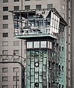
 Langebro Control Tower, seen from southeast
 -
 Langebro Control Tower, seen from east-southeast


See also
[edit]References
[edit]- ^"Da Langebro kun var for soldater".Berlingske(in Danish).Retrieved1 February2017.[permanent dead link]
- ^"Kvægtorvsstationen".evp.dk(in Danish).Retrieved1 February2017.
- ^"Langebro".Selskabet for Københavns Historie. Archived fromthe originalon 2011-07-19.Retrieved2009-11-12.
- ^"Lille Langebro".Realdania By & Byg.Retrieved12 January2022.
- ^"Lille Langebro".RIBA Architecture. 2021.Retrieved10 January2022.
- ^"H.C. Andersen: Langebro".H. C. Andersen Centret.Retrieved2009-11-12.
- ^"Reptilicus, 1961".plaschicke.dk. Archived fromthe originalon 2009-01-03.Retrieved2009-11-12.
- ^"Film 2 Olsenbanden på spanden Die Olsenbande in der Klemme".olsenbande-homepage.de(in German).Retrieved2014-05-29.
- ^"Film 7 Olsen banden på sporet / Die Olsenbande stellt die Weichen".olsenbande-homepage.de(in German).Retrieved5 October2017.
- ^"Reptilicus, 1961".DVM.Retrieved2009-11-12.[permanent dead link]