
Llanrwst
| Llanrwst | |
|---|---|
 Pont Fawr, Llanrwst | |
 Llanrwst Location withinConwy | |
| Area | 5.24 km2(2.02 sq mi) |
| Population | 3,323[1] |
| •Density | 634/km2(1,640/sq mi) |
| OS grid reference | SH800615 |
| Community |
|
| Principal area | |
| Preserved county | |
| Country | Wales |
| Sovereign state | United Kingdom |
| Post town | LLANRWST |
| Postcode district | LL26 |
| Dialling code | 01492 |
| Police | North Wales |
| Fire | North Wales |
| Ambulance | Welsh |
| UK Parliament | |
| Senedd Cymru – Welsh Parliament | |
Llanrwst('church or parish ofSaint Grwst';Welsh pronunciation:[ɬanˈruːst]) is amarket townandcommunityon theA470 roadand theRiver Conwy,inConwy County Borough,Wales,and thehistoric countyofDenbighshire.It developed round thewool tradeand became known also for the making ofharpsand clocks.[3]Today, less than one mile (two kilometres) from the edge ofSnowdonia,[4]its main pursuit istourism.Notable buildings includealmshouses,two 17th-century chapels, and theParish Church of St Grwst,which holds a stone coffin ofLlywelyn the Great.The2011 censusgave it a population of 3,323.
History[edit]
The site of the original church dedicated to St Grwst was Cae Llan in Llanrwst (land now occupied by the Seion Methodist Chapel).[5]The current church ofSt Grwstis on land which was donated in about 1170 by Rhun ap Nefydd Hardd, a member of the royal family of theKingdom of Gwynedd,specifically to build a new church so dedicated.[6]
Llanrwst developed around thewool trade,and for a long time the price of wool for the whole of Britain was set here.[8]The growth of the village in the 13th century was considerably aided by an edict byEdward I of England(who builtConwy Castle) prohibiting any Welshman from trading within 10 miles (16 km) of the town of Conwy. Llanrwst, located some 13 miles (21 km) from that town, was strategically placed to benefit from this.
In 1276,Llywelyn ap Gruffudd,Prince of Wales,seized the town, declaring it theFree Borough of Llanrwstindependent of thediocese of Llanelwy.This the bishop contested, but the borough kept its freedom for the lifetime of Llywelyn and later through efforts byAberconwy Abbey,which ripped down banners relating to the bishopric or toEdward I of England.A century later, after themonasterymoved toMaenan Abbey,[9]the town had its owncoat of armsand flag, the origin of the local motto"Cymru, Lloegr a Llanrwst"(Wales, England and Llanrwst). This motto, a testament to this apparent independence, has now become synonymous with the song of that title by a local band,Y Cyrff.When theLlanrwst Almshouses & Museum Trustclosed in 2011,[10]it returned to the community the 12th-century Llanrwst flag, as an emblem central to the town's belief in its independence.[11]
In 1610Sir John Wynnof Gwydir had the historic LlanrwstAlmshousesbuilt to house poor people of the parish. These closed in 1976, but were restored in 1996 with the aid ofHeritage Lotteryfunding, reopening as a museum of local history and community focal point. It held a collection of over 100 items relating largely to the rural Conwy valley, and a number associated with the renowned Llanrwst Bards of the late 19th century. It closed as a museum in 2011, but reopened in 2013 as the new council chamber.[10][12][13]
Grade I-listedPont Fawr, a narrow, three-arched stone bridge said to have been designed byInigo Jones,was built in 1636 bySir Richard Wynn(son of Sir John Wynn) ofGwydir Castle.[14]It links the town with Gwydir, amanor housedating from 1492, a 15th-centurycourthouseknown asTu Hwnt i'r Bont,and a road from nearbyTrefriw.[15][16][17]North of the village is the site of a house, Plas Madoc, which was the home of Colonel John Higson. A friend ofHenry PochinofBodnant,Higson developed a garden at Plas Madoc which may have had input from, or been influenced byHenry Ernest Milner.The house has been demolished but the garden remains and is listed at Grade II on theCadw/ICOMOS Register of Parks and Gardens of Special Historic Interest in Wales.[18]
In 1947, Llanrwst Town Council allegedly sought in vain for a seat on theUnited Nations Security Councilas an independent state within Wales.[11][19]This is not confirmed in theUnited Nations Security Councilminutes available online.[20]
Llanrwst hosted theNational Eisteddfodin 1951, 1989 and 2019.[21]

Geography[edit]
Llanrwst lies between 10 and 50 metres (33 and 160 ft) above sea level on the eastern bank of the River Conwy. The A470 trunk route between North and South Wales runs through the town, joined by the A548 main road fromRhyl,PrestatynandChester.To the south-west isGwydir Forest.On the hills above isMoel Maeloganwind farm;the power generated by its turbines is fed to the town sub-station.
In 1830 local doctor and naturalist John Williams published a workFaunula Grustensis('Crusty Plants') which described the fauna, geography and pathologies in and around Llanrwst.
-
 Frontispiece of "Faunula Grustensis" by John Williams published in 1830
 -
 Church of St Grwst
 -
 The River Conwy at Llanrwst
 -
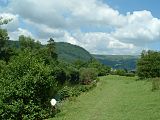
 An elevated view of Llanrwst from Gwydir Forest


Governance[edit]
There are two tiers of local government covering Llanrwst, atcommunity(town) andcounty boroughlevel: Llanrwst Town Council andConwy County Borough Council.
Llanrwst was the name of theelectoral wardtoGwyneddCounty Council between 1973 and 1996, electing one county councillor.[22]
Llanrwst now divides into two such wards,GowerandCrwst,each sending a councillor toConwy County Borough Council.[23]In 2017, Plaid Cymru's Aaron Wynne was elected to the Crwst ward at the age of 20 years, making him Wales's youngest county councillor and Conwy County Borough Council's youngest ever elected member. The town also elects members to Llanrwst Town Council.[24]
Administrative history[edit]
Llanrwst was anancient parishin the historic county ofDenbighshire.[25]When elected parish and district councils were established in 1894 it was given a parish council and included in theLlanrwst Rural District.In 1897 part of the parish was converted into anurban district.[26]Llanrwst Urban District was abolished in 1974 and its area became a community instead. District-level functions passed toAberconwy Borough Council,which was in turn replaced in 1996 by Conwy County Borough Council.[27][28]
Demography[edit]
In the 2011 census the town population was put at 3,323,[1]61 per cent beingWelshspeakers.[29]At one time Llanrwst was the Wales's eighth largest town, with a higher population thanCardiff.[31][32]The change in the town population in the 19th and 20th centuries appears in the chart below.

Transport[edit]
Llanrwst has tworailway stations,LlanrwstandNorth Llanrwst,on theConwy Valley Line,which terminated here before being extended toBetws-y-Coedin 1867 andBlaenau Ffestiniogin 1879. It was originally envisaged that the railway would pass closer to the river, on the site of today's Central Garage. The Victoria Hotel was built opposite the bridge in anticipation of this. Had the line been built on the west bank of the River Conwy, as originally planned, to serve the inland port ofTrefriwacross the river from Llanrwst, it is unlikely that Llanrwst would have gained its present status.
-
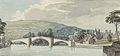 18th century water colour of Llanrwst Bridge
 -
 Plan of bridge, 1753
 -
 Engraving, 1790
 -
 Early 19th century
 -
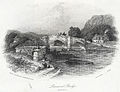 Engraving, 1842


Education[edit]
Ysgol Dyffryn Conwy,previously Llanrwst Grammar School, is a bilingualsecondary schoolwith about 790 pupils. According to the latest inspection report byEstyn,it has aGCSEpass rate of 71 per cent (based on five GCSEs, grades A–C), putting the school in equal 24th place, just outside the top 10 per cent of secondary schools inWales.It is also the second best-performing secondary school inConwy,behindEirias High SchoolinColwyn Bay.
There is a Christian-based youth club in Seion Chapel called Clwb Cyfeillion.
Sport[edit]
Llanrwst hostsLlanrwst United FC,with two seniorteams.The first plays in the Welsh Alliance League and the reserves in Clwyd League Division 2. The club has a junior section of eight teams, playing in the Aberconwy and Colwyn League.Llanrwst Cricket Clubplays in theNorth Wales Premier Cricket League.Since 2012, there has been an annualhalf marathonround the town.[33]
Notable people[edit]
In birth order:
- Evan Owen Allen(1805–1852), Welsh-language journalist and poet, born at Pant-y-llin, near Llanrwst
- Peter Thomas, Baron Thomas of Gwydir(1920-2008), Welsh politician, born in Llanrwst, a former Secretary of State for Wales
- Mark Roberts(born 1967) ofCatatoniaand its predecessorY Cyrff,known for the songCymru, Lloegr a Llanrwst
- Kai Owen(born 1975), actor notable asRhys WilliamsinTorchwood
- Glyn Wise(born 1988), runner-up as aBig Brother 7 (UK)contestant on television in 2006, attended Ysgol Dyffryn Conwy.
- Alex Frew (born 1988), graphic designer, created the Wales brand and Transport for Wales brand identities.
- Erin Mai(born 2005 or 2006), Wales's representative at the2019 edition of the Junior Eurovision Song Contestwith "Calon yn Curo (Heart Beating)"after victory at theS4CshowChwilio am Seren
See also[edit]
References[edit]
- ^ab"Area: Llanrwst (Parish), Key Figures for 2011 Census: Key Statistics".Neighbourhood Statistics.Office for National Statistics.Retrieved15 May2014.
- ^"Cyngor Llanrwst".Retrieved3 May2023.
- ^"snowdoniaantiques.co.uk - Snowdonia Antiques. North Wales Fine Antique Furniture and Clock Specialists".snowdoniaantiques.co.uk.
- ^Snowdonia National Park Authority."Location Map".Archived fromthe originalon 23 October 2014.
- ^"History of Llanrwst: Saint Grwst the Confessor".Retrieved18 April2015.
- ^"History of Llanrwst: Foundation of the Modern Church".Retrieved3 May2023.
- ^Lewis, Samuel (1840).A Topographical Dictionary of Wales Vol 1.London: S Lewis.ISBN9780598739971.
- ^"Llanrwst is the principal mart for this article, and is attended by the English buyers: the price obtained for the wool at this fair is usually the standard for the year."[7]
- ^"BBC – Gogledd Orllewin – hanes".Retrieved3 May2023.
- ^ab"Llanrwst Almshouse Museum rent rise blamed for closure".BBC News.27 October 2011.Retrieved18 April2015.
- ^abTalk of the townBBC News,28 April 2006.
- ^"Celebrations as town council re-open Llanrwst Almshouses Museum".Daily Post. 28 February 2013.
- ^"Llanrwst Almshouses re-opens and is taken on by village council".Daily Post. 11 July 2013.Retrieved18 April2015.
- ^Cadw."Pont Fawr (Grade I) (16951)".National Historic Assets of Wales.Retrieved14 July2019.
- ^"Tu Hwnt Ir Bont Tearooms - Llanrwst Conwy North Wales".www.tuhwntirbont.co.uk.
- ^"Tu Hwnt ir Bont in Wales".Wales Directory.
- ^"Llanrwst"(PDF).Conservation Area Appraisal – Conwy County Borough Council.Conwy County Borough Council. Archived fromthe original(PDF)on 18 April 2015.
- ^Cadw."Plas Madoc (PGW(Gd)2(CON))".National Historic Assets of Wales.Retrieved6 February2023.
- ^Breverton, Terry(2012).Owain Glyndwr: The Story of the Last Prince of Wales.Amberley Publishing Limited.ISBN978-1445608761.
- ^"Chapter II. Agenda"(PDF).un.org.Retrieved3 May2023.
- ^"National Eisteddfod".National Eisteddfod.Retrieved15 March2018.
- ^"Gwynedd Council Election Results 1995-2012"(PDF).The Elections Centre (Plymouth University).Retrieved23 April2019.
- ^"Ward Map".Llanrwst Town Council.2021.Retrieved28 February2022.
- ^"Llanrwst Town Council, Llanrwst.net. Retrieved 23 March 2018".Archived fromthe originalon 22 February 2014.Retrieved23 March2018.
- ^"Llanrwst Ancient Parish / Civil Parish".A Vision of Britain through Time.GB Historical GIS / University of Portsmouth.Retrieved18 January2024.
- ^Annual Report of the Local Government Board.1898. p. 287.Retrieved18 January2024.
- ^Local Government Act 1972
- ^Local Government (Wales) Act 1994
- ^"Archived copy"(PDF).Archived fromthe original(PDF)on 5 March 2014.Retrieved5 March2014.
{{cite web}}:CS1 maint: archived copy as title (link) - ^"Cardiff Glamorgan".Vision of Britain.
- ^"In 1801 the pop. [of Cardiff] was only 1018; in 1841 it was 10,077..."[30]
- ^"Llanrwst CP/AP".Vision of Britain.
- ^"Snowdonia Half Marathon – Run Wales".www.runwales.com.
External links[edit]
- A Vision of Britain Through Time
- British Listed Buildings
- Clwyd Churches
- Genuki
- Geograph
- Office for National Statistics

| Towns | |
|---|---|
| Other settlements | |
| Rivers & streams | |
| Lakes | |
| Waterfalls | |
| Hills & mountains | |
| Castles & forts | |
| Bridges | |
| Other features | |
| Transport | |
| Railway stations | |
| International | |
|---|---|
| National | |
| Geographic | |