
Longridge Fell
This articleneeds additional citations forverification.(October 2023) |
| Longridge Fell | |
|---|---|
 The east end of Longridge Fell, withPendle Hillbehind, to the left | |
| Highest point | |
| Elevation | 1,148 ft (350 m) |
| Prominence | 794 ft (242 m) |
| Parent peak | Ward's Stone |
| Listing | Marilyn |
| Coordinates | 53°51′51″N2°31′09″W/ 53.8643°N 2.5193°W |
| Geography | |
 Longridge Fell Location in Lancashire  Longridge Fell Location in Ribble Valley Borough  Longridge Fell Location in the Forest of Bowland | |
| Location | Lancashire,England |
| OS grid | SD658410 |
Longridge Fellis the most southerlyfellin England, near thetownofLongridge,Lancashire.[1]It lies at the southern end of theForest of BowlandArea of Outstanding Natural Beauty.As its name suggests, it takes the form of a long ridge which rises in a north-easterly direction from within the town of Longridge to its summit 4.5 miles distant. As the ridge curves towards the east, it comes to a sudden end and drops into theHodder Valley.The fell is an example of acuesta;the ridge has a sharp drop orescarpmenton its northern side, and a gentler, more varying slope on its southern side.[2]These features make it a popular takeoff for hang-gliders and paragliders on the relatively infrequent occurrences of a northerly wind.
From the fell's 1,148-ft (350-m) summit, views are afforded ofPrestonto the south-west; theFylde Coastto the west; the Vale of Chipping and the fells of theForest of Bowlandto the north and west (includingParlick,Fair Snape FellandBeacon Fell); theYorkshire Dalesto the north-east (including, most notably,Pen-y-ghent);Clitheroe,Pendle HillandWhalley,to the east and south-east; andWinter Hilland theWest Pennine Moorsand theBAE Systemsfactory atSamlesbury Aerodrome.On clear days, theLake Districtand sometimes theIsle of Mancan be seen to the north-west, and theSnowdoniamountain range to the south-west.
TheRiver Hodderand itstributary,theRiver Loud,flow eastward along the north side of the fell, before turning south at the end of the fell to join theRiver Ribble,which runs westward along the south of the fell. Cowley Brook, a tributary ofStydd Brook,begins its course near the fell. The village ofHurst Greenand the adjoiningStonyhurst Collegelie on the south side of the fell.
Longridge town lies at the south-west end of the fell. There were once extensive stone quarries at Tootle Heights, now mostly built on apart from a deep rocky water-filled remnant off the Tan Yard bridlepath, and the reservoirs. The Dilworth UpperReservoirbetween the roads where Forty Acre Lane branches off Higher Road, leading from Longridge up the fell. Forty Acre Lane leads towards Jeffrey Hill, the name for a small part of the western section of the fell, viaLongridge Golf Club,whose clubhouse doubles as the home of the Preston Wheelers Cycling Club. Below Tootle Heights are the Spade Mill Reservoirs.
Gallery
[edit]-
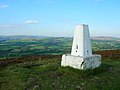 Thetrig pointat the summit of Longridge Fell, looking north
 -
 A view from the northern section of Longridge golf course across the Vale of Chipping to Parlick and Fair Snape Fell
 -
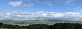
 View over the Vale of Chipping
 -
 View north over the Loud Valley
 -
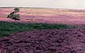 The western slopes of the fell, around Jeffrey Hill


Notes
[edit]- ^(14 December 2011),"Longridge’s Mr Heritage",Longridge News,accessed 14 November 2014
- ^Freemanet al,p.12
References
[edit]- Freeman, T. W., Rodgers, H. B., and Kinvig, R. H., (1966),Lancashire, Cheshire and the Isle of Man,Thomas Nelson and Sons Ltd, London
External links
[edit]Marilynsof Northern England | ||
|---|---|---|
| 1. Northumberland |  | |
| 2. Northern Lakeland | ||
| 3. Western Lakeland | ||
| 4. Central and Southern Lakeland | ||
| 5. Eastern Lakeland | ||
| 6. North Pennines and Durham | ||
| 7. Northern Yorkshire Dales | ||
| 8. Southern Yorkshire Dales | ||
| 9. North York Moors to the Humber | ||
| 10. Forest of Bowland | ||