
Lourenzá
Lourenzá | |
|---|---|
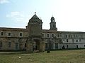
 Town hall and former monastery of San Salvador de Lourenzá. | |
 Flag  Coat of arms | |
 Location of Lourenzá | |
| Country | |
| Autonomous community | |
| Province | Lugo |
| Comarca | A Mariña Central |
| Government | |
| •Alcalde | Rocío López García (PSdeG-PSOE) |
| Area | |
| • Total | 62.53 km2(24.14 sq mi) |
| Population (2023)[3] | |
| • Total | 2,115 |
| • Density | 34/km2(88/sq mi) |
| Demonym(s) | Valego, laurentiniano |
| Time zone | UTC+1(CET) |
| • Summer (DST) | UTC+2(CEST) |
| Postal code | 27760 |
| Website | Official website |
Lourenzá(Galician pronunciation:[lowɾenˈθa]) is a municipality in the province ofLugo,in the autonomous community ofGaliciain northwesternSpain.
It is the site of the monastery of San Salvador.[4]The façade of its church is said to have been a prototype for that ofSantiago de Compostela Cathedral.
Gallery
[edit]-
 Dovecote
 -
 Park of Vilanova de Lourenzá.


References
[edit]- ^"Rocío López García, del PSOE, recibe por segunda vez el bastón de mando de Lourenzá".La Voz de Galicia(in Spanish). 15 June 2019.Retrieved28 July2024.
- ^"Entidades Locales".ssweb.seap.minhap.es.Retrieved28 July2024.
- ^"Instituto Nacional de Estadística. (Spanish Statistical Institute)".www.ine.es.Retrieved28 July2024.
- ^"MONASTERIO SAN SALVADOR DE LOURENZÁ EN LOURENZÁ LUGO".Turgalicia(in Spanish). 2 March 2022.Retrieved28 July2024.
43°26′00″N7°13′00″W/ 43.4333°N 7.2167°W
This article about a location in the autonomous community of Galicia, Spain is astub.You can help Wikipedia byexpanding it. |