
Makassar Strait
| Makassar Strait | |
|---|---|
| Selat Makassar(Indonesian) | |
 Makassar Strait Map | |
 Makassar Strait Location of Makassar Strait  Makassar Strait Makassar Strait (Indonesia)  Makassar Strait Makassar Strait (Southeast Asia) | |
| Location | Indonesia |
| Coordinates | 0°0′0″N118°30′00″E/ 0.00000°N 118.50000°E |
| Type | strait |
| Basincountries | Indonesia |
| Islands | +100 |
| Settlements | Balikpapan,Bontang(Kalimantan) Makassar,Palu,Parepare(Sulawesi) |
| References | Macassar Strait: OS (Oceans)National Geospatial-Intelligence Agency, Bethesda, MD, USA |
Makassar Strait(Indonesian:Selat Makassar) is astraitbetween the islands ofBorneoandSulawesiinIndonesia.To the north it joins theCelebes Sea,while to the south it meets theJava Sea.To the northeast, it forms theSangkulirang Baysouth of theMangkalihat Peninsula.The strait is an important regional shipping route inSoutheast Asia.
TheMahakam RiverandKarangan Riverof Borneo empty into the strait.
Ports along the strait includeBalikpapanandBontangin Borneo, andMakassar,Palu,andPareparein Sulawesi. The city ofSamarindais 48 km (30 mi) from the strait, along the Mahakam.
Extent
[edit]TheInternational Hydrographic Organization(IHO) defines the Makassar Strait as being one of the waters of theEast Indian Archipelago.The IHO defines its limits as follows:[1]
The channel between the East coast ofBorneoand the West coast of Celebes [Sulawesi], is bounded:
On the North.By a line joiningTanjong Mangkalihat,Borneo (1°02′N118°57′E/ 1.033°N 118.950°E) and Stroomen Kaap (Cape Binar), Celebes (1°20′N120°52′E/ 1.333°N 120.867°E).
On the South.By a line from the Southwestern extreme of Celebes (5°37′S119°27′E/ 5.617°S 119.450°E), through the Southern point ofTana Keke,to the Southern extreme ofLaoet(4°06′S116°06′E/ 4.100°S 116.100°E) thence up the West coast of that island to Tanjong Kiwi and thence across to Tanjong Petang, Borneo (3°37′S115°57′E/ 3.617°S 115.950°E) at the Southern end of Laoet Strait.
Geology
[edit]The Makassar Strait and North Makassar Basin is the result of back-arc extension due to the subduction of a small tectonic slab to the east.[2]Rifting began in the Eocene, with high sedimentation rates filling the extension basin throughout the Eocene through Miocene. These Miocene basin sediments hold very large amounts of oil and natural gas deposits, especially in the hydrocarbon richKutei Basin.
The arrival of theBenggai Sulamicroplate has rotated the Island of Sulawesi in a counter-clockwise direction, allowing opening of the southern Makassar Basin with accommodation by the Adang/Paternoster Fault.
Gallery
[edit]-
 Beras Basah Island in Makassar Strait, administrative part ofBontang.
 -
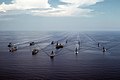 USSMidway(CV-41)and other warships in Makassar Strait, 28 September 1985.
 -
 Offshore oil rig in Makassar Strait, 2005.
 -
 Aur island, administrative part of South Kalimantan.
 -
![KM Arista ship sunk in Makassar Strait, 10 June 2015.[3]](https://upload.wikimedia.org/wikipedia/commons/thumb/4/46/65_Indonesians_saved_from_tragedy_by_U.S._Marines%2C_Sailors_150610-M-ST621-142.jpg/120px-65_Indonesians_saved_from_tragedy_by_U.S._Marines%2C_Sailors_150610-M-ST621-142.jpg) KM Arista ship sunk in Makassar Strait, 10 June 2015.[3]
KM Arista ship sunk in Makassar Strait, 10 June 2015.[3]


![KM Arista ship sunk in Makassar Strait, 10 June 2015.[3]](/translate/en.wikipedia.org?u=https%3A%2F%2Fen.wikipedia.org%2Fwiki%2FFile%3A65_Indonesians_saved_from_tragedy_by_U.S._Marines%2C_Sailors_150610-M-ST621-142.jpg&t=hv)
See also
[edit]- Battle of Makassar Strait
- USS Makassar Strait
- Strait of Malacca
- Sunda Strait
- Lombok Strait
- Wallace Line
- Sadang River
References
[edit]- ^"Limits of Oceans and Seas, 3rd edition"(PDF).International Hydrographic Organization. 1953. Archived fromthe original(PDF)on 8 October 2011.Retrieved28 December2020.
- ^Guntoro, Agus (February 1999)."The formation of the Makassar Strait and the separation between SE Kalimantan and SW Sulawesi".Journal of Asian Earth Sciences.17(1–2): 79–98.doi:10.1016/S0743-9547(98)00037-3.
- ^"Navy vessel rescues 65 people in Makassar Strait | IHS Fairplay".fairplay.ihs.com.Retrieved2018-11-30.
ThisIndonesialocation article is astub.You can help Wikipedia byexpanding it. |