
Mals
Mals | |
|---|---|
| Gemeinde Mals Comune di Malles Venosta | |
 | |
 Coat of arms | |
Location of Mals  | |
 Mals Location of Mals in Italy  Mals Mals (Trentino-Alto Adige/Südtirol) | |
| Coordinates:46°42′N10°33′E/ 46.700°N 10.550°E | |
| Country | Italy |
| Region | Trentino-Alto Adige/Südtirol |
| Province | South Tyrol(BZ) |
| Frazioni | Burgeis (Burgusio), Laatsch (Laudes), Matsch (Mazia), Planeil (Planol), Plawenn (Piavenna), Schleis (Clusio), Schlinig (Slingia), Tartsch (Tarces), Ulten-Alsack (Alsago-Ultimo) |
| Government | |
| • Mayor | Josef Thurner |
| Area | |
| • Total | 246.7 km2(95.3 sq mi) |
| Elevation | 1,051 m (3,448 ft) |
| Population (Nov. 2010)[2] | |
| • Total | 5,092 |
| • Density | 21/km2(53/sq mi) |
| Demonym(s) | German: Malser Italian: mallesi |
| Time zone | UTC+1(CET) |
| • Summer (DST) | UTC+2(CEST) |
| Postal code | 39024 |
| Dialing code | 0473 |
| Website | Official website |
Mals(German pronunciation:[mals];Italian:Malles Venosta[ˈmallezveˈnɔsta]) is acomune(municipality) and a village inSouth Tyrolin northernItaly,located about 70 kilometres (43 mi) northwest ofBolzano,on the border withSwitzerlandandAustria.
History[edit]
Coat-of-arms[edit]
The emblem isparty per fess:the upper ofgulesafessargent,at the bottomorthree gules circles arranged in a triangle upside-down. It is the combination of coats of arms of theHouse of AustriaandMedici.The emblem was adopted in 1928.[3]
Geography[edit]
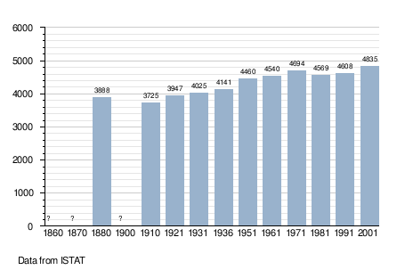
As of 30 November 2010, it had a population of 5,092 and an area of 246.7 square kilometres (95.3 sq mi).[4]TheZerzer Tal,aside valleyof theVinschgau,is in Mals.
Mals borders the following municipalities:Graun im Vinschgau,Glurns,Laas,Scuol(Switzerland),Schnals,Sent(Switzerland),Schlanders,Schluderns,Sölden(Austria), andTaufers im Münstertal.
Frazioni[edit]
The municipality of Mals contains thefrazioni(subdivisions, mainly villages and hamlets): Burgeis (Burgusio), Laatsch (Laudes), Matsch (Mazia), Planeil (Planol), Plawenn (Piavenna), Schleis (Clusio),Schlinig(Slingia), Tartsch (Tarces), and Ulten-Alsack (Alsago-Ultimo).
Climate and Temperature[edit]
| Climate data for Mals ITA, 2009–2018 normals | |||||||||||||
|---|---|---|---|---|---|---|---|---|---|---|---|---|---|
| Month | Jan | Feb | Mar | Apr | May | Jun | Jul | Aug | Sep | Oct | Nov | Dec | Year |
| Record high °C (°F) | 3 (37) |
3 (37) |
7 (45) |
13 (55) |
19 (66) |
22 (72) |
24 (75) |
24 (75) |
20 (68) |
17 (63) |
12 (54) |
4 (39) |
24 (75) |
| Mean maximum °C (°F) | 0.8 (33.4) |
1.2 (34.2) |
3.0 (37.4) |
7.6 (45.7) |
14.6 (58.3) |
20.4 (68.7) |
21.2 (70.2) |
21.8 (71.2) |
16.9 (62.4) |
12.6 (54.7) |
5.9 (42.6) |
1.9 (35.4) |
22.6 (72.7) |
| Mean daily maximum °C (°F) | −4.0 (24.8) |
−3.9 (25.0) |
−0.6 (30.9) |
2.6 (36.7) |
7.3 (45.1) |
12.9 (55.2) |
16.0 (60.8) |
15.9 (60.6) |
11.7 (53.1) |
6.2 (43.2) |
0.4 (32.7) |
−3.3 (26.1) |
5.1 (41.2) |
| Daily mean °C (°F) | −8.7 (16.3) |
−8.8 (16.2) |
−5.4 (22.3) |
−1.8 (28.8) |
2.8 (37.0) |
7.9 (46.2) |
10.5 (50.9) |
10.5 (50.9) |
6.8 (44.2) |
2.0 (35.6) |
−3.2 (26.2) |
−7.3 (18.9) |
0.4 (32.7) |
| Mean daily minimum °C (°F) | −13.3 (8.1) |
−13.7 (7.3) |
−10.2 (13.6) |
−6.1 (21.0) |
−1.8 (28.8) |
2.8 (37.0) |
4.9 (40.8) |
5.1 (41.2) |
1.9 (35.4) |
−2.3 (27.9) |
−6.7 (19.9) |
−11.2 (11.8) |
−4.2 (24.4) |
| Mean minimum °C (°F) | −24.4 (−11.9) |
−25.3 (−13.5) |
−20.6 (−5.1) |
−15.8 (3.6) |
−10.1 (13.8) |
−4.1 (24.6) |
0.0 (32.0) |
0.0 (32.0) |
−2.8 (27.0) |
−12.0 (10.4) |
−17.1 (1.2) |
−20.9 (−5.6) |
−27.5 (−17.5) |
| Record low °C (°F) | −32.0 (−25.6) |
−29.0 (−20.2) |
−27.0 (−16.6) |
−22.0 (−7.6) |
−18.0 (−0.4) |
−11.0 (12.2) |
−1.0 (30.2) |
−2.0 (28.4) |
−6.0 (21.2) |
−18.0 (−0.4) |
−34 (−29) |
−26 (−15) |
−34 (−29) |
| Average rainfall mm (inches) | 16.37 (0.64) |
18.50 (0.73) |
18.43 (0.73) |
25.90 (1.02) |
30.85 (1.21) |
32.41 (1.28) |
29.00 (1.14) |
32.83 (1.29) |
35.02 (1.38) |
53.43 (2.10) |
31.29 (1.23) |
21.66 (0.85) |
345.67 (13.61) |
| Average snowfall cm (inches) | 13.5 (5.3) |
15.5 (6.1) |
14.5 (5.7) |
20.1 (7.9) |
19.8 (7.8) |
8.3 (3.3) |
1.3 (0.5) |
3.2 (1.3) |
14.0 (5.5) |
31.2 (12.3) |
23.4 (9.2) |
16.4 (6.5) |
181.3 (71.4) |
| Averagerelative humidity(%) | 90.9 | 92.7 | 92.6 | 92.4 | 89.6 | 81.7 | 77.8 | 79.8 | 81.2 | 83.4 | 89.0 | 85.9 | 86.4 |
| Source: World Weather Online[5] | |||||||||||||
Mals has a cool, wet climate. Frost is common from October to May and is even recorded in the summer, although temperatures below −1C are rare from June to September. Most winter days fail to rise above freezing. Summer is generally mild, but most summers see temperatures rise above 20C on several days.
Transportation[edit]
The commune is the northern terminus of the train fromMeran.The trip from Merano takes approximately 1 hour 15 minutes. Trains depart hourly. There is also local bus service between Mals and Schlanders.[6]
Notable people[edit]
- Johann Rufinatscha(1812–1893), an Austrian composer, theorist and music teacher
- Walter Caldonazzi(1916–1945), an important resistance fighter against Nazi Germany[7]
- Karl Plattner(1919–1986), painter.
- Gabriel Grüner(1963–1999), journalist for Stern magazine, shot by Yugoslav soldiers
Society[edit]
Linguistic distribution[edit]
According to the 2011 census, 96.92% of the population speakGerman,3.00%Italianand 0.08%Ladinas first language.[8]
Demographic evolution[edit]
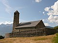
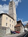
Gallery[edit]
-
 St. Benedict's Church in Mals
 -
 St. Veit am Bichlin Tartsch
 -
 Tower of the old St. John's Church
 -
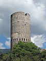 The towerFröhlichsturmin Mals


References[edit]
- ^"Superficie di Comuni Province e Regioni italiane al 9 ottobre 2011".Italian National Institute of Statistics.Retrieved16 March2019.
- ^"Popolazione Residente al 1° Gennaio 2018".Italian National Institute of Statistics.Retrieved16 March2019.
- ^Heraldry of the World: Mals
- ^All demographics and other statistics: Italian statistical instituteIstat.
- ^"Mals, Italy Weather Averages".World Weather Online.RetrievedMarch 4,2019.
- ^"SII Timetables".SAD Trasporto Locale S.p.A.Retrieved26 December2016.
- ^Caldonazzi, Walter
- ^"Volkszählung 2011/Censimento della popolazione 2011".astat info(38). Provincial Statistics Institute of the Autonomous Province of South Tyrol: 6–7. June 2012.Retrieved2012-06-14.
External links[edit]
![]() Media related toMalsat Wikimedia Commons
Media related toMalsat Wikimedia Commons
- Municipality of Mals Homepage(in German and Italian)
- General information about Mals, Tourism and Shopping(English)

| International | |
|---|---|
| National | |
| Geographic | |