Mangshi
Mangshi
Mang thị | |
|---|---|
| Other transcription(s) | |
| •Pinyin | Mángshì |
| •Tai Nuea | ᥝᥥᥒᥰ ᥛᥫᥒᥰ ᥑᥩᥢᥴ |
| •Jingpho | Mangshi Myu |
| •Burmese | မန်စီ |
| •Thai | เมืองข้อน |
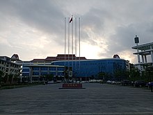
Clockwise: Urban skyline, Menghuan Pagoda, Mangshi Little Hall, Mangshi Square,Puti Temple | |
| Etymology: Evolved form the ethnic name "MangThi"(Mangshi) | |
| Nickname: city of dawn | |
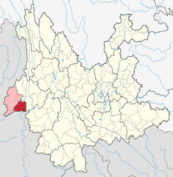 Location of Mangshi City in Dehong Prefecture within Yunnan province | |
| Coordinates (Mangshi government):24°26′01″N98°35′17″E/ 24.4337°N 98.5881°E | |
| Country | China |
| Province | Yunnan |
| Autonomous Prefecture | Dehong |
| Founded | 1996 |
| Municipal seat | Menghuan Subdistrict |
| Area [1]: 536 | |
| • Total | 2,900.91 km2(1,120.05 sq mi) |
| Elevation | 933 m (3,061 ft) |
| Population (2020 census)[2] | |
| • Total | 439,931 |
| • Density | 150/km2(390/sq mi) |
| Time zone | UTC+8(China Standard) |
| Postal code | 678400 |
| Phone code | (0)692 |
| Website | www |
Mangshi(Chinese:Mang thị;Wade–Giles:Mangshih;Tai Nüa:ᥝᥥᥒᥰ ᥛᥫᥒᥰ ᥑᥩᥢᥴ;Jingpho:Mangshi Myu), former nameLuxi(Lộ tây),[3]is acounty-level cityand the seat ofDehong Dai and Jingpo Autonomous Prefecture,westernYunnanprovince, China. Mangshi has an area of 2,900.91 km2(1,120.05 sq mi), with an urban area of 18.66 km2(7.20 sq mi).[4]Han Chinese,Dai people(Tai Nuea branch) andJingpo people(Zaiwa branch) are the major ethnic groups. Luxi County was founded in 1949, and became a county-level city in 1996.
Etymology
[edit]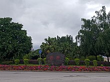
The name "Mangshi" first appeared in 1443, when the Tai NueatusiMangshiYuyi Zhangguansi(Mang thị ngự di trường quan tư) was established. In the history, an ethnicity named Mangshi (MangThi) lived in this area. The name of "MangThị"evolved from"Mang thi"(thepinyinare same).Luxi(LộTây) is the former name of Mangshi, meaning "west ofLu[Salween] River ".[5]: 460
InTai Nuea language,the city name isMuangKhon[6]: 18 (ᥛᥫᥒᥰ ᥑᥩᥢᥴ), written in Chinese is "MãnhHoán",meaning" city of dawn ".[5]: 460
In 2008, 4,751 people participated in a public opinion survey in favour of restoring the historical name (Mangshi), with 96.96% supporting a name change to Mangshi.[3]In 2010, the name was formally changed. "Mangshi" is theproper nameof the city, however, the character "Thị"(shì) itself means "city".[7]The full name in Chinese language is "Mang thị"(Mangshi), the official English translation in theYearbook of Dehongis "Mangshi City".[8]
History
[edit]


Historically, Mangshi was divided among threetusiterritories. MangshiLu(Mang thi lộ), established byYuan dynastyin 1276, was the first time the region was integrated into the administrative system of a Chinese dynasty. Mangshi Lu was part of JinchiXuanfusi(Kim xỉ đẳng xử tuyên phủ tư), Yunnan Province. In 1277, the area was affected by thefirst Mongol invasion of Burma.Ming dynastyrepealed Mangshi Lu and set MangshiFu(Mang thi phủ) in 1382. Because Mangshi chief Dao Fangge (Đao phóng cách) helped the Ming dynasty army in theLuchuan–Pingmian campaigns,Ming dynasty made him the MangshiTusi(native chieftain), and founded the agency MangshiYuyi Zhangguansi(Mang thị ngự di trường quan tư) in 1443. In 1584, Ming dynasty created another tusi,ZhefangFuxuanfusi(Già phóng phó tuyên phủ tư) inZhefangarea, formerly part ofLongchuanXuanfusi(Lũng xuyên tuyên phủ tư). In 1640, Mangshi YuyiZhangguansiupgraded to MangshiAnfusi(Mang thị an phủ tư). In 1899,Qing dynastyset the 3rd tusi,MengbanTuqianzong(Mãnh bản thổ thiên tổng) in modern Mangshi Area.[10]: 9, 20–21
InRepublic of China period,the Yunnan government appointed two "suppression commissars" (Đạn áp ủy viên) to Mangban (Mang bản) and Zhemao (Già mão) within the Mangshi area in 1913. Mangban suppression commissar administered MangshiAnfusiand MengbanTuqianzongterritories, and Zhemao suppression commissar administered ZhefangXuanfusiandMengmaoAnfusi(Mãnh mão an phủ tư,inRuili) territories. The two suppression commissars were replaced by an administrative commissar (Hành chính ủy viên) in 1915, and a district named Mangzheban Administrative District (Mang già bản hành chính khu) was established. At the same time, MengmaoAnfusiwas separated from the district, thus forming the boundaries of modern Mangshi. As a transition before formally establishing a county, Yunnan government set aShezhiju(Thiết trị cục,similar to a governing council) in Mangshi area named MangzhebanShezhiju(Mang già bản thiết trị cục) replacing Mangzheban District in 1929. The Administrative Bureau is a quasi-county level administrative division.Menggais the seat of the bureau. It changed the name to LuxiShezhiju(Lộ tây thiết trị cục) in 1934.Imperial Japanese Armyoccupied Luxi at 4May 1942 and retreated at 11 December 1944 whenCounterattack of Western Yunnanstarted. In 1949, Luxi Administrative Bureau finally became Luxi County (Lộ tây huyện), with the seat of county government at the town of Mangshi, and the firstcounty magistratewas the acting TusiFang Kesheng(Phương khắc thắng). The Tusi system and the central bureaucracy still coexisted.[10]: 10–11, 21–22
Fang Kesheng refused to joinPeople's Republic of China,preferring to remain neutral. Eventually thePeople's Liberation Armyadvanced into Luxi in April 1950, and Fang Kesheng fled toTaiwan.His brother Fang Keguang succeeded be the acting tusi, and cooperated with theChinese Communist Party.The three tusi were killed during theland reformmovement in 1955.[9]: 160 Luxi County became Luxi City (county-level city) in 1996, and changed the name to Mangshi City in 2010.[11]: 2547
Geography
[edit]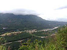
Mangshi has an area of 2,900.91 km2(1,120.05 sq mi). There are two main plains in Mangshi named Mangshi Ba (Mang thị bá) and Zhefang Ba (Già phóng bá). The city of Mangshi is situated at the east of Mangshi Ba.Mountainsare the primarylandformsof Mangshi, making up approximately 84.48% of the territory. Mount Qingkou (Tinh khẩu sơn) is the city's highest point, with an altitude of 2,889.1 meters. Manxin River's (Mạn tân hà) estuary (atSalween River) is the lowest point, with an altitude of 528 metres inZhongshan Township.[10]: 52–53 The mountains are branches of westernGaoligong Mountains.[12]: 40
Mangshi Riveris the "mother river" of Mangshi,[13]and has a drainage basin of 1,881 km2(726 sq mi),[14]: 90–91 about 61.3% of area of Mangshi.Longchuan River(Long xuyên giang) is the border river between Mangshi andLianghe CountyandLongchuan Countyon the north and west.Salween Riveron the southeast tip of Mangshi marks the international border between Mangshi andMyanmar'sShan State.[10]: 59 [5]: 185
Climate
[edit]| Climate data for Mangshi, elevation 914 m (2,999 ft), (1991–2020 normals, extremes 1981–present) | |||||||||||||
|---|---|---|---|---|---|---|---|---|---|---|---|---|---|
| Month | Jan | Feb | Mar | Apr | May | Jun | Jul | Aug | Sep | Oct | Nov | Dec | Year |
| Record high °C (°F) | 27.0 (80.6) |
31.0 (87.8) |
33.4 (92.1) |
35.2 (95.4) |
35.6 (96.1) |
34.9 (94.8) |
34.4 (93.9) |
35.3 (95.5) |
35.7 (96.3) |
33.4 (92.1) |
29.7 (85.5) |
27.4 (81.3) |
35.7 (96.3) |
| Mean daily maximum °C (°F) | 22.2 (72.0) |
24.4 (75.9) |
27.7 (81.9) |
29.7 (85.5) |
29.8 (85.6) |
29.0 (84.2) |
28.3 (82.9) |
29.2 (84.6) |
29.5 (85.1) |
28.0 (82.4) |
25.5 (77.9) |
22.8 (73.0) |
27.2 (80.9) |
| Daily mean °C (°F) | 13.1 (55.6) |
15.1 (59.2) |
18.4 (65.1) |
21.5 (70.7) |
23.6 (74.5) |
24.4 (75.9) |
24.1 (75.4) |
24.5 (76.1) |
24.0 (75.2) |
21.9 (71.4) |
17.8 (64.0) |
14.2 (57.6) |
20.2 (68.4) |
| Mean daily minimum °C (°F) | 6.9 (44.4) |
8.3 (46.9) |
11.4 (52.5) |
15.2 (59.4) |
19.2 (66.6) |
21.6 (70.9) |
21.8 (71.2) |
21.8 (71.2) |
20.9 (69.6) |
18.3 (64.9) |
13.0 (55.4) |
8.9 (48.0) |
15.6 (60.1) |
| Record low °C (°F) | −0.2 (31.6) |
1.5 (34.7) |
3.6 (38.5) |
7.5 (45.5) |
13.2 (55.8) |
16.8 (62.2) |
15.9 (60.6) |
17.6 (63.7) |
14.5 (58.1) |
9.3 (48.7) |
5.5 (41.9) |
1.0 (33.8) |
−0.2 (31.6) |
| Averageprecipitationmm (inches) | 19.9 (0.78) |
19.6 (0.77) |
26.5 (1.04) |
65.4 (2.57) |
147.2 (5.80) |
267.2 (10.52) |
371.9 (14.64) |
339.0 (13.35) |
170.3 (6.70) |
131.6 (5.18) |
38.3 (1.51) |
9.7 (0.38) |
1,606.6 (63.24) |
| Average precipitation days(≥ 0.1 mm) | 3.2 | 4.0 | 5.8 | 10.6 | 16.2 | 23.3 | 27.8 | 25.1 | 19.0 | 13.4 | 5.5 | 2.6 | 156.5 |
| Averagerelative humidity(%) | 76 | 70 | 64 | 66 | 73 | 83 | 87 | 85 | 83 | 81 | 79 | 79 | 77 |
| Mean monthlysunshine hours | 227.9 | 217.8 | 228.8 | 211.8 | 190.3 | 111.8 | 79.4 | 111.9 | 140.1 | 169.3 | 209.9 | 220.1 | 2,119.1 |
| Percentpossible sunshine | 68 | 68 | 61 | 55 | 46 | 27 | 19 | 28 | 38 | 48 | 64 | 67 | 49 |
| Source:China Meteorological Administration[15][16] | |||||||||||||
Administrative divisions
[edit]Mangshi currently comprises 12 administrativetownship-level subdivisionsincluding onesubdistrict,fivetownsand sixtownships.[17]
| Name | Name in Chinese |
Code[18] | Founded [5]: 459–495 |
Area (km2) [11]: 2552–2572 |
Population 2010 Census[19] |
Density |
|---|---|---|---|---|---|---|
| Menghuan Subdistrict | Mãnh hoán nhai đạo | 533103001 | 2008 | 23.15 | 99,970 | 4318.36 |
| Mangshi Town | Mang thị trấn | 533103101 | 1936 | 349.5 | 46,353 | 132.63 |
| Zhefang Town | Già phóng trấn | 533103102 | 1936 | 422 | 51,477 | 121.98 |
| Mengga Town | Mãnh kiết trấn | 533103103 | 1936 | 389 | 24,344 | 62.58 |
| Manghai Town | Mang hải trấn | 533103104 | 1988 | 105 | 5,641 | 53.72 |
| Fengping Town | Phong bình trấn | 533103105 | 1998 | 381 | 69,586 | 182.64 |
| Xuangang Township | Hiên cương hương | 533103201 | 1936 | 163.7 | 21,501 | 131.34 |
| Jiangdong Township | Giang đông hương | 533103202 | 1988 | 220.8 | 25,240 | 114.31 |
| Xishan Township | Tây sơn hương | 533103203 | 1988 | 257 | 12,296 | 47.84 |
| Zhongshan Township | Trung sơn hương | 533103204 | 1988 | 278 | 10,170 | 36.58 |
| Santaishan Palaung Ethnic Township | Tam đài sơn đức ngang tộc hương | 533103205 | 1988 | 158 | 7,068 | 44.73 |
| Wuchalu Township | Ngũ xóa lộ hương | 533103206 | 1988 | 202 | 16,245 | 80.42 |
Economy
[edit]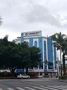

As of 2016, Mangshinominal GDPwas CN¥ 9.628 billion, about 0.65% of the province's GDP, ranking 44th among county-level administrative units in Yunnan; its nominal GDP per capita was CN¥ 23,307, 66th in the province, lower than Yunnan average (CN¥ 30,949).[1]: 522, 524
In 1958, Yunnan government regulated trade in border areas, and thetown of Mangshiwas excluded from the zone of border trade.[20]: 211 In 1980, province government openedManghai(Mang hải), Mangbing (Mang bính) andXiaogai(Tiểu nhai) as border trade markets.[20]: 201 AfterHu Yaobang,theGeneral Secretary of the Chinese Communist Partyinspected Dehong prefecture in 1985, Mangshi abolished all border checkpoints, and made the whole territory a border trade zone.[21]: 645 The border trade and othertertiary sectorswas prosperous in the 1990s. The proportion ofthree industrial sectorsin 1978 was 65.6: 16.3: 18.1,[21]: 647 and in 2016, 23.2: 20.5: 56.3.[1]: 524
Asian rice,sugarcane,tea,coffee,macadamia nutand fruits (banana,pineapple,mango,jackfruitetc.) are the main agricultural products of Mangshi, especially coffee. Mangshi has 19,056 ha. ofpaddy field,9,165 ha. of sugarcane field, 7,504 ha. of macadamia forest, 5,870 ha. of coffee field and 5,469 ha. of fruit field in 2018.[22]Asian Coffee Associationwas established at Mangshi in 2017.[23]13 countries are members of the association.[24]Hogood Coffeeis the largest domesticinstant coffeeproducer in China,[25]and the 10th largestcivilian-run enterpriseof Yunnan.[26]
Population
[edit]| Year | Pop. | ±% p.a. |
|---|---|---|
| 1919 | 49,105 | — |
| 1932 | 39,618 | −1.64% |
| 1947 | 50,832 | +1.68% |
| 1953 | 109,718 | +13.68% |
| 1964 | 152,763 | +3.05% |
| 1982 | 244,411 | +2.65% |
| 1990 | 292,183 | +2.26% |
| 2000 | 337,406 | +1.45% |
| 2010 | 389,891 | +1.46% |
| Source:Annals of Luxi Countyetc.[10]: 40–41 [27][28]: 6 | ||
In 2016, Mangshi had a total population of 415,700 over the whole county-level city,[1]: 533 of which 171.2 thousand resided in the city core, thesubdistrictofMenghuan.[29]
According to the2010 census,Mangshi has 204,083Hancitizens, 52.34% of total population. Othermain ethnicitiesareDaiandJingpo,which has a population with 132,421 and 29,208.[28]: 101–121 Mangshi has the largest number ofPalaung peoplein any county-level subdivision of China, with a population of 9,986,[28]: 101–121 which mainly live inSantaishan Palaung Ethnic Township.[Note 1][10]: 39
Historically,Dai peoplelived in the plains.[10]: 420 Jingpo peopleimmigrated to the mountains from theTibetan Plateauin the 16th century.[10]: 425 Han Chinese became the majority because of theMing conquest of Yunnanand severalSino-Burmese wars,and the subsequent stationing of Chinese army in the area.[5]: 227
Culture
[edit]

Dai peoplein Mangshi speakTai Nuea language,[10]: 420 whileJingpo peoplespeakZaiwaandJingpho.Zaiwa is the most populous branch of Jingpo in Mangshi.[10]: 426
Almost all the Dai andPalaung peoplefollowsTheravada Buddhism.Many villages have their own Buddhist temple,[10]: 422 called "Zhuangfang"(TrangPhòng) or "Miansi" (MiếnTự;'Burmese temple'). They are the center for religion activities and education, and also the entertainment venues for villagers.[30]: 154, 156 Expenditure of the temple and the monk life costs are paid by the villagers. An average Dai farmer spends one-fifth of his annual income for religion-related activities in 1988.[10]: 422 In Jingpo folk religion, various gods as well as ancestral spirits are worshipped.[10]: 451
Water-Sprinkling Festival(in Thailand called "Songkran") andManauare the grandest festivals of the Dai and Jingpo. They are both statutory holidays in Dehong Prefecture.[31]The 15,000-capacityDehong Stadium,a football stadium, is also used for cultural events.[citation needed]
Transport
[edit]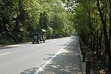
TusiFang Keming (Phương khắc minh) of Mangshi and Duo Jianxun (Đa kiến huân) of Zhefang built a road linking Mangshi andWandingin 1926. An Indian engineer was invited to design the route. The road was completed in 1931, and became a part of theBurma Roadin 1937.[10]: 152 In modernChina National Highways network,this road is part ofG320 Highway.[32]: 42 Longling-Ruili Expresswayopened on 31 December 2015, and is the firstexpresswayof Mangshi. It forms part ofG56 Hangzhou–Ruili ExpresswayandAH14.[33]A provincial highway,Mangshi-Lianghe Expresswayis currently under construction.[34]Another provincial expressway,Ruili-Menglian Expressway,is planned.[35]
Although Mangshi has a 68.23 km-long borderline with Myanmar, it has no nationalport of entry.There are threeborder crossingwithout customs control into Myanmar serving the locals. They are Manghai (Mang hải), Zhongshan (Trung sơn) and Bangda (Bang đạt).[36]: 162 Manghai linksMong Koin Myanmar, also known as Monekoe.
Dali–Ruili railwayis under construction, with two stations in Mangshi:MangshiandMangshi West.[37]
Dehong Mangshi International Airportis the only airport in Dehong Prefecture. It saw 1,652,533 passengers and 13,982 flights in 2017.[38]
Society
[edit]Dehong Sports Centeris located on the west of Mangshi, with a 21,000-capacity stadium, a 3,200-capacity basketball gym, a 2,150-capacity aquatics center, a 6-courts tennis gym and other outdoor sports fields. The sports center was built in 2008, and has a building area of 36,813.49m2.[39]
Dehong People's Hospitalis aTertiary B-levelhospital established in 1954 in southeast of Mangshi.[21]: 551 It has 1,200 beds and the service area covered up Dehong,Longling,Tengchongand part ofMyanmar.[40]
Dehong Teachers' College(Đức hoành sư phạm cao đẳng chuyên khoa học giáo) is the mainhigher educationcollege of Dehong, established in 2006.[21]: 491 It is a technical college but under the working for upgrade to anundergraduate educationuniversity.[41]Many Burmese students are studying abroad in the college.[42]
Dehong's media is multilingual, reflecting its diverse ethnic makeup. Dehong TV Station was established in 1991, with programs inChinese,Tai Nuea,JingphoandZaiwa.Dehong TV Station is the only TV station that uses four languages in China.[21]: 522 Dehong Unity News(Đức hoành đoàn kết báo) is the official newspaper of Dehong Prefecture Committee of the Chinese Communist Party. The newspaper using five languages:Chinese,Tai Nuea,Jingpho,ZaiwaandLisu.It is the only newspaper that uses five languages in China.[21]: 518 Pauk-Phaw,the first Burmese newspaper of China, was founded in Mangshi in 2015 and is published byDehong Unity Newspaperoffice. It serves the 50,000 Burmese who live in China.[43]
Tourism
[edit]

3.3 million tourists visited Mangshi in 2015, and generated a tourism income of CN¥ 5.09 billion for the city.[4]Puti Temple,[44]Wuyun TempleandFoguang Templeare well knownBuddhist templesin Mangshi.[30]: 155 Tiecheng Pagoda,Fengping PagodaandMenghuan Pagodaare well knownBuddhist pagodas.[10]: 462 Tiecheng Pagoda, also known as "Shubao Pagoda" (Chinese:ThụBaoTháp;lit.'pagoda wrapped by tree'), was built inQianlong era,Qing dynasty.A seed fell in the crack of the pagoda about 200 years ago, and now, the pagoda is wrapped by thebodhi tree.[45]: 262 [30]: 53 Mengbanaxi Exotics Garden,a garden for valuable ancient trees and tree fossils, is the only AAAA state-level tourist destination of Mangshi.[46]
Friendly cities
[edit]Mangshi currently maintains friendship agreements with the following foreign
 Gangneung,Gangwon-do,South Korea[47]
See also
[edit]Notes
[edit]- ^Other major area of Palaung people in China:Zhenkang County(2,374),Ruili City(1,783),Longchuan County(1,454),Gengma County(1,158),Longyang District(1,075)
References
[edit]- ^abcdLi Cheng ( lý xanh ) (2012).《 vân nam thống kế niên giám 2017》[Statistical Yearbook of Yunnan 2017] (in Chinese).Beijing:China Statistics Press.ISBN978-7-5037-8267-1.
- ^"Đức hoành châu đệ thất thứ toàn quốc nhân khẩu phổ tra chủ yếu sổ cư công báo"(in Chinese). Government of Dehong Prefecture. 11 June 2021.
- ^abQuốc vụ viện chính thức phê phục đồng ý lộ tây canh danh vi mang thị(in Chinese). Yunnan Xinhua. 23 July 2010. Archived fromthe originalon 25 July 2010.Retrieved4 December2010.
- ^abMang thị thị tình khái huống[Overview of Mangshi].www.dhms.gov.cn(in Chinese). Mangshi government. 29 June 2016.Retrieved3 August2018.
- ^abcdeĐức hoành thái tộc cảnh pha tộc tự trị châu chí biên toản ủy viên hội (1994).《 đức hoành châu chí · tổng hợp quyển 》[Annals of Dehong Prefecture · Integrated Volume] (in Chinese). Mangshi: Dehong Nationalities Publishing House.ISBN7-8052-5248-3.
- ^Yos Santasombat (2008).Lak Chang: A reconstruction of Tai identity in Daikong.Canberra:ANU Press.ISBN978-1740760812.
- ^Wei Yinxia ( ngụy ngân hà ) (28 September 2010).Vân nam tỉnh đức hoành châu châu phủ lộ tây thị chính thức canh danh vi "Mang thị"[Luxi,the capital of Dehong Prefecture in Yunnan, official name change to Mangshi].Khổng tước chi hương võng(in Chinese). Mangshi.Retrieved24 July2018.
- ^Đức hoành thái tộc cảnh pha tộc tự trị châu chí biên toản ủy viên hội (2017).《 đức hoành niên giám 2017》[Yearbook of Dehong 2017] (in Chinese). Mangshi: Dehong Nationalities Publishing House. p. English Contents page1.ISBN978-7-5558-0726-1.
- ^abĐức hoành châu chính hiệp văn sử hòa học tập ủy (1997).《 đức hoành châu văn sử tư liêu tuyển tập đệ thập tập ( đức hoành thổ tư chuyên tập ) 》[Compilation of History Reference of Dehong Prefecture - 10th volume (Dehong Tusi volume)] (in Chinese). Mangshi: Dehong Nationalities Publishing House.ISBN7-80525-340-4.
- ^abcdefghijklmnopVân nam tỉnh lộ tây huyện chí biên toản ủy viên hội (1993).《 lộ tây huyện chí 》[Annals of Luxi County] (in Chinese).Kunming:Yunnan Education Publishing House.ISBN7-5415-0685-0.
- ^abMinistry of Civil Affairs(2016).《 trung hoa nhân dân cộng hòa quốc chính khu đại điển vân nam quyển 》[People's Republic of China Administrative Divisions Encyclopedia Yunnan Volume] (in Chinese).Beijing:China Social Publisher.ISBN978-7-5087-5306-5.
- ^Trung cộng vân nam tỉnh ủy chính sách nghiên cứu thất; vân nam tỉnh chí biên toản ủy viên hội bạn công thất (1986).《 vân nam địa châu thị huyện khái huống đức hoành thái tộc cảnh pha tộc tự trị châu phân sách 》[Overview of Prefecture, city and county of Yunnan·Dehong Dai and Jingpo Autonomous Prefecture Volume] (in Simplified Chinese).
- ^"Mangshi River".en.dehong.gov.cn.Dehong.Gov. 24 September 2013.Retrieved21 May2018.
- ^Jing Zhengshu ( kính chính thư ) (2010).《 trung quốc hà hồ đại điển tây nam chư hà quyển 》[China Rivers and Lakes Encyclopedia].Beijing:China Water&Power Press.ISBN978-7-5170-2699-0.
- ^Trung quốc khí tượng sổ cư võng – WeatherBk Data(in Simplified Chinese).China Meteorological Administration.Retrieved9 April2023.
- ^ "Experience Template"Trung quốc khí tượng sổ cư võng(in Simplified Chinese).China Meteorological Administration.Retrieved9 April2023.
- ^"Quốc gia thống kế cục"(in Chinese). National Bureau of Statistics of the People's Republic of China.Retrieved7 December2021.
- ^2017 niên thống kế dụng khu hoa đại mã hòa thành hương hoa phân đại mã ( tiệt chỉ 2017 niên 10 nguyệt 31 nhật )>>533103000 mang thị[Administrative division codes of the People's Republic of China, 2017 >> 533103000 Mangshi] (in Chinese).National Bureau of Statistics of China.Retrieved27 July2018.
- ^Quốc vụ viện nhân khẩu phổ tra bạn công thất; quốc gia thống kế cục nhân khẩu hòa tựu nghiệp thống kế tư (2012).《 trung quốc nhân khẩu phổ tra phân hương, trấn, nhai đạo tư liêu 》[Townships, Towns and Subdistricts Reference of China Census].Beijing:China Statistics Press.ISBN978-7-5037-6660-2.
- ^abĐức hoành sử chí biên toản ủy viên hội (1997).《 đức hoành châu chí · kinh tế quyển 》[Annals of Dehong Prefecture · Economy Volume]. Mangshi: Dehong Nationalities Publishing House.ISBN7-80525-398-6.
- ^abcdef《 đức hoành cải cách khai phóng 30 niên 》 biên ủy hội (2008).《 đức hoành cải cách khai phóng 30 niên 》[30 Years of Dehong since Economic Reform]. Mangshi: Dehong Nationalities Publishing House.ISBN978-7-80750-133-6.
{{cite book}}:CS1 maint: numeric names: authors list (link) - ^Liu Xiangyuan ( lưu tường nguyên ) (29 March 2018).Mang thị gia đại chiêu thương dẫn tư lực độ[Mangshi Increase Investment Working].yndaily.yunnan.cnVân nam nhật báo(in Chinese).Retrieved2 August2018.
- ^"The Asian Coffee Association established in Mangshi".en.dehong.gov.cn.Dehong Government. 4 December 2017.Retrieved2 August2018.
- ^"Vietnam joins management board of Asian Coffee Association".english.vov.vn.THE VOICE OF VIETNAM ONLINE. 28 November 2017.Retrieved2 August2018.
- ^"Case Study"(PDF).
- ^Zhao Gang ( triệu cương ) (2 August 2018).Nhập vi môn hạm 7.45 ức 2018 vân nam phi công xí nghiệp bách cường công bố tuấn phát tập đoàn 471 ức bài đệ nhất[Finalist threshold is 745 million Chinese yuan, list of 100 largest civilian-run enterprises of Yunnan 2018 has published, Junfa Group is the top 1 with 47.1 billion worth].yn.yunnan.cnVân nam võng(in Chinese).Retrieved2 August2018.
- ^Biểu 1 tổng nhân khẩu, hộ tịch nhân khẩu, thiếu sổ dân tộc nhân khẩu bỉ trọng, phi nông nghiệp hộ khẩu nhân khẩu bỉ trọng, thành hương nhân khẩu, gia đình hộ nhân khẩu, gia đình hộ loại biệt ( toàn bộ sổ cư ).www.dhms.gov.cn(in Chinese (China)).National Bureau of Statistics of China.Retrieved13 May2020.
- ^abcLuo Jinzhong ( la tiến trung ) (2012).《 vân nam tỉnh 2010 niên nhân khẩu phổ tra tư liêu 》[People Census Reference of Yunnan 2010] (in Chinese).Beijing:China Statistics Press.ISBN978-7-5037-6548-3.
- ^Mãnh hoán nhai đạo khái huống[Overview of Menghuan Subdistrict].www.dhms.gov.cn(in Chinese). Mangshi government. 26 March 2018.Retrieved3 August2018.
- ^abcZhang Fangyuan ( trương phương nguyên ) (2000).《 tân biên đức hoành phong vật chí 》[Annals of Dehong Prefecture · Economy Volume]. Kunming: Yunnan People's Publishing House.ISBN7-222-02968-0.
- ^Ngã quốc phổ biến pháp định tiết giả nhật hữu 7 cá, nhi giá ta thiếu sổ dân tộc đích tiết giả nhật khước bất chỉ[There are 7 statutory holidays in China, but in minority area are more than 7].Tuyết hoa tân văn(in Chinese). 17 March 2018.Retrieved3 August2018.
- ^Đức hoành thái tộc cảnh pha tộc tự trị châu giao thông cục (1999).《 đức hoành châu giao thông chí 》[Annals of Transportation of Dehong Prefecture].Kunming:Yunnan National Publisher.ISBN7-5367-1188-3.
- ^Liu Xiangyuan ( lưu tường nguyên ); Wang Yunrui ( vương vân thụy ) (1 January 2016).Long thụy cao tốc toàn tuyến kiến thành thông xa côn minh đáo thụy lệ thật hiện toàn trình cao tốc[Longling-Ruili Expressway opened the whole of line, Kunming to Ruili realized entire journey with expressway].www.yndaily.com(in Chinese). Yunnan Daily Newspaper.Retrieved28 July2018.
- ^Cui Wen ( thôi vấn ) (30 March 2017).Trung miến biên cảnh mang thị chí lương hà cao tốc công lộ khai kiến[China-Myanmar border Mangshi-Lianghe Expressway started construction].www.chinanews.com(in Chinese).China News Service.Retrieved28 July2018.
- ^Wang Lei ( vương lỗi ) (5 December 2017).Thụy lệ chí mạnh liên tương kiến cao tốc[China-Myanmar border Mangshi-Lianghe Expressway started construction].xw.kunming.cnXuân thành vãn báo(in Chinese).Retrieved28 July2018.
- ^Yang Hong (2015).Điền tây biên cảnh huyện nghiên cứu thư hệ mang thị(in Chinese (China)).Kunming:Yunnan UniversityPress.ISBN978-7-5482-2412-9.
- ^Toàn diện thôi tiến | đại thụy thiết lộ đức hoành đoạn kiến thiết trình hiện xuất đại công địa, đại kiến thiết thái thế[Construction of Dali–Ruili railway Dehong part showing the big construction situation] (in Chinese (China)). Dehong Prefecture People's Government. 19 March 2018.Retrieved28 July2018.
- ^2017 niên 1-12 nguyệt tây nam địa khu cơ tràng sinh sản thống kế giản báo[Production Statistics Briefing of Airports in Southwest China during January to December in 2017].info.swcaac.gov.cn(in Chinese).Civil Aviation Administration of China.31 January 2018. Archived fromthe originalon 17 September 2017.Retrieved28 July2018.
- ^Đức hoành châu thể dục vận động trung tâm —— vận động hưu nhàn đích nhạc viên[Dehong Sports Center, the paradise of sports and leisure].www.sohu.com(in Chinese). Sports Dehong. 18 April 2018.Retrieved3 August2018.
- ^Y viện khái huống[Overview of Hospital].www.dhzyy.com(in Chinese). Dehong People's Hospital.Retrieved3 August2018.
- ^Toàn quốc chính hiệp hội thượng đích đức hoành thanh âm[Dehong Voice on the CPPCC].www.dehongzx.com(in Chinese). Dehong People's PCC. 12 March 2018.Retrieved3 August2018.
- ^Miến điện lưu học sinh đổng minh quân: Ngã tưởng khảo trung quốc đích đại học, học canh đa đích nông nghiệp tri thức[Myanmar international student Dong Mingjun: I want go to university in China, and learn more agricultural technology].www.dehong.gov.cn(in Chinese). Dehong Prefecture People's Government. 27 April 2018.Retrieved3 August2018.
- ^Yao Bing ( diêu binh ) (6 December 2015).Trung quốc thủ phân miến văn báo chỉ 《 bào ba 》 tại vân nam đức hoành sang khan[First Burmese NewspaperPauk-Phawhas founded in Dehong, Yunnan].Xinhua News Agency(in Chinese). Archived fromthe originalon 4 August 2018.Retrieved4 August2018.
- ^Zi Yan (2012).Famous Temples in China(in English and Chinese). Hefei, Anhui: Huangshan Publishing House. pp. 171–172.ISBN978-7-5461-3146-7.
- ^《 đức hoành thái tộc cảnh pha tộc tự trị châu khái huống 》 biên tả tổ (2008).《 đức hoành thái tộc cảnh pha tộc tự trị châu khái huống 》[Overview of Dehong Dai and Jingpo Autonomous Prefecture].Beijing:Publishing House of Minority Nationalities.ISBN978-7-10508-592-7.
- ^"Mengbanaxi Exotic Garden Travel Guide".Discover China Tours.Retrieved4 August2018.
- ^Hàn quốc giang lăng thị nghị hội đại biểu đoàn đáo mang thị tiến hành hữu hảo giao lưu[Mission of Gangneung City Council conduct friendly exchanges in Mangshi].www.ynmsrd.com(in Chinese). Mang thị nhân đại thường ủy hội. 19 October 2014.Retrieved29 July2018.


