
Manilaid
| Geography | |
|---|---|
| Location | Gulf of Riga |
| Coordinates | 58°12′49″N24°07′16″E/ 58.21361°N 24.12111°E |
| Administration | |
| County | Lääne County |


Manilaidis a 1.87 km2(0.72 sq mi)Estonianisletin theGulf of Riga,located between the island ofKihnuand the mainland's Tõstamaa peninsula. Together with the neighbouring smaller uninhabited isletsSorguandAnnilaid,Manilaid forms the village ofManija.Administratively the village belongs toPärnu municipalityinPärnu County.
The island was unpoplulated until 1933, when about 80 residents moved to Manilaid from the neighbouringKihnu.At its peak, there were about 150 residents on the island. During the Soviet era, the population decreased. On January 1, 2011, Manilaid's population was 47.[1]
Manilaid has a ferry connection with theMunalaiu harbouron the mainland. In the winter, when theGulf of Rigais covered with ice, the island is reachable byice bridge.
Gallery[edit]
-
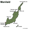 Map of Manilaid
 -
 Village centre
 -
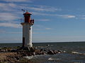 Lighthouse
 -
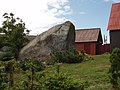 Kokkõkivi,the largestglacial erraticin Pärnu County.


See also[edit]
References[edit]
- ^"Külad"(in Estonian). Tõstamaa vald. Archived fromthe originalon 20 September 2011.Retrieved23 May2011.
ThisPärnu Countylocation article is astub.You can help Wikipedia byexpanding it. |