
Mariehamn
Mariehamn | |
|---|---|
| Mariehamns stad Town of Mariehamn | |
       Västerhamn ferry terminal, Ålands Lagting, Havsgatan street, Consulate General of Sweden, Saint George church, Ålands Lyceum, the Sails Pavilion | |
 Flag  Seal  Coat of arms | |
| Nickname: De tusen lindarnas stad (The town of a thousand linden trees)[1] | |
 Location of Mariehamn in Finland | |
 Mariehamn Location within the Åland Islands | |
| Coordinates:60°06′N019°56′E/ 60.100°N 19.933°E | |
| Country | |
| Region | Åland |
| Sub-region | Mariehamn sub-region |
| Charter | 21 February 1861[2] |
| Named for | Maria Alexandrovna |
| Government | |
| • Mayor | Arne Selander |
| Area (2018-01-01)[3] | |
| • Total | 20.75 km2(8.01 sq mi) |
| • Land | 11.81 km2(4.56 sq mi) |
| • Water | 8.96 km2(3.46 sq mi) |
| • Rank | 311th largestin Finland |
| Population (2024-08-31)[4] | |
| • Total | 11,875 |
| • Rank | 86th largestin Finland |
| • Density | 1,005.5/km2(2,604/sq mi) |
| Population by native language | |
| •Swedish | 81.5% (official) |
| •Finnish | 4.9% |
| • Others | 13.6% |
| Population by age | |
| • 0 to 14 | 14.2% |
| • 15 to 64 | 60.9% |
| • 65 or older | 24.9% |
| Time zone | UTC+02:00(EET) |
| • Summer (DST) | UTC+03:00(EEST) |
| Postal code | 22100, 22101, 22110, 22111, 22120, 22140, 22160[7] |
| Website | www.mariehamn.ax |
Mariehamn(/məˈriːəhɑːmən/mə-REE-ə-hah-mən,[9]Finland Swedish:[mɑriːeˈhɑmn];Finnish:Maarianhamina[ˈmɑːriɑnˌhɑminɑ];Latin:Portus Mariae) is thecapitalofÅland,an autonomous territory underFinnishsovereignty.Mariehamn is the seat of theGovernmentandParliament of Åland,and 40% of the population of Åland live in the city. It is mostly surrounded byJomala,the second-largest municipality in Åland in terms of population; to the east, it is bordered byLemland.Like the rest of Åland, Mariehamn is unilinguallySwedish-speakingand around82% of the inhabitants speak it as their native language.[5]
The theme of thecoat of armsof Mariehamn refers to the city's main livelihood,maritime transport,and the city's parks, which are typically lined withlinden trees.[10][11][12][13]The coat of arms was designed by Nils Byman and confirmed in 1951.[14]
Due to its central location in theBaltic Sea,Mariehamn has become a major summerresort townfor globaltourism;as many as 1.5 million tourists visit annually.[15][16][17]
History
[edit]This sectionneeds expansion.You can help byadding to it.(June 2022) |

The town was named after the Russian empressMaria Alexandrovna(1824–1880), literally meaning "Marie's Port". Mariehamn was founded on 21 February 1861 around the village ofÖvernäs,[2][18]in what was at the time part of the municipality ofJomala.The city has since expanded and incorporated more of Jomala territory. Mariehamn was built according to a very regular scheme which is well-preserved. One of the oldest streets isSödragatanwhere many wooden houses dating from the 19th century can be seen.
Following theFirst World War,Mariehamn was home to the Mariehamn Grain Fleet.[19]
On November 8, 1963, adevastating plane crashoccurred in Mariehamn, in which 22 out of 25 people lost their lives, which made it the second-deadliest aviation accident in the history of Finland.[20]
Transportation
[edit]Harbours
[edit]The city is located on apeninsula.It has two important harbours, one located on the western shore and one on the eastern shore, which are ice-free for nearly the whole year, and have no tides.[21]TheWestern Harbouris an important international harbour with daily traffic toSweden,Estoniaand mainlandFinland.A powerful incentive for Baltic ferries to stop at Mariehamn is that, with respect to indirect taxation, Åland is not part of theEU customs zoneand so duty-free goods can be sold aboard. Åland and Mariehamn have a reputable heritage in shipping. TheFlying P-LinerPommernmuseum ship(part of theÅland Maritime Museum) is anchored in the Western Harbour. The Eastern Harbour features one of the largest marinas inScandinavia.The famous Dutch steamerJan Nieveen(now calledF.P. von Knorring,after Åland teacher and vicarFrans Peter von Knorring) can also be found here.
Airport
[edit]Mariehamn Airportserves the city; it has scheduled flights on two airlines includingFinnair.
Roads
[edit]At three of Åland's four highways, Mariehamn serves as a starting point forMain Road 1toEckerö,Main Road 2toSundandMain Road 3toLumparland.
Culture
[edit]The city is an important centre for Åland media; both of the local newspapers (ÅlandstidningenandNya Åland), several radio stations and the local TV channels (TV ÅlandandÅland24) operate out of the city. The islanders are traditionally fond of reading, and had public libraries before 1920. A printing works was established in the town in 1891.[21]The municipal library, which was built in 1989, is one of the most interesting modern buildings.
Museums
[edit]Architecture
[edit]Architects
[edit]Mariehamn features several buildings drawn by Finnish architectLars Sonck,who moved to Åland as a child. Buildings drawn by him include the church of Mariehamn (1927), the main building of theÅland Maritime College(1927) and the town hall (1939).Hilda Hongellalso designed several buildings, although only a few are still standing.
The Church of St George
[edit]The main parish church of Mariehamn was opened in 1927 and has been expanded in 1959 and renovated in 1972. when the pews were painted blue. The visible decorations include painted wooden ceiling panels, one for each of the followers of Christ. The unnamed panel is that representing Judas Iscariot. The church paintings and decorations are the work of Finnish artist Bruno Tuukkanen. These include the golden mosaics behind the altar which show the life of Christ. Gifts to the church include the font and the ship that hangs from the ceiling. This is theTjerimaj.The church houses a 37 stop organ built in stages (1969, 1982).[22]
Demographics
[edit]
|
|
| |||||||||||||||||||||||||||||||||||||||||||||||||||||||||||||||
| Source: ÅSUB's statistical databases[23] | |||||||||||||||||||||||||||||||||||||||||||||||||||||||||||||||||
| People with a foreign background[24][25] | |
|---|---|
| Country of origin | Population (2018) |
| 1,093 (9.55%) | |
| 173 (1.51%) | |
| 163 (1.42%) | |
| 101 (0.85%) | |
| 92 (0.80%) | |
| 86 (0.75%) | |
| 86 (0.75%) | |
| 73 (0.64%) | |
| 55 (0.48%) | |
| 45 (0.39%) | |
Geography
[edit]Climate
[edit]Mariehamn has a transitional climate between ahumid continental climate(Dfb) and anoceanic climate(Cfb) as a result of the strong maritime moderation from being an island in the Baltic Sea. This causes summers to be cooler than both the Swedish and Finnish mainlands, with winters being similar in cold to the adjacent coastal part of Sweden but milder than Finland's mainland. The lowest temperature at Mariehamn airport was −32.9 °C (−27.2 °F) in February 1979, and the highest temperature on record was 31.3 °C (88.3 °F) in July 2022 and July 1941.[26]
| Climate data for Mariehamn Airport normals 1991-2020, extremes 1914 – present | |||||||||||||
|---|---|---|---|---|---|---|---|---|---|---|---|---|---|
| Month | Jan | Feb | Mar | Apr | May | Jun | Jul | Aug | Sep | Oct | Nov | Dec | Year |
| Record high °C (°F) | 10.9 (51.6) |
10.5 (50.9) |
17.0 (62.6) |
21.1 (70.0) |
27.1 (80.8) |
29.4 (84.9) |
31.3 (88.3) |
30.7 (87.3) |
25.7 (78.3) |
19.0 (66.2) |
16.6 (61.9) |
11.1 (52.0) |
31.3 (88.3) |
| Mean daily maximum °C (°F) | 1.0 (33.8) |
0.4 (32.7) |
3.1 (37.6) |
8.0 (46.4) |
13.4 (56.1) |
17.5 (63.5) |
20.8 (69.4) |
20.0 (68.0) |
15.5 (59.9) |
9.6 (49.3) |
5.2 (41.4) |
2.5 (36.5) |
9.8 (49.6) |
| Daily mean °C (°F) | −1.3 (29.7) |
−2.3 (27.9) |
−0.2 (31.6) |
3.8 (38.8) |
8.9 (48.0) |
13.3 (55.9) |
16.8 (62.2) |
16.1 (61.0) |
11.8 (53.2) |
6.8 (44.2) |
3.2 (37.8) |
0.4 (32.7) |
6.4 (43.5) |
| Mean daily minimum °C (°F) | −4.3 (24.3) |
−5.5 (22.1) |
−3.7 (25.3) |
−0.1 (31.8) |
4.0 (39.2) |
8.6 (47.5) |
12.2 (54.0) |
11.6 (52.9) |
7.8 (46.0) |
3.5 (38.3) |
0.6 (33.1) |
−2.5 (27.5) |
2.7 (36.9) |
| Record low °C (°F) | −32.3 (−26.1) |
−32.9 (−27.2) |
−25.0 (−13.0) |
−18.9 (−2.0) |
−6.5 (20.3) |
−3.2 (26.2) |
0.1 (32.2) |
−0.5 (31.1) |
−6.7 (19.9) |
−11.8 (10.8) |
−20.0 (−4.0) |
−28.9 (−20.0) |
−32.9 (−27.2) |
| Averageprecipitationmm (inches) | 53 (2.1) |
35 (1.4) |
38 (1.5) |
31 (1.2) |
35 (1.4) |
53 (2.1) |
52 (2.0) |
76 (3.0) |
61 (2.4) |
70 (2.8) |
71 (2.8) |
59 (2.3) |
634 (25) |
| Average precipitation days | 17 | 13 | 12 | 9 | 10 | 10 | 9 | 13 | 12 | 16 | 17 | 17 | 155 |
| Mean monthlysunshine hours | 39 | 74 | 130 | 207 | 297 | 296 | 312 | 235 | 163 | 91 | 41 | 26 | 1,911 |
| Source 1: FMI climatological normals for Finland 1991–2020[27] | |||||||||||||
| Source 2: record highs and lows 1961 – present[28] | |||||||||||||
Twin towns and sister cities
[edit]Mariehamn is twinned with:[29]
 Kópavogur,Iceland
 Kragerø,Norway
 Kuressaare,Estonia
 Lomonosov,Russia(cooperation paused due toRussian invasion of Ukraine)[30]
 Slagelse,Denmark
 Tórshavn,Faroe Islands
 Valkeakoski,Finland
 Visby,Sweden
Notable people
[edit]- Gustaf Erikson(1872–1947), ship-owner, operated a fleet ofwindjammers
- Maggie Gripenberg(1881–1976), dancer and choreographer
- Georg Kåhre(1899–1969), a teacher and author; he wrote poetry and prose
- Henrik Klingenberg(born 1978), keyboardist,keytaristand singer ofSonata Arctica
- Stefan Lindfors(born 1962), an industrial & interior designer, film-maker and sculptor.
- Ville Salminen(1908–1992), film actor and director
Sport
[edit]- Adelina Engman(born 1984), footballer
- Anders Överström(born 1985), professional footballer
- Olivia Ulenius(born 2007), footballer
- Tommy Wirtanen(born 1983), semi-professional footballer
Gallery
[edit]-
 Aerial view of Mariehamn.
 -
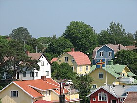 Wooden houses of Mariehamn.
 -
 Södragatan,one of the oldest streets of Mariehamn.
 -
![St. George's Church [sv].](https://upload.wikimedia.org/wikipedia/commons/thumb/4/42/Mariehamn_Church.jpg/157px-Mariehamn_Church.jpg)
-
 Ålandsvägen,a typical street in Mariehamn, withlinden trees.
 -
 An esplanade alongStoragatan.
 -
 The museum shipPommernis anchored in the western of Mariehamn's two harbours,Västerhamn.
 -
 Nordeabank office in Mariehamn.
 -
 Åland Museum in Mariehamn.
 -
 Municipal library of Mariehamn.


![St. George's Church [sv].](/translate/en.wikipedia.org?u=https%3A%2F%2Fen.wikipedia.org%2Fwiki%2FFile%3AMariehamn_Church.jpg&t=hv)


See also
[edit]References
[edit]- ^"Turism - Mariehamns stad".Mariehamns stad.Retrieved23 January2020.
- ^ab"Sjöfarts promenaden: Upptäck Mariehamn till fots"(PDF)(in Swedish). City of Mariehamn.Retrieved21 February2024.
- ^"Area of Finnish Municipalities 1.1.2018"(PDF).National Land Survey of Finland.Retrieved30 January2018.
- ^"Finland's preliminary population figure was 5,625,011 at the end of August 2024".Population structure. Statistics Finland. 2024-09-24.ISSN1797-5395.Retrieved2024-09-25.
- ^ab"Population growth biggest in nearly 70 years".Population structure. Statistics Finland. 2024-04-26.ISSN1797-5395.Retrieved2024-04-29.
- ^"Population according to age (1-year) and sex by area and the regional division of each statistical reference year, 2003–2020".StatFin.Statistics Finland.Retrieved2 May2021.
- ^"Åland Islands Postal codes".postal.codesofcountry.com.Retrieved27 February2024.
- ^ab"Luettelo kuntien ja seurakuntien tuloveroprosenteista vuonna 2023".Tax Administration of Finland. 14 November 2022.Retrieved7 May2023.
- ^"Mariehamn".Merriam-Webster.com Dictionary.Merriam-Webster.RetrievedDecember 28,2020.
- ^Suomen kunnallisvaakunat(in Finnish). Suomen Kunnallisliitto. 1982. p. 171.ISBN951-773-085-3.
- ^"Ahvenanmaan kuntien vaakunat 1947-1987 (I:15) Maarianhamina"(in Swedish). Kansallisarkiston digitaaliarkisto.RetrievedMarch 25,2021.
- ^"Ennen 8.4.1949 annettua kunnanvaakunalakia vahvistetut vaakunat (I:7) Maarianhamina".Kansallisarkiston digitaaliarkisto(in Swedish).RetrievedMarch 25,2021.
- ^"Mariehamns vapen"(in Swedish). City of Mariehamn.RetrievedMarch 25,2021.
- ^Mitä-Missä-Milloin, Kansalaisen vuosikirja 1980(in Finnish). Helsinki: Otava. 1979. p. 165.
- ^Mariehamn – Visit Åland
- ^Tourism Mariehamn & Mariehamn Travel Guide– Discovering Finland
- ^Åland: many travellers, far fewer overnighters– Nordic Labour Journal
- ^Mann, Robert (2011). Żaboklicki, Paweł (ed.). "Mariehamn Celebrates".Union of the Baltic Cities(1). The UBC Bulletin: 34.
- ^Derby., W L A (1937)."Mariehamn's Grain Fleet - Shipping Wonders of the World".Shipping Wonders of the World(21 July 1937): 746–749.
- ^Ranter, Harro."ASN Aircraft accident Douglas C-47A-35-DL (DC-3) OH-LCA Mariehamn Airport (MHQ)".aviation-safety.net.Aviation Safety Network.Retrieved2020-07-12.
- ^abProthero, G.W.(1920).The Åland Islands.Great Britain. Foreign Office. Historical Section. p. 5.
- ^The Church of St Goran (St George),(anonymous) parish leaflet (2011) Mariehamns Tryckeri Ab
- ^"PX-Web - Select variable and values".
- ^http://pxnet2.stat.fi/PXWeb/pxweb/fi/StatFin/StatFin__vrm__vaerak/statfin_vaerak_pxt_032.px/table/tableViewLayout2/?rxid=726cd24d-d0f1-416a-8eec-7ce9b82fd5a4[dead link]
- ^"PX-Web - Valitse muuttuja ja arvot".Archived fromthe originalon 2018-06-29.Retrieved2018-09-26.
- ^ab"Suomen maakuntien ilmasto"(PDF).helda.helsinki.fi.
- ^"FMI normals 1991-2020"(PDF).fmi.fi.Retrieved26 April2016.
- ^"FMI open data".FMI.Retrieved26 April2016.
- ^Mariehamns stads vänorter.Archived2015-09-21 atarchive.todayAccessed July 14, 2015
- ^"Dags att avbryta ryskt vänortssamarbete helt?".Nya Åland(in Swedish).Retrieved2023-03-31.
External links
[edit]![]() Media related toMariehamnat Wikimedia Commons
Media related toMariehamnat Wikimedia Commons
- Official website(in Swedish)
- Official Tourist Gateway of Mariehamn - Maarianhamina
 Mariehamntravel guide from Wikivoyage
- Map of Mariehamn
- Mariehamn. Tourist route(in Russian)
Places adjacent to Mariehamn | ||||||||||||||||
|---|---|---|---|---|---|---|---|---|---|---|---|---|---|---|---|---|
| ||||||||||||||||
| International | |
|---|---|
| National | |
| Geographic | |