Matsumae, Hokkaido
This article includes a list ofgeneral references,butit lacks sufficient correspondinginline citations.(June 2017) |
Matsumae
Tùng tiền đinh | |
|---|---|
Town | |
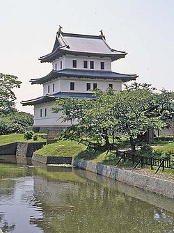
 Matsumae Castle (July 2004) | |
 Location of Matsumae inOshima Subprefecture,Hokkaido | |
| Coordinates:41°26′N140°7′E/ 41.433°N 140.117°E | |
| Country | Japan |
| Prefecture | Hokkaido |
| District | Matsumae |
| Government | |
| • Mayor | Hideo Ishiyama(Thạch sơn anh hùng) |
| Area | |
| • Total | 293.11 km2(113.17 sq mi) |
| Population (2016) | |
| • Total | 7,843 |
| • Density | 27/km2(69/sq mi) |
| Time zone | UTC+09:00(JST) |
| Postal code(s) | 049-1592 |
| Area code | 0139 |
| City hall address | Aza Fukiyama 248, Matsumae-chō, Matsumae-gun, Hokkaidō 049-1592 |
| Climate | Cfa |
| Website | www |
| Symbols | |
| Flower | Cherry blossom |
| Tree | Pine |
Matsumae(Tùng tiền đinh,Matsumae-chō)is atownlocated inOshima Subprefecture,Hokkaido,Japan.The former home of the MatsumaeHan,it has anEdo periodcastle,Matsumae Castle,the only one in Hokkaido, andRyūun-in.
The total area of the town is 293.11 square kilometres (113.17 sq mi).
History
[edit]
- 1900: Fukuyama town was founded.
- 1940: Fukuyama changed its name to Matsumae.
- 1953: Matsumae Line opened.
- 1954: Matsumae town, Oshima village, Osawa village, and Kojima village were merged to form Matsumae town.
- 1988: Matsumae Line was abolished.[1]
Geography
[edit]The town is located on the southern end of theMatsumae Peninsula.In addition the town governs the two islands in theTsugaru Strait,OshimaandKojima.[2]
Along withKaminokuni, Hokkaido,andFukushima, Hokkaido,Matsumae shares a border withMount Daisengen,and contains the newest and shortest climbing route to the summit of the mountain.[3]
Climate
[edit]| Climate data for Matsumae, Hokkaido (1991−2020 normals, extremes 1977−present) | |||||||||||||
|---|---|---|---|---|---|---|---|---|---|---|---|---|---|
| Month | Jan | Feb | Mar | Apr | May | Jun | Jul | Aug | Sep | Oct | Nov | Dec | Year |
| Record high °C (°F) | 11.1 (52.0) |
13.8 (56.8) |
15.3 (59.5) |
23.3 (73.9) |
25.7 (78.3) |
29.3 (84.7) |
33.3 (91.9) |
34.2 (93.6) |
31.5 (88.7) |
24.9 (76.8) |
20.3 (68.5) |
15.8 (60.4) |
34.2 (93.6) |
| Mean daily maximum °C (°F) | 1.9 (35.4) |
2.4 (36.3) |
5.8 (42.4) |
11.0 (51.8) |
15.9 (60.6) |
20.0 (68.0) |
23.7 (74.7) |
25.9 (78.6) |
23.1 (73.6) |
17.3 (63.1) |
10.7 (51.3) |
4.5 (40.1) |
13.5 (56.3) |
| Daily mean °C (°F) | −0.5 (31.1) |
−0.1 (31.8) |
3.0 (37.4) |
7.9 (46.2) |
12.5 (54.5) |
16.6 (61.9) |
20.6 (69.1) |
22.7 (72.9) |
19.8 (67.6) |
14.1 (57.4) |
7.8 (46.0) |
1.9 (35.4) |
10.5 (50.9) |
| Mean daily minimum °C (°F) | −3.0 (26.6) |
−2.7 (27.1) |
0.1 (32.2) |
4.7 (40.5) |
9.4 (48.9) |
13.5 (56.3) |
18.1 (64.6) |
20.0 (68.0) |
16.7 (62.1) |
10.9 (51.6) |
4.8 (40.6) |
−0.7 (30.7) |
7.7 (45.8) |
| Record low °C (°F) | −11.6 (11.1) |
−10.4 (13.3) |
−7.9 (17.8) |
−3.7 (25.3) |
2.2 (36.0) |
6.3 (43.3) |
10.6 (51.1) |
12.6 (54.7) |
7.6 (45.7) |
2.7 (36.9) |
−6.1 (21.0) |
−11.4 (11.5) |
−11.6 (11.1) |
| Averageprecipitationmm (inches) | 87.1 (3.43) |
72.9 (2.87) |
63.9 (2.52) |
73.5 (2.89) |
97.5 (3.84) |
80.0 (3.15) |
124.9 (4.92) |
157.5 (6.20) |
155.2 (6.11) |
115.5 (4.55) |
122.0 (4.80) |
106.0 (4.17) |
1,251.3 (49.26) |
| Average rainy days | 18.4 | 15.5 | 13.3 | 10.3 | 10.2 | 8.7 | 10.4 | 9.8 | 11.5 | 12.4 | 15.7 | 18.9 | 155.1 |
| Mean monthlysunshine hours | 46.9 | 66.7 | 132.3 | 175.7 | 173.4 | 159.2 | 137.4 | 170.3 | 171.1 | 153.3 | 82.1 | 50.1 | 1,518.5 |
| Source 1:JMA[4] | |||||||||||||
| Source 2:JMA[5][6] | |||||||||||||
Demographics
[edit]As of September 2016, the town has an estimated population of 7,843 and a density of 26.7 persons per km2.
Culture and lifestyle
[edit]SurroundingMatsumae Castleis Matsumae Park, which features over 10,000 cherry trees of over 250 varieties, and is ranked among the topcherry blossom viewingspots in the country.[7]
Education
[edit]High school
[edit]- Hokkaido Matsumae High School (the southernmost high school in Hokkaido)[8]
Sister cities
[edit]- Omihachiman, Shiga(since 1984)[9]
- Masaki, Ehime(since 1990)[10]
- Date, Fukushima(since 2011)[11]
References
[edit]- ^Matsumae LineArchived2015-02-27 at theWayback Machine
- ^"gotyuuikudasai"(in Japanese). Tùng tiền đinh dịch tràng. Archived fromthe originalon 15 July 2010.Retrieved30 June2010.
- ^"Đại thiên hiên nhạc tình báo | độ đảo tổng hợp chấn hưng cục sâm lâm thất tây bộ sâm lâm thất".www.oshima.pref.hokkaido.lg.jp.Retrieved2020-07-14.
- ^Quan trắc sử thượng 1~10 vị の trị ( niên gian を thông じての trị ).JMA.RetrievedFebruary 20,2022.
- ^Khí tượng sảnh / bình niên trị ( niên ・ nguyệt ごとの trị ).JMA.RetrievedFebruary 20,2022.
- ^https://twitter.com/extremetemps/status/1618277904043102208[bare URL]
- ^"Matsumae".www.japan-guide.com.Retrieved2020-07-14.
- ^Hokkaido Matsumae High School
- ^Sister cities of Omihachiman
- ^Interaction with sister city, Matsumae
- ^Sister cities of Date
External links
[edit]![]() Media related toMatsumae, Hokkaidōat Wikimedia Commons
Media related toMatsumae, Hokkaidōat Wikimedia Commons
- Official Website(in Japanese)


