
Mesocyclone

| Part ofa serieson |
| Weather |
|---|
|
|
Amesocycloneis a meso-gammamesoscale(or storm scale) region of rotation (vortex), typically around 2 to 6 mi (3.2 to 9.7 km) in diameter, most often noticed on radar withinthunderstorms.In thenorthern hemisphereit is usually located in the right rear flank (back edge with respect to direction of movement) of asupercell,or often on the eastern, or leading, flank of ahigh-precipitationvariety of supercell. The area overlaid by a mesocyclone’s circulation may be several miles (km) wide, but substantially larger than anytornadothat may develop within it, and it is within mesocyclones thatintense tornadoesform.[1]
Description[edit]
Mesocyclones are medium-scale vortices of rising and converging air that circulate around a vertical axis. They are most often associated with a localregion of low-pressure.Their rotationis (usually) in the same direction as low pressure systems in a given hemisphere: counter-clockwise in the northern, and clockwise in the southern hemisphere, with the only occasional exceptions being the smallest-scale mesocyclones. Mesoanticyclones that rotate in an opposite direction may accompany mesocyclones within a supercell but these tend to be weaker and often more transient than mesocyclones, which can be sustained for tens of minutes or hours, and also cyclically form in succession within a supercell. Mesoanticyclones are relatively common with left-moving supercells that split from parent supercells in certain vertical wind shear regimes.
A mesocyclone is usually a phenomenon that is difficult to observe directly. Visual evidence of rotation – such as curvedinflow bands– may suggest the presence of a mesocyclone, but the cylinder of circulating air is often too large to be recognized when viewed from the ground, or may not carry clouds distinct enough from the surrounding calmer air to make the circulating air flow obvious.
Mesocyclones are identified byDoppler weather radarobservations as a rotation signature which meets specific criteria for magnitude, vertical depth, and duration. On U.S.NEXRADradar displays, algorithmically identified mesocyclones, such as by themesocyclone detection algorithm(MDA), are typically highlighted by a yellow solid circle on theDopplervelocity display; other weather services may have other conventions.[citation needed]
Within thunderstorms[edit]
They are of greatest concern when contained within severe thunderstorms, since mesocyclones often occur together withupdraftsin supercells, within which tornadoes may form near the interchange with a downdraft.
Mesocyclones are localized, approximately 2 km (1.2 mi) to 10 km (6.2 mi) in diameter within strong thunderstorms.[2]Thunderstorms containing persistent mesocyclones aresupercell thunderstorms(although some supercells and even tornadic storms do not produce lightning or thunder and thus are not technically thunderstorms).Doppler weather radaris used to identify mesocyclones. Amesovortexis a similar but typically smaller and weaker rotational feature associated withsquall lines.
Formation[edit]
Mesocyclones form when strong changes of wind speed and/or direction with height ( "wind shear") sets parts of the lower part of the atmosphere spinning in invisible tube-like rolls. The convective updraft of a storm then draws up this spinning air, tilting the rolls' orientation upward (from parallel to the ground to perpendicular) and causing the entire updraft to rotate as a vertical column.[3]
As the updraft rotates and ingests cooler, moister air from the forward flank downdraft (FFD), it may form a wall cloud, a spinning layer of clouds lowered from ambient stormcloud baseunder the mid-level mesocyclone. The wall cloud tends to form closer to the center of the mesocyclone. As it descends, afunnel cloudmay form near its center. This is usually the first visible stage ofdevelopment of a tornado.
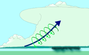
The gallery below shows the three stages of development of a mesocyclone and a view of the storm relative motion on radar of a mesocyclone-producing tornado overGreensburg, Kansason 4 May 2007. The storm was in the process of producingan EF5 tornadoat the time of the image.
-
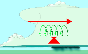 Wind shear (red) sets air spinning (green).
 -
 The updraft (blue) 'tips' the spinning air upright.
 -
 The updraft then starts rotating.
 -
 Radar view of a mesocyclone. Note that at the time of this image, anEF5 tornadowas currently on the ground.


Identification[edit]
The most reliable way to detect a mesocyclone is byDopplerweather radar. Nearby high values of opposite sign within velocity data are how they are detected.[4]Mesocyclones are most often located in the right-rear flank of supercell thunderstorms and when embedded within squall lines (whereas mesovortices most often form in the front flank of squall lines), and may be distinguished by ahook echorotation signature on a weather radar map. Visual cues such as a rotatingwall cloudor tornado may also hint at the presence of a mesocyclone. This is why the term has entered into wider usage in connection with rotating features in severe storms.
-
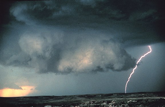 Mesocyclones are sometimes visually identifiable by a rotating wall cloud like the one in this thunderstorm over Texas.
 -
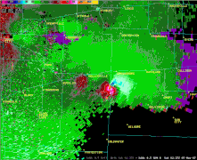
 Mesocyclone detection algorithmoutput on tornadic cells in Northern Michigan on July 3, 1999.


Tornado formation[edit]

Tornado formation is not completely understood, but often occurs in one of two ways.[5][6]
In the first method, two conditions must be satisfied. First, a horizontal spinning effect must form on the Earth's surface. This usually originates in sudden changes in wind direction or speed, known as wind shear.[7]Second, a cumulonimbus cloud, or occasionally a cumulus cloud, must be present.[7]
During a thunderstorm, updrafts are occasionally powerful enough to lift the horizontal spinning row of air upwards, turning it into a vertical air column. This vertical air column then becomes the basic structure for the tornado. Tornadoes that form in this way are often weak and generally last less than 10 minutes.[7]
The second method occurs during a supercell thunderstorm, in updrafts within the storm. When winds intensify, the force released can cause the updrafts to rotate. This rotating updraft is known as a mesocyclone.[8]
For a tornado to form in this manner, arear-flank downdraftenters the center of the mesocyclone from the back. Cold air, being denser than warm air, is able to penetrate the updraft. The combination of the updraft and downdraft completes the development of a tornado. Tornadoes that form in this method are often violent and can last over an hour.[7]
Mesoscale convective vortex[edit]
Amesoscale convective vortex(MCV), also known as a mesoscale vorticity center or Neddy eddy,[9]is a mesocyclone within amesoscale convective system(MCS) that pulls winds into a circling pattern, or vortex, at the mid levels of thetroposphereand is normally associated with anticyclonic outflow aloft, with a region of aeronautically troublesomewind shearbetween the upper and lower air. With a core only 30 to 60 miles (48 to 97 km) wide and 1 to 3 miles (1.6 to 4.8 km) deep, an MCV is often overlooked in standardweather maps.MCVs can persist for up to two days after its parent mesoscale convective system has dissipated.[9]
The orphaned MCV can become the seed of the next thunderstorm outbreak. An MCV that moves into tropical waters, such as the Gulf of Mexico, can serve as the nucleus for atropical cyclone.An example of this wasHurricane Barryin2019.MCVs can produce very large wind storms; sometimes winds can reach over 100 miles per hour (160 km/h). TheMay 2009 Southern Midwest Derechowas an extreme progressivederechoand mesoscale convective vortex event that struck southeastern Kansas, southern Missouri, and southwestern Illinois on 8 May 2009.
References[edit]
- ^ "Mesocyclone".Glossary of Terms. U.S.National Weather Service.Archivedfrom the original on 2019-09-03.Retrieved2019-10-17.
- ^ "Mesocyclone".amsglossary.allenpress.com.Glossary of Meteorology.American Meteorological Society.June 2000. Archived fromthe originalon 2006-07-09.Retrieved2006-12-07.
- ^ "Vertical Wind Shear".Meteorology guides.University of Illinois.Archived fromthe originalon 2006-11-08.Retrieved2006-10-21.
- ^ "Mesocyclone signature".amsglossary.allenpress.com.Glossary of Meteorology.American Meteorological Society.June 2000. Archived fromthe originalon 2011-05-14.Retrieved2010-02-01.
- ^ "Severe Weather 101: Tornado Basics".NOAA National Severe Storms Laboratory.National Oceanic and Atmospheric Administration.Archivedfrom the original on August 31, 2018.RetrievedOctober 2,2018.
- ^ Edwards, Roger (19 April 2018)."The Online Tornado FAQ".NOAA Storm Prediction Center.National Oceanographic and Atmospheric Administration.Archivedfrom the original on March 26, 2018.RetrievedOctober 2,2018.
- ^abcd "tornadoes...Nature's Most Violent Storms".Preparedness Guide.National Oceanic and Atmospheric Administration.September 1992. Archived fromthe originalon 2008-06-24.Retrieved2008-08-03.
- ^ "Tornado Formation".Thinkquest.Oracle Corporation.October 2003. Archived fromthe originalon 2008-04-21.Retrieved2009-08-03.
- ^ab "08 July 1997 -- Mesoscale Convective Complex decays, revealing a Mesoscale Vorticity Center".Cooperative Institute for Meteorological Satellite Studies.University of Wisconsin-Madison.2004-01-22.Archivedfrom the original on 2010-06-09.Retrieved2010-02-01.
External links[edit]
- "Definition of 'mesocyclone'".glossary. U.S.National Weather Service.
