
Millwall Dock
| Millwall Dock | |
|---|---|
 Opening of new docks at Millwall in 1868 | |
| Location | London |
| Coordinates | 51°29′43.37″N0°0′58″W/ 51.4953806°N 0.01611°W |
| Built | 1802 |
| Built for | Built speculatively byJohn KelkandJohn Aird & Co. |
| Architect | Sir John Fowler |
 Location of Millwall Dock in London Borough of Tower Hamlets | |
Millwall Dockis adockatMillwall,London,England,located south ofCanary Wharfon theIsle of Dogs.
History
[edit]


The scheme was developed speculatively by a partnership ofJohn KelkandJohn Aird & Co.[1]The engineer responsible for designing the scheme wasSir John Fowler.[1]The construction was undertaken by Kelk and Aird and the dock was officially opened in March 1868.[1]After a slow start to the business and financial difficulties, Kelk and Aird surrendered control of the company to lawyers acting for the investors in December 1868.[1]In recognition of its settled status the business was renamed theMillwall Dock Companyin 1870.[1]
From 1897 to 1921, it was served by theMillwall Docks railway stationon theMillwall Extension Railway,with goods services continuing to the 1970s.[2]
In 1909 thePort of London Authority(PLA) took over the Millwall Dock, along with the other enclosed docks fromSt KatharinestoTilbury.[3]
From 1905Magnus Mowatworked as Engineer to the docks, being promoted to Director around 1912.[4]
With reorganisation by thePort of London Authorityin the 1920s, the northern end of the Inner Dock was connected to theWest India Docksby the Millwall Passage.[1]
The dock was used mainlyfor timberand grain, a trade which eventually moved down river to thePort of Tilburywith the construction of a major grain terminal in the 1960s. AMcDougall'sflour mill, the Wheatsheaf Mill (constructed in 1869), stood on the south side of the Outer Dock, but was demolished in about 1980. Nearby Sir John McDougall Gardens is named after one of the McDougall brothers,John McDougall,who was also a prominent local politician in Poplar.[5]
From the 1960s onwards, the Millwall Dock experienced a steady decline – as did all of London's other docks – as the shipping industry adoptedcontainerisation,which effectively moved traffic downstream toTilbury.It finally closed to commercial traffic along with the other Royal Docks in 1981.[6]
The West Ferry Printing Works, the largest newspaper print works in Western Europe, was built on the north side of Outer Dock between 1984 and 1986.[7]
The Docklands Sailing and Watersports Centre, located at the far West end of the dock where the dock previously connected to theThames,[8]was established by theLondon Docklands Development Corporationand the Sports Council at a cost of £1.2 million in 1989.[9]
While much of the area has been occupied by commercial office towers, Millwall Dock is also an area where several housing developments andapartment towershave been developed. During the 1980s the Clippers Quay housing estate was built around the old dry dock[10]while the Mill Quay housing development was built on the site of the old Wheatsheaf Mill.[11]
The dock was a location for boat stunts in the 1999James BondfilmThe World Is Not Enough.[12]
Layout
[edit]Thedockis L-shaped, with an 'Outer Dock' running east–west, and an 'Inner Dock' running north from the eastern end. It originally contained around 36 acres (14 hectares) of water and had a 200-acre (81 hectare) estate. The western end of the Outer Dock was originally connected to the Thames atMillwallby an 80 ft (24 m) wide channel. The spoil from the docks formed the area of wasteland known as theMudchute.A graving dock for ship repairs was constructed at the south-east corner of the Outer Dock (one of 6 originally planned), and later lengthened to 555 ft (169 m).[1]
Gallery
[edit]-
 Millwall Dock and Glengall Bridge, June 2011
 -
 Millwall Outer Dock, September 2013
 -
 Millwall Inner Dock, September 2013
 -
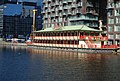 Floating restaurant, Millwall Dock, August 2013
 -
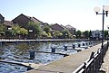 Side dock, Millwall Docks, August 2013
 -
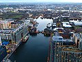 Looking south along Millwall Inner Dock, February 2014


References
[edit]- ^abcdefg'The Millwall Docks: The docks', in Survey of London: Volumes 43 and 44, Poplar, Blackwall and Isle of Dogs, ed. Hermione Hobhouse (London, 1994), pp. 353-356. British History Online URL:http://www.british-history.ac.uk/survey-london/vols43-4/pp353-356accessed 30 November 2019.
- ^"Disused Stations: Millwall Docks Station".
- ^"The Port of London".The Times.No. 38921. 31 March 1909. p. 10.Retrieved3 August2019.
- ^"Magnus Mowat".Graces Guide.Retrieved30 November2019.
- ^"Sir John McDougall Gardens".London Gardens Trust.Retrieved16 July2016.
- ^"History".London's Royal Docks.Retrieved30 November2019.
- ^Times Online,15 February 2004,Desmond's double whammy,says "Westferry is the biggest printing works in western Europe."
- ^"Docklands Sailing and Watersports Centre".www.timeout.com.Time Out. 30 April 2005.Retrieved3 December2013.
- ^Hyde, John (27 August 2008)."Beijing success brings boost to sailing centre".London: www.edp24.co.uk. Archived fromthe originalon 12 December 2013.Retrieved3 December2013.
- ^"Clippers Quay housing estate".Isle of Dogs Life.Retrieved30 November2019.
- ^"Beyond Canary Wharf – Visiting the Isle of Dogs' quieter corners".Past in the Present. 6 October 2016.Retrieved30 November2019.
- ^"The World Is Not Enough".Find that location.Retrieved30 November2019.
Other sources
[edit]- "'The Millwall Docks: The docks'".Survey Survey of London: volumes 43 and 44: Poplar, Blackwall and Isle of Dogs (1994), pp. 353-356.English Heritage.Retrieved17 October2007.
- 'Dockland: An illustrated historical survey of life and work in east London', NELP/GLC, 1983,ISBN0-7168-1611-3