
Molniya orbit


AMolniya orbit(Russian:Молния,IPA:[ˈmolnʲɪjə],"Lightning" ) is a type of satelliteorbitdesigned to provide communications andremote sensingcoverage over highlatitudes.It is ahighly elliptical orbitwith aninclinationof 63.4degrees,anargument of perigeeof 270 degrees, and anorbital periodof approximately half asidereal day.[1]The name comes from theMolniyasatellites, a series ofSoviet/Russiancivilian and militarycommunications satelliteswhich have used this type of orbit since the mid-1960s.
The Molniya orbit has a long dwell time over thehemisphereof interest, while moving very quickly over the other. In practice, this places it over eitherRussiaorCanadafor the majority of its orbit, providing a highangle of viewto communications and monitoring satellites covering these high-latitude areas.Geostationary orbits,which are necessarily inclined over theequator,can only view these regions from a low angle, hampering performance. In practice, a satellite in a Molniya orbit serves the same purpose for high latitudes as a geostationary satellite does for equatorial regions, except that multiple satellites are required for continuous coverage.[2]
Satellites placed in Molniya orbits have been used for television broadcasting, telecommunications, military communications, relaying, weather monitoring,early warning systemsand some classified purposes.
History[edit]
The Molniya orbit was discovered by Soviet scientists in the 1960s as a high-latitudecommunications alternative togeostationary orbits,which require large launch energies to achieve a highperigeeand tochange inclinationto orbit over the equator (especially when launched from Russian latitudes). As a result,OKB-1sought a less energy-demanding orbit.[3]Studies found that this could be achieved using a highly elliptical orbit with anapogeeover Russian territory.[4]The orbit's name refers to the "lightning" speed with which the satellite passes through the perigee.[5]
The first use of the Molniya orbit was by thecommunications satelliteseriesof the same name.After two launch failures, and one satellite failure in 1964, the first successful satellite to use this orbit, Molniya 1-1, launched on 23 April 1965.[4][6]The early Molniya-1 satellites were used for civilian television, telecommunication and long-range military communications, but they were also fitted with cameras used for weather monitoring, and possibly for assessing clear areas forZenit spy satellites.[3][7]The original Molniya satellites had a lifespan of approximately 1.5 years, as their orbits were disrupted byperturbations,and they had to be constantly replaced.[1]
The succeeding series, the Molniya-2, provided both military and civilian broadcasting and was used to create theOrbitatelevision network,spanning the Soviet Union. These were in turn replaced by the Molniya-3 design.[4]A satellite called Mayak was designed to supplement and replace the Molniya satellites in 1997, but the project was cancelled,[8]and the Molniya-3 was replaced by theMeridiansatellites, the first of which launched in 2006.[9]The SovietUS-Kearly warning satellites,which watch for American rocket launches, were launched in Molniya orbits from 1967, as part of theOkosystem.[10][11][12]
From 1971, the AmericanJumpseatandTrumpetmilitary satellites were launched into Molniya orbits (and possibly used to intercept Soviet communications from the Molniya satellites). Detailed information about both projects remains classified as of 2019[update].[13]This was followed by the AmericanSDSconstellation, which operates with a mixture of Molniya and geostationary orbits. These satellites are used to relay signals from lower flying satellites back to ground stations in the United States and have been active in some capacity since 1976.[14]A Russian satellite constellation called Tyulpan was designed in 1994 to support communications at high latitudes, but it did not progress past the planning phase.[8]
In 2015 and 2017 Russia launched twoTundrasatellites into a Molniya orbit, despite their name, as part of itsEKSearly warning system.[15][16][17]


Uses[edit]

Much of the area of the formerSoviet Union,andRussiain particular, is located at high northern latitudes. To broadcast to these latitudes from a geostationary orbit (above the Earth'sequator) requires considerable power due to the lowelevation angles,and the extra distance and atmospheric attenuation that comes with it. Sites located above 81° latitude are unable to view geostationary satellites at all, and as a rule of thumb, elevation angles of less than 10° can cause problems, depending on the communications frequency.[2]: 499 [18]
A satellite in a Molniya orbit is better suited to communications in these regions, because it looks more directly down on them during large portions of its orbit. With an apogee altitude as high as 40,000 kilometres (25,000 mi) and an apogee sub-satellite point of 63.4 degrees north, it spends a considerable portion of its orbit with excellent visibility in the northern hemisphere, from Russia as well as from northern Europe, Greenland and Canada.[2]
While satellites in Molniya orbits require considerably less launch energy than those in geostationary orbits (especially launching from high latitudes),[4]their ground stations need steerable antennas to track the spacecraft, links must be switched between satellites in a constellation and range changes cause variations in signal amplitude. Additionally, there is a greater need forstation-keeping,[19][20][21]and the spacecraft will pass through theVan Allen radiation beltfour times per day.[22]
Southern hemisphere proposals[edit]
Similar orbits with an argument of perigee of 90° could allow high-latitude coverage in the southern hemisphere. A proposed constellation, theAntarctic Broadband Program,would have used satellites in an inverted Molniya orbit to providebroadband internet serviceto facilities inAntarctica.[23][24]Initially funded by the now defunctAustralian Space Research Program,it did not progress beyond initial development.[25][26]
Molniya constellations[edit]
Permanent high-latitude coverage of a large area of Earth (like the whole of Russia, where the southern parts are about 45°N) requires a constellation of at least three spacecraft in Molniya orbits. If three spacecraft are used, then each spacecraft will be active for a period of eight hours per orbit, centered around apogee,[2]as illustrated in figure 4. Figure 5 shows the satellite's field of view around the apogee.
The Earth completes half a rotation in twelve hours, so the apogees of successive Molniya orbits will alternate between one half of the northern hemisphere and the other. For the original Molniya orbit, the apogees were placed over Russia and North America, but by changing theright ascension of the ascending nodethis can be varied.[19]The coverage from a satellite in a Molniya orbit over Russia is shown in figures 6 to 8, and over North America in figures 9 to 11.
The orbits of the three spacecraft should then have the same orbital parameters, but different right ascensions of the ascending nodes, with their passes over the apogees separated by 7.97 hours.[2][27]Since each satellite has an operational period of approximately eight hours, when one spacecraft travels four hours after its apogee passage (see figure 8 or figure 11), then the next satellite will enter its operational period, with the view of the earth shown in figure 6 (or figure 9), and the switch-over can take place. Note that the two spacecraft at the time of switch-over are separated by about 1,500 kilometres (930 mi), so that the ground stations only have to move their antennas a few degrees to acquire the new spacecraft.[28]
Diagrams[edit]
-
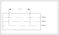 Figure 4: A constellation of three Molniya spacecraft providing service for the Northern hemisphere.Pis the orbital period. A green line corresponds to service for Asia and Europe with the visibility of figures 6–8. A red line corresponds to service for North America with the visibility of figures 9–11.
 -
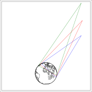 Figure 5: Illumination zones (at least 10° elevation) from a Molniya orbit. At apogee, the green illumination zone applies. At three hours before or after apogee, the red zone applies. At four hours before or after apogee, the blue zone applies. The plane of the figure is the longitudinal plane of apogee rotating with the Earth. In the eight-hour period centered at the apogee passage, the longitudinal plane is almost fixed, the longitude of the satellite varies by only ±2.7°. The views of the Earth from these three points are displayed in figures 6–11.
 -
 Figure 6: View of the Earth four hours before apogee from a Molniya orbit under the assumption that the longitude of the apogee is 90°E. The spacecraft is at an altitude of 24,043 km over the point 92.65°E 47.04°N.
 -
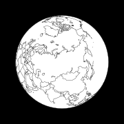 Figure 7: View of the Earth from the apogee of a Molniya orbit under the assumption that the longitude of the apogee is 90°E. The spacecraft is at an altitude of 39,867 km over the point 90°E 63.43°N.
 -
 Figure 8: View of the Earth four hours after apogee from a Molniya orbit under the assumption that the longitude of the apogee is 90° E. The spacecraft is at an altitude of 24,043 km over the point 87.35°E 47.04°N
 -
 Figure 9: View of the Earth four hours before apogee from a Molniya orbit under the assumption that the longitude of the apogee is 90°W. The spacecraft is at an altitude of 24,043 km over the point 87.35°W 47.04°N.
 -
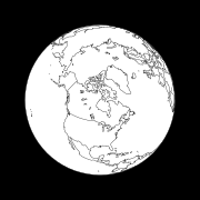 Figure 10: View of the Earth from the apogee of a Molniya orbit under the assumption that the longitude of the apogee is 90°W. The spacecraft is at an altitude of 39,867 km over the point 90°W 63.43°N.
 -
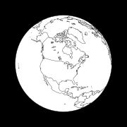 Figure 11: View of the Earth 4 hours after apogee from a Molniya orbit under the assumption that the longitude of the apogee is 90°W. The spacecraft is at an altitude of 24,043 km over the point 92.65°W 47.04°N.


Properties[edit]
A typical Molniya orbit has the following properties:
- Argument of perigee: 270°
- Inclination: 63.4°[20]
- Period: 718 minutes[1]
- Eccentricity: 0.74
- Semi-major axis:26,600 km (16,500 mi)
Argument of perigee[edit]
The argument of perigee is set at 270°, causing the satellite to experience apogee at the most northerly point of its orbit. For any future applications over the southern hemisphere, it would instead be set at 90°.[24]
Orbital inclination[edit]
In general, theoblatenessof the Earthperturbstheargument of perigee(), so that it gradually changes with time. If we only consider the first-order coefficient,the perigee will change according to equation1,unless it is constantly corrected with station-keeping thruster burns.


| (1) |

whereis the orbital inclination,is the eccentricity,is mean motion in degrees per day,is the perturbing factor,is the radius of the earth,is the semimajor axis, andis in degrees per day.


To avoid this expenditure of fuel, the Molniya orbit uses an inclination of 63.4°, for which the factoris zero, so that there is no change in the position of perigee over time.[20][19]: 143 An orbit designed in this manner is called afrozen orbit.

Orbital period[edit]
To ensure the geometry relative to the ground stations repeats every 24 hours, theperiodshould be about half asidereal day,keeping the longitudes of the apogees constant.
However, theoblatenessof the Earth also perturbs the right ascension of theascending node(), changing thenodal periodand causing theground trackto drift over time at the rate shown in equation2.

| (2) |

whereis in degrees per day.[19]: 143

Since the inclination of a Molniya orbit is fixed (as above), this perturbation isdegrees per day. To compensate, the orbital period is adjusted so that the longitude of the apogee changes enough to cancel out this effect.[20]

Eccentricity[edit]
The eccentricity of the orbit is based on the differences in altitudes of its apogee and perigee. To maximise the amount of time that the satellite spends over the apogee, the eccentricity should be setas high as possible.However, the perigee needs to be high enough to keep the satellite substantially above theatmosphereto minimize drag (~600km), and the orbital period needs to be kept to approximately half a sidereal day (as above). These two factors constrain the eccentricity, which becomes approximately 0.737.[20]
Semi-major axis[edit]
The exact height of a satellite in a Molniya orbit varies between missions, but a typical orbit will have a perigee altitude of approximately 600 kilometres (370 mi) and an apogee altitude of 39,700 kilometres (24,700 mi), for a semi-major axis of 26,600 kilometres (16,500 mi).[20]
Modelling[edit]
To track satellites using Molniya orbits, scientists use the SDP4simplified perturbations model,which calculates the location of a satellite based on orbital shape, drag, radiation, gravitation effects from the sun and moon, and earth resonance terms.[29]
See also[edit]
References[edit]
- ^abcKolyuka, Yu. F.; Ivanov, N.M.; Afanasieva, T.I.; Gridchina, T.A. (28 September 2009).Examination of the Lifetime, Evolution and Re-Entry Features for the "Molniya" Type Orbits(PDF).21st International Symposium of Space Flight Dynamics. Toulouse, France: Mission Control Center 4, Korolev, Moscow. p. 2.Retrieved22 May2018.
- ^abcdeIlčev, Stojče Dimov (2017).Global Satellite Meteorological Observation (GSMO) Theory.Vol. 1. Springer International Publishing. p. 57.ISBN978-3-319-67119-2.Retrieved16 April2019.
- ^abHistory Committee of the American Astronautical Society (23 August 2010). Johnson, Stephen B. (ed.).Space Exploration and Humanity: A Historical Encyclopedia.Vol. 1. Greenwood Publishing Group. p. 416.ISBN978-1-85109-514-8.Retrieved17 April2019.
- ^abcdMartin, Donald H. (2000).Communication Satellites(4 ed.).American Institute of Aeronautics and Astronautics.pp. 215–232.ISBN978-1-884989-09-4.Retrieved17 April2019.
- ^Capderou, Michel (23 April 2014).Handbook of Satellite Orbits: From Kepler to GPS.Springer Science & Business. p. 393.Bibcode:2014hso..book.....C.ISBN978-3-319-03416-4.Retrieved16 April2019.
- ^Preliminary Analysis of the First Successful Soviet Communications Satellite(PDF)(Report).CIA:Office of Scientific Intelligence. 12 December 2003. p. 3. Archived fromthe original(PDF)on January 23, 2017.Retrieved16 April2016.
- ^Hendrickx, Bart (2004)."A History of Soviet/Russian Meteorological Satellites"(PDF).Journal of the British Interplanetary Society.57 (Suppl. 1): 66. Archived fromthe original(PDF)on 2018-03-27.Retrieved2018-03-27.
- ^abHeyman, Jos (December 2015). Heyman, Jos (ed.).Cancelled projects: Russian comsats(PDF)(Report). Vol. 41. IAC 2017: Tiros Space Information News Bulletin. p. 4. Archived fromthe original(PDF)on 5 March 2019.Retrieved16 April2019.
{{cite report}}:CS1 maint: location (link) - ^Graham, William (4 May 2011)."Soyuz 2-1a launches with Russian Meridian 4 military satellite".NASASpaceflight.com.Retrieved16 April2019.
- ^Forden, Geoffrey (May 3, 2001)."Reducing a Common Danger: Improving Russia's Early-Warning System"(PDF).Cato Policy Analysis No. 399:5.Retrieved16 April2019.
- ^Podvig, Pavel (2002)."History and the Current Status of the Russian Early-Warning System"(PDF).Science and Global Security.10(1): 21–60.Bibcode:2002S&GS...10...21P.CiteSeerX10.1.1.692.6127.doi:10.1080/08929880212328.ISSN0892-9882.S2CID122901563.Archived fromthe original(PDF)on 2012-03-15.
- ^"Russia blinded by loss of missile detection satellite".Moscow Times. 26 June 2014.Retrieved16 April2019.
- ^Graham, William (23 September 2017)."Atlas V launches NROL-42 spy satellite".NASASpaceflight.com.Retrieved16 April2019.
- ^Richelson, Jeffrey T (2002).The Wizards of Langley. Inside the CIA's Directorate of Science and Technology.Boulder:Westview Press.ISBN978-0-8133-4059-3.Retrieved17 April2019.
- ^Tomasz Nowakowski (November 17, 2015)."Russian Soyuz-2.1b rocket successfully launches Tundra satellite".Spaceflight Insider.
- ^Curt Godwin (May 25, 2017)."Soyuz rocket successfully delivers EKS-2 early-warning satellite to rare orbit".Spaceflight Insider.
- ^Clark, Stephen (25 May 2017)."Russia sends military satellite into orbit for missile warnings – Spaceflight Now".
- ^Soler, Tomás; Eisemann, David W. (August 1994)."Determination of Look Angles To Geostationary Communication Satellites"(PDF).Journal of Surveying Engineering.120(3): 123.doi:10.1061/(ASCE)0733-9453(1994)120:3(115).ISSN0733-9453.Retrieved16 April2019.
- ^abcdWertz, James Richard; Larson, Wiley J. (1999). Larson, Wiley J.; Wertz, James R. (eds.).Space Mission Analysis and Design.Microcosm Press and Kluwer Academic Publishers.Bibcode:1999smad.book.....W.ISBN1-881883-10-8.
- ^abcdefKidder, Stanley Q.; Vonder Haar, Thomas H. (18 August 1989)."On the Use of Satellites in Molniya Orbits of Meteorological Observation of Middle and High Latitudes".Journal of Atmospheric and Oceanic Technology.7(3): 517.Bibcode:1990JAtOT...7..517K.doi:10.1175/1520-0426(1990)007<0517:OTUOSI>2.0.CO;2.
- ^King-Hele, D. G. (January 1975)."The Orbital Lifetime of Molniya Satellites".Journal of the British Interplanetary Society.28:783–796.Bibcode:1975JBIS...28..783K.
- ^van der Ha, Jozef C., ed. (November 1997).Mission Design & Implementation of Satellite Constellations: Proceedings of an International Workshop held in Toulouse, France.Springer-Science. p. 67.ISBN9401061378.Retrieved16 April2019.
- ^"Antarctic Broadband program".rsaa.anu.edu.au.Australian National University.Retrieved12 April2019.
- ^abBonin, Grant; Zee, Robert; Brett, Michael; King, Jan; Faber, Daniel (October 2012).Antarctic Broadband: Fast Internet for the Bottom of the Earth.IAC 2012.Retrieved12 April2019.
- ^Bird, Cameron, ed. (17 November 2015).Final evaluation of the Australian Space Research Program(PDF)(Report). Department of Industry, Innovation and Science. Archived fromthe original(PDF)on 5 March 2019.Retrieved12 April2019.
- ^Dempster, Andrew (15 May 2018)."As the details emerge on Australia's new space agency, we (might) finally have lift-off".The Conversation.Retrieved12 April2019.
- ^Kidder, Stanley Q.; Vonder Haar, Thomas H. (June 1990)."On the Use of Satellites in Molniya Orbits for Meteorological Observation of Middle and High Latitudes".Journal of Atmospheric and Oceanic Technology.7(3): 519.Bibcode:1990JAtOT...7..517K.doi:10.1175/1520-0426(1990)007<0517:OTUOSI>2.0.CO;2.
- ^Sturdivant, R. L.; Chon, E. K. P. (2016)."Systems Engineering of a Terabit Elliptic Orbit Satellite and Phased Array Ground Station for IoT Connectivity and Consumer Internet Access".IEEE Access.4:9947.doi:10.1109/ACCESS.2016.2608929.
- ^Hoots, Felix R.; Roehrich, Ronald L. (31 December 1988).Models for Propagation of NORAD Element Sets(PDF)(Report). United States Department of Defense Spacetrack Report.Retrieved16 June2010.
External links[edit]
Gravitationalorbits | |||||||||
|---|---|---|---|---|---|---|---|---|---|
| Types |
| ||||||||
| Parameters |
| ||||||||
| Maneuvers | |||||||||
| Orbital mechanics |
| ||||||||