
Mosby, Montana
Mosby, Montana | |
|---|---|
 Mosby  Mosby | |
| Coordinates:46°59′32″N107°53′1″W/ 46.99222°N 107.88361°W | |
| Country | United States |
| State | Montana |
| County | Garfield |
| Elevation | 2,513 ft (766 m) |
| Time zone | UTC-7(Mountain (MST)) |
| • Summer (DST) | UTC-6(MDT) |
| ZIP codes | 59058 |
| GNISfeature ID | 774406 |
Mosby(alsoHalf-Breed Crossing) is a tinyunincorporated communityin southwesternGarfield County,Montana,United States. It lies alongHighway 200southwest of the town ofSand Springs,its nearest neighboring settlement. Its elevation is 2,513 feet (766 m) above sea level.[1]Although Mosby has had no post office since 2015, it still has a separateZIP codeof 59058.[2]As of 2015, there is an RV park where the gas station was; and there is a church, but no other businesses or services.
TheMosby Dome Cat Creek Oil Fieldis in this area.
History[edit]
Originally known as Baldwin, this town takes its name from the area’s first settler, who arrived in 1891.[3] Mosby had a post office that opened on June 29, 1904, was moved on February 18, 1983, and closed on July 30, 2015[4] There was a gas station and repair shop open from 1950 to 1983.
Climate[edit]
According to theKöppen Climate Classificationsystem, Mosby has asemi-arid climate,abbreviated "BSk" on climate maps.[5]
References[edit]
- ^U.S. Geological Survey Geographic Names Information System: Mosby, Montana
- ^Zip Code Lookup
- ^"Mosby".Montana Place Names Companion.Montana Historical Society.RetrievedApril 7,2021.
- ^U.S. Geological Survey Geographic Names Information System: Mosby Post Office
- ^Climate Summary for Mosby, Montana
Municipalities and communities ofGarfield County, Montana,United States | ||
|---|---|---|
| Town | 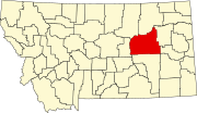 | |
| Unincorporated communities | ||
| International | |
|---|---|
| National | |
ThisGarfield County,Montanastate location article is astub.You can help Wikipedia byexpanding it. |