
Mount Akagi
| Mount Akagi | |
|---|---|
| Xích thành sơn | |
 | |
| Highest point | |
| Elevation | 1,828 m (5,997 ft)[1] |
| Listing | |
| Coordinates | 36°33′26″N139°11′47″E/ 36.55722°N 139.19639°E[1] |
| Naming | |
| English translation | Red Castle Mountain |
| Language of name | Japanese |
| Geography | |
 Mount Akagi | |
| Country | Japan |
| Prefecture | Gunma |
| Geology | |
| Mountain type | Stratovolcano |
| Last eruption | Possibly 1251[1] |

Mount Akagi(Xích thành sơn,Akagi-yama,Red Castle)is a stratovolcano inGunma Prefecture,Japan.
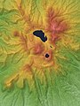
The broad, low dominantlyandesiticstratovolcanorises above the northern end of the Kanto Plain. It contains an elliptical, 3 km × 4 km (1.9 mi × 2.5 mi) summitcalderawith post-calderalava domesarranged along a NW–SE line. Lake Ono is located at the NE end of the caldera. An older stratovolcano was partially destroyed by edifice collapse, producing a debris-avalanche deposit along the south flank. A series of largeplinian eruptionsaccompanied growth of a second stratovolcano during thePleistocene.Construction of the central cone in the late-Pleistocene summit caldera began following the last of the plinian eruptions about 31,000 years ago. During historical time unusual activity was recorded on several occasions during the 9th century, but reported eruptions in 1251 and 1938 are considered uncertain.[1]
Mount Akagi, along withMount MyōgiandMount Haruna,is one of the "Three Mountains of Jōmō"(Thượng mao tam sơn),and the cold north winds which blow down from it are calledAkagi-oroshi(Xích thành おろし)orKarakkaze(Không っ phong).
TheAmagi-class battlecruiserAkagi,converted into an aircraft carrier during construction, was named after Mount Akagi and was the flagship for the strike force commanded by Vice AdmiralChuichi Nagumoin theattack on Pearl Harbor.The carrier was later sunk in theBattle of Midway.
Religion
[edit]Mount Akagi is an object of worship in this region. On Ōno Lake, there isAkagi Shrine.
Access
[edit]The upper portions of the prefectural road Route 4 approach the top of Mount Akagi.Kanetsu Kotsu Buscomes toAkagi Visitor CenterfromMaebashi StationorFujimi OnsenBus Stop.
Climbing routes
[edit]To the top of Mount Kurobi, the highest point of this mountain, it takes about three hours from the Akagi Hiroba Bus Stop.
In popular culture
[edit]The sixthZatoichifilm,Zatoichi and the Chest of Gold,this mountain is the destination of Ichi as he searches for the brigand Chuji.
Mount Akagi is mentioned in the street racing manga and anime seriesInitial D.The portions of Gunma Route 4 [GPS Coordinates 36°32'31.6 "N 139°09'59.5" E] on Mount Akagi are featured in numerousInitial Depisodes. It is the home course of the racing team called the Akagi Redsuns
Mount Akagi is also featured in the street racing gameTokyo Xtreme Racer: Drift 2and the arcade/simulator gameAuto Modellista.[2]
According to unofficial sources, Mt. Moon from thePokémonfranchise is based on Mount Akagi.[3][4]
Gallery
[edit]-
 Mountaintop Area
 -
 View from Maebashi city
 -
 ESE side
 -
 Lake Ōno and Mount Jizo and Akagi Shrine in summer
 -
 Lake Ōno and Mount Jizo in winter
 -
 Kurobi Ōkami Shrine near the top of Mount Kurobi
 -
 Mount Kurobi from Akagi Hiroba Bus Stop


References
[edit]- ^abcd"Akagisan".Global Volcanism Program.Smithsonian Institution.Retrieved2010-03-19.
- ^Digital Displacement,http://www.digitaldisplacement.com/?p=2705Archived2012-03-27 at theWayback Machine
- ^"【ポケモン/ lữ hành 】ニビシティのモデルはどこ?".むらこたび. のポケモン nhật ký(in Japanese).Retrieved17 June2022.
- ^"ゲーム nội の địa danh のモデル nhất lãm".wiki.xn--rckteqa2e.com(in Japanese).Retrieved17 June2022.
External links
[edit]- Akagisan- Japan Meteorological Agency(in Japanese)
- "Akagisan: National catalogue of the active volcanoes in Japan"(PDF).- Japan Meteorological Agency
- Akagi San- Geological Survey of Japan
- Akagisan: Global Volcanism Program- Smithsonian Institution
| Hokkaidō | |||||||||
|---|---|---|---|---|---|---|---|---|---|
| Tōhoku region Jōshinetsu region |
| ||||||||
| Kantō region | |||||||||
| Chūbu region |
| ||||||||
| Western Japan | |||||||||
| |||||||||
| International | |
|---|---|
| National | |
| Geographic | |