
Mud (village)
Mud
Mudh, Muth | |
|---|---|
Village | |
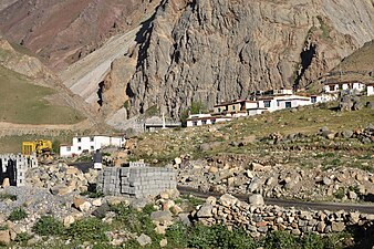
 Mud village above Pin river, Jun '18 | |
 Mud | |
| Coordinates:31°57′33″N78°01′57″E/ 31.95917°N 78.03250°E | |
| Country | |
| State | Himachal Pradesh |
| District | Lahaul and Spiti |
| Tehsil | Spiti |
| Government | |
| • Type | Panchayat |
| • Body | Gram Panchayat, Sagnam |
| Area | |
| • Total | 0.776 km2(0.300 sq mi) |
| Population (2011) | |
| • Total | 213 |
| • Density | 270/km2(710/sq mi) |
| Time zone | UTC+5:30(IST) |
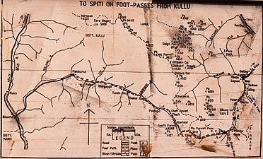
Mud(also known asMudhandMuth) is a small village in the cold desert region ofSpitiinHimachal Pradesh,India.Located at an altitude of 3,810 m (12,500 ft) on the left bank of the Pin River, a right bank tributary of theSpiti River,the village is nestled at the base of the Parbati range that towers almost vertically 1,600 m (5,200 ft) above. Mud is near the boundary of thePin Valley National Parkand is a convenient base for treks in the park, and to the neighbouring districts of Kullu and Kinnaur. It is the last village on the Spiti side of the Pin Parbati trek toKulluand the Pin Bhaba trek toKinnaur.
Mud became famous among geologists in the 1860s when the Moravian geologistFerdinand Stoliczkadiscovered a major geological formation in the Himalayas that he named theMuth Succession,after Mud. This spurred many geologists to do fieldwork in the Pin Valley. TheMuth Formation,as it is now known, has a thickness of 258–300 m (846–984 ft). Consisting of whitequartz arenite,it is resistant to weathering and readily visible.[1]
History
[edit]
Mud was mentioned byFerdinand Stoliczkain a paper in theMemoirs of the Geological Survey of India,1866. Stoliczka was a Moravian paleontologist who joined the Geological Survey of India in 1862. He made Mud the base for his fieldwork on the geology of theWestern Himalayasand named an important geological rock layer stretching fromKashmirthroughSpititoNepalin the Western Himalayas, calling it the Mudh (Mud) Series.[2]This remote village at the upper end of thePin River Valley,surrounded by inhospitable mountains, thus attained prominence.
Spurred by Stoliczka's publication, other geologists visited Mud for fieldwork during the remainder of the 19th century. These included C. L. Griesbach (1880s), C. Diener (1890s), and H. H. Hayden (1899). Their research and publications confirmed the prominence of Mud in geology. Hayden renamed the Mudh Series to the Mudh Formation, a name that is still in use today.[3]G. Fuchs wrote: "The pioneering work by Stoliczka, Griesbach, Von Krafft, Dlener, and Hayden has made Spiti famous as a classical geological area of the Himalaya, particularly of the Tethys or Tibetan Zone."[1]
After a gap of many decades after Hayden's 1899 visit, in July – September 1978, an Indo-Austrian expedition led by G. Fuchs (Geological Survey of Austria) and D.K. Bhatt (Geological Survey of India) did fieldwork on the Mudh Formation in Mud and nearby places.[1]In 1997–98, Erich Draganits, a PhD student at theUniversity of Viennadid his fieldwork in Mud.[4]Subsequently, Indian geologists Parcha and Pandey from theWadia Institute of Himalayan Geology,Dehradun,visited in about 2011.[5]These recent studies succeeded in firmly establishing the origins and age of the Mudh Formation.
Geography
[edit]
Mud is located on the left bank of the Pin River, which is a right bank tributary of theSpiti River.The village is at the base of the towering Pin Parbati range that separates Spiti fromKullu district.It is the first inhabited place encountered by travelers coming fromKullu valleyvia the Pin Parbati Pass and fromKinnaurvia thePin Bhaba Pass.[6][7]The village is at a distance of 48 km (30 mi) fromKaza, Spiti.This is the route onNH-505fromManali.[8]FromTabo,en route onNH-505fromShimla,the distance is 65 km (40 mi).[9]The village covers an area of 77.6 ha (192 acres).[10]: 252
Climate
[edit]Spiti is a cold desert region with an annual rainfall of about 17 cm (6.7 in).[11] The weather is mild from April to October. From May to June, the temperatures range between 15–20 °C (59–68 °F). During the winter, the temperature may drop to −20 °C (−4 °F).[12]
Geology
[edit]Spitiis a high-altitude semi-desert. Over millennia, theSpiti Riverand its tributaries such as the Pin River, have cut deep gorges in the sedimentary strata uplifted during the formation of theHimalayas.With little rain or snow there is not much weathering of the steep valley sides. As vegetation is sparse, the rock strata in the steep cliffs are easily visible to the geologist, without excavation or drilling. These favourable conditions for observation attracted geologists to the Pin Valley starting withStoliczkain the 1860s. In the mountain sides near Mud, Stoliczka identified a number of layers or successions, one of which he named as theMuth succession.[2]This was later renamed as theMuth Systemby Hayden (1908) and as theMuth Formationby Srikantia (1981).[5]Other formations, visible near Mud, that occur above and below the Muth Formation are given in the table.[1][4]
| Formation | Geologic Era(mya) | Dated Fossils
(mya) |
|---|---|---|
| Kuling | Permian(299–252) | |
| Lipak | Late Devonian(387–359) | 387.7–382.7[1] |
| Muth | Early Devonian(419–393) | |
| Pin | Late Ordovician–Late Silurian | 433–423[1] |
| Thango | Early – Late Ordovician | |
| Haimanta | Late Proterozoic–Middle Cambrian |
The Muth Formation is readily observed in the Farakah Section, north-west of Mud village.[5]It is also very well exposed inZanskar,Lahaul,Spiti,Kinnaur,Garhwaland in theNepal Himalayas.It consists mostly of hard, white or slightly greenishquartz arenite258 to 300 m (846 to 984 ft) thick, with an 11 to 15 m (36 to 49 ft) thick layer ofdolomitenear the top. The white colour and resistance to weathering make it easy to observe.[1]
It exhibitscurrent bedding,ripple marksand burrows. These indicate that it originated from coastal sediments deposited in a wave-dominatedbarrier islandsystem in theTethys Sea.The sedimentary rock was transformed bymetamorphosisinto quartz during thetectoniccollision.[4]
The quartz arenite rock strata were formed under high temperatures and/or pressures. Hence, body fossils did not survive. Onlyinchnofossils(i.e. fossil traces such as burrows and tracks), are found. The neighbouring formations, Pin (lower, i.e. older) and Lipak (upper, i.e. younger), have body fossils that are accurately dated. The trace fossils in the Mudh Formation and the dates of the neighbouring formations have been used to approximately date the Mudh Formation to theEarly Devonian(419 – 393 mya).[1]
Demographics and amenities
[edit]
The population as of the 2011 Census was 213 (females: 113 (53%), males: 100 (47%)), with 45 households.[10][13]: 98 The literacy rate among females is 54% and among males is 81%. The majority of the population are Scheduled Tribes comprising 96.2%, while Scheduled Castes comprise 1.88%.[13]: 99 The language spoken in Spiti isBhoti.[10]: 62
Mud is a village in the SagnamGram Panchayat.[14]A government primary and middle school caters to children of the village.[10]: 252 The village has a branch post office. The nearest full-service sub post office including international speed post is located at Sagnam, a distance of 14 km (8.7 mi).[15][16]
Places of interest
[edit]
Mud is a convenient base for visiting thePin Valley National Park.Trails from Mud head north and west to the National Park, west toKullu districtvia thePin Parbati Pass,and south toKinnaur districtvia thePin Bhaba Pass.
The Pin Valley is a cold desert with alpine pasture or dry alpine scrub forest. Located at a high altitude with the upper reaches being largely unexplored, the area is home to several endangered species including thesnow leopard.About 20 species of birds and animals are found in theNational Park,some of which may be seen in the Pin valley near Mud. These includeIbex,Chhumurthi horse,Bharal,Red fox,Marten,Weasel,Pika,Snow Cock,Bearded vulture,Chukor,Golden Eagle,Griffon,Yellow-billed Chough,Raven etc.[17]
Mud has two Buddhist nunneries, meditation caves and shelters. These belong to theNyingmapaschool, the oldest of the four major schools ofTibetan Buddhism.[18]These are located on the Killung Nala, a small stream that meets the Pin River at Mud.[7]
Mud is the last village on the trekking trails to theKullu valleyand toKinnaur district.Both routes start along the left bank of the Pin River. After about 12 km (7.5 mi) the trail reaches Chhochhden Camp at the confluence of 3 nallahs. The ruins of Lyungti Khar, a fort built by the Kullu Rajas, is nearby. One trail heads west towards thePin Parbati Pass(elev. 5,319 m (17,451 ft) and down the Parbati valley toManikaranandKullu.This trek usually takes 5 to 7 days.[7]
The other trail continues south from Chhochhden Camp to thePin Bhaba Pass(elev. 4,890 m (16,040 ft) and on to Kaphnu in Kinnaur, a total distance of 50 km (31 mi). Kaphnu is 18 km (11 mi) fromNH 5which runs along the Satluj River toShimla.This trek takes 4 to 5 days for the 50 km (31 mi) distance. Harish Kapadia reported that local people traveling to Shimla for business or studies would prefer the short trek over the Pir Bhaba Pass to the uncertain 254 km (158 mi) road journey via Tabo.[7][19]
Transport
[edit]During the summer, public buses and private vans ply regularly fromKazato Mikkim and Mud in the Pin valley. During the winter, buses do not ply to the Pin valley. Then, the approach to Mud is via private vehicle and foot from Attargo bridge offNH-505,a distance of 33 km (21 mi).[17][20]
In early 2022, theGovernment of Himachal Pradeshapproved construction of a new road connecting theSatluj Valley,Kinnaur Districtto theSpiti Valleyvia Mud. The new 72 km (45 mi) road will run from Kafnu (NH-5) in Kinnaur to Mud, connecting toNH-505near Atargu Bridge on theSpiti river.The new bypass will reduce the 460 km (290 mi) distance fromShimlatoKazaby 105 km (65 mi). This will open up thePin Valley National Park,Mud and theSpiti Valleyto tourism.[21]
Accommodation
[edit]There are a few home stays in Mud, the oldest being Tara House Home Stay.[22]
Gallery
[edit]-
 Road from Kaza entering Mud
 -
 Nyingma monastery, Mud
 -
 View down the Pin valley to Mud
 -
 Right bank of Pin river looking towards Mud, Jun '18
 -
 Hikers approach Mud on left bank of Pin
 -
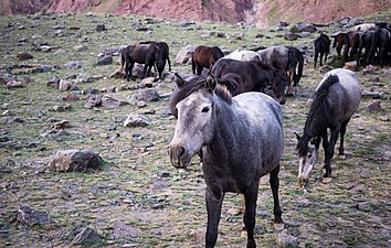 Chhumurthi horses near Mud
 -
 Sparse alpine vegetation, Jun '18
 -
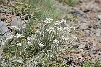 Sparse Alpine vegetation, Jun '18
 -
 Brandt's Mountain finch, Jun '18
 -
 Field of peas in Mud village, Jun '18
 -
 Trail from Mud to Kullu via the Pin Parbati Pass


See also
[edit]References
[edit]- ^abcdefghFuchs, G. (June 1982). "The Geology of the Pin valley in Spiti, H. P., India".Jahrbuch der Geologischen Bundesanstalt.124(2): 325–359.
- ^abStoliczka, F. (1866). "Geological Sections across the Himalayan Mountains from Wangtu Bridge on the River Sutlej to Sungdo on the Indus, with an account of the formations in Spiti, accompanied by a revision of all known fossils from that district".Memoirs of the Geological Survey of India.V.Geological Survey of India:1–154.
- ^Hayden, H.H. (1904). "The Geology of Spiti, with Parts of Bashahr and Rupshu".Memoirs of the Geological Survey of India.XXXVI, Part I (I). Calcutta:Geological Survey of India:1–129.
- ^abcDraganits, Erich; Braddy, Simon J.; Briggs, Derek E.G. (April 2001)."A Gondwanan Coastal Arthropod Ichnofauna from the Muth Formation (Lower Devonian, Northern India): Paleoenvironment and Tracemaker Behavior".PALAIOS.16(2).Society for Sedimentary Geology:126–147.Bibcode:2001Palai..16..126D.doi:10.1669/0883-1351(2001)016<0126:AGCAIF>2.0.CO;2.JSTOR3515525.S2CID54836908.Archivedfrom the original on 3 July 2022.Retrieved3 July2022.
- ^abcParcha, S.K.; Pandey, Shivani (September 2011). "Devonian Ichnofossils from the Farakah Muth Section of the Pin Valley, Spiti Himalaya".Journal Geological Society of India.78(3). Bangalore:Geological Society of India:263–270.Bibcode:2011JGSI...78..263P.doi:10.1007/s12594-011-0082-8.S2CID129814827.
- ^"Pin Parbati trekking route".OpenStreetMap.Archivedfrom the original on 10 July 2021.Retrieved5 July2021.
- ^abcdKapadia, Harish (2001).Trekking and Climbing in the Indian Himalaya.Mechanicsburg, Pennsylvania:Stackpole Books.pp. 127–134.ISBN0811729532.
- ^"Kaza-Mud route".OpenStreetMap.Archivedfrom the original on 10 July 2021.Retrieved4 July2021.
- ^"Tabo-Mud route".OpenStreetMap.Archivedfrom the original on 9 July 2021.Retrieved4 July2021.
- ^abcdDistrict Census Handbook: Lahul & Spiti, Himachal -- Village and Town Directory.3 Part XII A. Directorate of Census Operations, Himachal Pradesh, Ministry of Home Affairs, Govt of India. 2011.
- ^Kapadia, H. (1999).Spiti: Adventures in the Trans-Himalaya.Indus Publishing.ISBN978-81-7387-093-4.Archivedfrom the original on 2 September 2022.Retrieved2 September2022.
- ^"Spiti Valley: Weather".Himachal Tourism.Department of Tourism and Civil Aviation, Government of Himachal Pradesh. 2019.Archivedfrom the original on 4 August 2022.Retrieved2 September2022.
- ^abDistrict Census Handbook: Lahul & Spiti, Himachal -- Village and Town Wise Primary Census Abstract (PCA).3 Part XII B. Directorate of Census Operations, Himachal Pradesh, Ministry of Home Affairs, Govt of India. 2011.
- ^"List of PRIs"(PDF).Panchayati Raj Department, HP Govt.Archived(PDF)from the original on 31 October 2020.Retrieved25 January2021.
- ^Himachal Pradesh, Lahul and Spiti."Locate Post Office".India Post.Archivedfrom the original on 1 July 2021.Retrieved4 July2021.
- ^"Sagnam-Mud Route".OpenStreetMap.Archivedfrom the original on 10 July 2021.Retrieved4 July2021.
- ^abDistrict Lahaul and Spiti, Tourism."Pin Valley National Park".Lahaul and Spiti district.Archivedfrom the original on 30 April 2021.Retrieved4 July2021.
- ^Mitra, Swati, ed. (2006).The Buddhist Trail in Himachal: A Travel Guide.Good Earth Publications.ISBN9788187780335.
- ^"Mud, Spiti - Wangtu, Kinnaur route".OpenStreetMap.Archivedfrom the original on 10 July 2021.Retrieved6 July2021.
- ^"NH-505 Attargo bridge-Mud Route".OpenStreetMap.Archivedfrom the original on 9 July 2021.Retrieved4 July2021.
- ^Manta, Dipender (8 February 2022)."Bypass to cut Shimla-Kaza distance by 105 km".The Tribune (Chandigarh).Archivedfrom the original on 12 February 2022.Retrieved12 February2022.
- ^"Tara House Home Stay".Tripadvisor.in.Archivedfrom the original on 9 July 2021.Retrieved4 July2021.
External links
[edit]- Lahaul and Spiti District website
 Media related toMud village, Spitiat Wikimedia Commons