
Marghab River
| Marghab River Murghab, Margab, Murqab, Margos, Margu, Margiana, Murgap | |
|---|---|
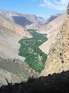
 The Marghab in theBadghis Province | |
 Marghab River watershed, upstream of Saryyazy Reservoir (Interactive map) | |
| Etymology | PersianMarv-ab,"River ofMerv"[1][2] |
| Native name | |
| Location | |
| Countries | Afghanistan,Turkmenistan |
| Physical characteristics | |
| Source | |
| • location | Selseleh-ye Safīd Kūh,Marghab District,Afghanistan |
| • coordinates | 35°09′N65°59′E/ 35.15°N 65.99°E |
| Mouth | |
• location | Mary Oasis(ultimately theAral SeaviaAmu Darya) |
| Length | ~850 km (530 mi) |
| Basin size | 34,700 km2(13,400 sq mi) (Harirod-Murghab basin)[3] |
| Discharge | |
| • average | 48.7 m3/s (1,720 cu ft/s) |
| Basin features | |
| River system | Amu Darya |
TheMarghab River(Persian/Pashto:مرغاب,Morqâb,Balochi:مرگاپ), anciently theMargiana(Ancient Greek:Μαργιανή,Margianḗ), is an 850-kilometre (530 mi) long river inCentral Asia.It rises in theParopamisus Mountains(Selseleh-ye Safīd Kūh) inGhor Province,flows through theMarghab Districtin centralAfghanistan,then runs northwest towards theBala Murghab.Reaching the oasis ofMaryin theKarakum DesertofTurkmenistan,the Marghab debouches into theKarakum Canal,a diversion of water from theAmu Darya.The catchment area of the Marghab is estimated at 46,880 square kilometres (18,100 sq mi).[4]
Geography[edit]
The Marghab River originates in theGhor Provinceof central Afghanistan, on a plateau among the chain of mountains ofParopamisus,GharjistanandBand-i Turkestan.In its higher course, the river runs from east to west, towards Mukhamedkhan, for about 300 kilometres (190 mi) in a narrow, steep valley measuring less than one kilometer in width, with narrow gorges in some places.
BetweenDarband-i KilrekhtandMukhammedkhan,the Marghab crosses the western part of Band-i Turkestan, and then runs toward the northwest in a deep canyon. At Mukhammedkhan, it crosses the gorges ofJaokar.After this, the valley widens somewhat, gradually reaching a width of 2 kilometres (1.2 mi) in Turkmenistan. Beyond Mukhamedkhan, a small portion of the water of the Marghab is used for irrigation; approximately 10,000 hectares (25,000 acres) are irrigated from the Marghab in Afghanistan. The Marghab receives the waters of theKaysar riveron the right, then forms the border between Turkmenistan and Afghanistan over 16-kilometre (10 mi) length.
In Turkmenistan, close toTagtabazar,the Marghab receives theKashan Riverfrom the left bank, and 25 kilometres (16 mi) further, there is the confluence of theKushk.Downstream of the confluence with the Kushk lies the Saryyazy reservoir, built in 1959, and expanded in 1978. The reservoir and its surrounding area is ecologically important for birds.[5]Reaching the oasis ofMary,the Marghab mingles its waters with those of theKarakum Canal,a diversion of water from theAmu Darya.
-
 The fertile Marghab Valley in Afghanistan
 -
 A bridge across the Marghab in 1962
 -
 Thegeneratorsof Hindu Kush hydro power plant (Гиндукушская ГЭС) on Marghab River soon after its completion in 1909 by theHungarianGanz Works.At the time, it was the largest hydro power generating station of theRussian Empire


Hydrometry: the flows at Tagtabazar[edit]
The flow of Marghab was observed during 50 years (1936–85) atTagtabazar,a location in Turkmenistan about 30 kilometres (19 mi) after the Marghab leaves the Afghan territory, and a score of kilometers upstream of the confluence with theKushk.[6]At Tagtabazar, average annual flow observed over this period was 48.7 cubic metres per second (1,720 cu ft/s) for an observed surface area of 34,700 square kilometres (13,400 sq mi), which is 74 percent of the totality of thecatchment areaof the river. The geographically-averaged hydrometric flow passing through this part of the basin, by far greatest from the point of view of the flow, thus reached the figure of 44.3 millimeters per annual, which is very appreciable in this particularly desiccated area.
Monthly mean flows of Murghab (in cubic meters per second) measured at the hydrometric station of Tagtabazar
Data calculated over 50 years

A 2021 study indicates that in the near term (by 2040), the Marghab's flow could fall by as much as one-third due to climate change, and by 40 percent by the end of the 21st century.[7]
References[edit]
- ^Rawlinson, George (January 19, 2018).A Short History of Persia.Ozymandias Press.ISBN9781531277079– via Google Books.
- ^Strange, G. Le (June 16, 2011).The Lands of the Eastern Caliphate.Cambridge University Press.ISBN9781107600140– via Google Books.
- ^https://www.moore.af/MediaLibsAndFiles/media/afghanistan.moore-global.com/files/Research/17-Afghanistan-Water-Management.pdf[bare URL PDF]
- ^"Surface water resources in North Afghanistan".Archived fromthe originalon July 23, 2011.
- ^"BirdLife Data Zone".Retrieved2023-11-20.
- ^UNESCO - Bassin du Murghab - Station: Takhta-BazarArchived2016-03-03 at theWayback Machine
- ^Didovets, Iulii; Lobanova, Anastasia; Krysanova, Valentina; Menza, Christoph; Babagalieva, Zhanna; Nurbatsina, Aliya; Gavrilenko, Nadejda; Khamidov, Vohid; Umirbekov, Atabek; Qodirov, Sobir; Muhyyew, Dowletgeldi; Hattermann, Fred Fokko (April 2021)."Central Asian rivers under climate change: Impacts assessment in eight representative catchments".Journal of Hydrology: Regional Studies.34(100779): 100779.Bibcode:2021JHyRS..3400779D.doi:10.1016/j.ejrh.2021.100779.hdl:10419/229441.S2CID233532220.
External links[edit]
- Murgap river(Murghab river) marked on the OpenStreetMap
- Morghab River,in Encyclopædia Britannica
- Map of the province of Ghor, with trace of the flow of waterArchived29 June 2006 at theWayback Machine
- Map of vegetation cover in the province of Badghis, with trace of the flow of waterArchived29 June 2006 at theWayback Machine
- "Delft Hydraulics - Integrated Water Resources Management for the Sistan Closed Inland Delta - ANNEX B: Forecasting the Flow from Afghanistan - Page 18: cartes hydrographiques d'Afghanistan"(PDF).[permanent dead link](1.50 MB)(in English)
36°26′47″N62°38′06″E/ 36.44639°N 62.63500°E
| Rivers | |
|---|---|
| Canal | |
| River (extinct) | |
| National | |
|---|---|
| Geographic | |