
Nandu River
| Nandu River | |
|---|---|
 Nandu River atLongtangjust north of the town and south of theLongtang Dam,on the west side, facing southeast | |
| Native name | Nam độ giang(Chinese) |
| Location | |
| Country | People's Republic of China |
| Province | Hainan |
| Physical characteristics | |
| Mouth | |
• location | Qiongzhou Strait |
| Length | 314 km (195 mi) |
| Basin size | 150×106m3(5.3×10⁹cu ft) Fengtan Reservoir, Forge Reservoir, East Lake[1] |
| Discharge | |
| • average | 6.099×10⁹m3/a (193.3 m3/s; 6,825 cu ft/s)[citation needed] |
TheNandu River(Chinese:Nam độ giang) is the longest river inHainanProvince, China.[1]Its tributary is theXinwu River.The river discharges into the Nandu River estuary atHaikoucity, and then intoQiongzhou Strait.[2]
The river is 314 km long, with a discharge of 6.099 billion cubic metres. It passes the major settlements of Chengmai Zhen inChengmai CountythenDingchenginDing'an County.The river then turns north, goes over theLongtang DamatLongtang,a somewhat smaller town than Chengmai and Ding'an. The Nandu then goes under several bridges, such as theNandu River Iron BridgeandQiongzhou Bridge.Once passed the Qiongzhou Bridge, at the southern tip ofXinbu Island,the Nandu flows north along the east side of Xinbu Island and out into the sea. At the southern tip of Xinbu Island, twodistributariesbranch off. One is the Henggouhe Channel which runs along the west side of Xinbu Island. The other is the smallerHaidian Riverwhich flows westward, under theHaikou Century Bridge,and out intoHaikou Bay.
Bridges[edit]

From Chengmai Zhen inChengmai Countyat the west to its mouth at Haikou there are numerous bridges crossing the Nandu River. Some are semi-permanent and get washed out during times of high water, while other, major bridges are currently under construction. The following is a fairly comprehensive list of landmarks and bridges between Chengmai Zhen and Haikou City.
|
|
Flooding[edit]

The Nandu occasionally floods its banks. For that reason, preventative measures have been taken. For example, near Haikou and in other parts, levees were built, andflood wallswere constructed on the west bank nearDingcheng.
One instance of flooding occurred at a sharp bend in the river at Bushicun village. There in August 2016, on the outside bend, as it had before, water surged and flooded onto the land. The ground there, several metres above normal river level, is strewn with rusted boat hulls from previous floods.19°49′15″N110°23′45″W/ 19.8207°N 110.3957°W
Gallery[edit]
-
 Map
Map -

-
-
 Nandu River Damlocated byLongtang
 -

-
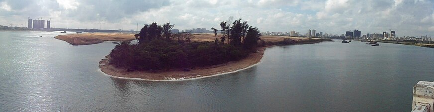
 End of Nandu river flowing aroundXinbu Island(right) intoQiongzhou Strait(left)


See also[edit]
References[edit]
- ^abVô tiêu đề văn đương.Haikou.gov.cn. Archived fromthe originalon 2010-06-08.Retrieved2010-07-30.
- ^"Haikou - CNSeeker".China-map.cnseeker.com. 2010-01-12.Retrieved2010-07-30.
External links[edit]
- Table of rivers in Chinawith Chinese names and useful data
19°59′52″N110°23′08″E/ 19.9979°N 110.3856°E
Hainan topics | |
|---|---|
| General | |
| Geography | |
| Flora and fauna | |
| Media | |
| Transportation | |
| Education | |
| Demographics | |
| Buildings and structures | |
| Cuisine | |
| Visitor attractions | |
| Yangtzesystem | |
|---|---|
| Yellowsystem | |
| Pearlsystem | |
| Heilongjiangsystem | |
| Huaisystem | |
| Haisystem | |
| Liaosystem | |
| Other major rivers | |
| Major canals | |