
Naryn
Naryn
Нарын | |
|---|---|
 Overlook of Naryn from the south | |
 Flag  Seal | |
 Naryn Location in Kyrgyzstan | |
| Coordinates:41°26′N76°0′E/ 41.433°N 76.000°E | |
| Country | |
| Region | |
| Founded | 1868 |
| Government | |
| •Mayor | Kanbolot Tutuev |
| Area | |
| • Total | 84 km2(32 sq mi) |
| Elevation | 2,044 m (6,706 ft) |
| Population (2023)[1] | |
| • Total | 41,988 |
| • Rank | 9th |
| • Density | 500/km2(1,300/sq mi) |
| Time zone | UTC+6(KGT) |
| 722900 | 722600 |
| Area code | 722600 |
Naryn(Kyrgyz:Нарын,romanized:Naryn,نارىن) is the regional administrative center ofNaryn Regionin centralKyrgyzstan.Its area is 84 square kilometres (32 sq mi),[2]and its estimated population was 41,178 as of January 2021.[1]The town was established as a fortress on the caravan route in 1868.[3]It is situated on both banks of the riverNaryn(one of the main headwaters of theSyr Darya), which cuts a picturesque gorge through the town. The city has two regional museums and some hotels, but is otherwise residential.
History
[edit]
Naryn was established as a fortress on the important caravan route betweenKashgarandZhetysu(Semirechye) at the direction of the first Governor-General of Russian TurkestanKonstantin Petrovich von Kaufmannin 1868.[4]
Overview
[edit]From Naryn, the main road (one of the branches of the ancientSilk Road) runs south through the sparsely settled central Kyrgyz highlands to theTorugart PassandChina.At present, this is the main transport link from Kyrgyzstan to China. Naryn hosts one of threecampusesof theUniversity of Central Asia(UCA).Theuniversitywas founded in 2000 by the governments ofKazakhstan,theKyrgyz RepublicandTajikistan,andHis Highness the Aga Khan.It is the world's first internationally chartered institution of higher education. The UCA currently operates aSchool of Professional and Continuing Education(SPCE),with aSchool of Undergraduate Studiesand aGraduate School of Developmentin the process of being established. Undergraduate classes at theUniversity of Central Asia’s (UCA) Naryn, Kyrgyz Republic campus commenced on 5 September 2016.[5]
-
 Apartment buildings in Naryn
 -
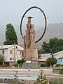 Statue in the main square of Naryn
 -
 Countryside around Naryn.


| Year | Pop. | ±% p.a. |
|---|---|---|
| 1926 | 1,632 | — |
| 1959 | 6,033 | +4.04% |
| 1970 | 20,836 | +11.93% |
| 1979 | 29,833 | +4.07% |
| 1989 | 42,210 | +3.53% |
| 1999 | 40,050 | −0.52% |
| 2009 | 34,822 | −1.39% |
| 2021 | 41,178 | +1.41% |
| 2023 | 41,988 | +0.98% |
| Sources:[7][8][2][1] | ||
Demographics
[edit]Naryn is the tenth largest city by population in Kyrgyzstan. Its resident population, according to the Population and Housing Census of 2009, was 34,822.[2]According to the National Statistical Committee the population of Naryn amounted to 41,178 as of January 2021.[1]
Economics
[edit]The economy of the Province is dominated by animal husbandry such as horse, sheep and yak, and wool and meat being the main products. Today, the district is the poorest region in the country. The mineral mines developed during theSovietperiod were largely abandoned after the fall of communism as they were not profitable.
Climate
[edit]Naryn has acold semi-arid climate(Köppen climate classificationBSk) with strongcontinentaltendencies.
| Climate data for Naryn (1991–2020, extremes 1913–present) | |||||||||||||
|---|---|---|---|---|---|---|---|---|---|---|---|---|---|
| Month | Jan | Feb | Mar | Apr | May | Jun | Jul | Aug | Sep | Oct | Nov | Dec | Year |
| Record high °C (°F) | 5.3 (41.5) |
9.1 (48.4) |
20.5 (68.9) |
29.5 (85.1) |
29.6 (85.3) |
33.1 (91.6) |
36.9 (98.4) |
36.0 (96.8) |
31.4 (88.5) |
26.6 (79.9) |
19.0 (66.2) |
9.0 (48.2) |
36.9 (98.4) |
| Mean daily maximum °C (°F) | −8.7 (16.3) |
−5.0 (23.0) |
4.4 (39.9) |
14.4 (57.9) |
18.7 (65.7) |
22.0 (71.6) |
25.3 (77.5) |
25.4 (77.7) |
21.5 (70.7) |
13.6 (56.5) |
4.8 (40.6) |
−5.7 (21.7) |
10.9 (51.6) |
| Daily mean °C (°F) | −14.8 (5.4) |
−11.0 (12.2) |
−1.1 (30.0) |
8.1 (46.6) |
12.1 (53.8) |
15.2 (59.4) |
17.8 (64.0) |
17.7 (63.9) |
13.8 (56.8) |
6.4 (43.5) |
−1.5 (29.3) |
−11.4 (11.5) |
4.3 (39.7) |
| Mean daily minimum °C (°F) | −19.4 (−2.9) |
−15.9 (3.4) |
−5.9 (21.4) |
2.3 (36.1) |
6.1 (43.0) |
8.8 (47.8) |
10.6 (51.1) |
10.3 (50.5) |
6.5 (43.7) |
0.8 (33.4) |
−5.9 (21.4) |
−15.7 (3.7) |
−1.4 (29.4) |
| Record low °C (°F) | −37.9 (−36.2) |
−38.0 (−36.4) |
−27.6 (−17.7) |
−15.5 (4.1) |
−5.7 (21.7) |
−1.0 (30.2) |
0.6 (33.1) |
0.6 (33.1) |
−7.4 (18.7) |
−14.9 (5.2) |
−29.2 (−20.6) |
−35.4 (−31.7) |
−38.0 (−36.4) |
| Averageprecipitationmm (inches) | 9 (0.4) |
15 (0.6) |
22 (0.9) |
35 (1.4) |
65 (2.6) |
66 (2.6) |
44 (1.7) |
24 (0.9) |
14 (0.6) |
17 (0.7) |
16 (0.6) |
13 (0.5) |
340 (13.5) |
| Average precipitation days(≥ 1.0 mm) | 3.1 | 5.8 | 5.6 | 6.8 | 9.4 | 10.0 | 7.2 | 4.4 | 3.3 | 3.3 | 3.3 | 2.7 | 62.9 |
| Averagerelative humidity(%) | 76 | 74 | 71 | 60 | 54 | 57 | 55 | 50 | 45 | 52 | 63 | 74 | 61 |
| Mean monthlysunshine hours | 135 | 145 | 178 | 210 | 246 | 292 | 320 | 316 | 274 | 218 | 156 | 122 | 2,612 |
| Source 1: Pogoda.ru.net[9] | |||||||||||||
| Source 2:Deutscher Wetterdienst(humidity 1961–1990)[10]NOAA (precipitation days and sun 1961–1990)[11] | |||||||||||||
References
[edit]- ^abcd"Population of regions, districts, towns, urban-type settlements, rural communities and villages of Kyrgyz Republic"(XLS)(in Russian). National Statistics Committee of the Kyrgyz Republic. 2021.Archivedfrom the original on 10 November 2021.
- ^abc"2009 population and housing census of the Kyrgyz Republic: Naryn Region"(PDF)(in Russian). National Statistics Committee of the Kyrgyz Republic. 2010. pp. 12, 15, 39, 145.
- ^Иссык-Куль. Нарын. Энциклопедия.[Issyk-Kul. Naryn.Encyclopedia.] (in Russian). Frunze: Chief Editorial Board of Kyrgyz Soviet Encyclopedia. 1991. p. 512.ISBN5-89750-009-6.
- ^Pavlov, N. (1910).The history of Turkestan(in Russian). p. 143.Retrieved2019-07-20.
- ^"Classes Begin for the University of Central Asia's First Undergraduate Students".University of Central Asia.Archived fromthe originalon 26 October 2017.Retrieved10 October2016.
- ^Info on www.canadabandy.caArchived2005-08-28 at theWayback Machine
- ^"Всесоюзная перепись населения 1926 года: Киргизская АССР. (All-Union Census of 1926: Kyrgyz ASSR)".Moscow: CSU SSSR. 1928. Archived fromthe originalon 2011-07-22.Retrieved2013-04-14.
- ^Всесоюзная перепись населения 1959 г.All Union Census of 1959. (Demoscope.ru)(in Russian)
- ^ "Климат Нарын"(in Russian). Weather and Climate (Погода и климат). Archived fromthe originalon 23 January 2021.Retrieved28 October2021.
- ^ "Klimatafel von Naryn (Narynskoje) / Kirgisistan"(PDF).Baseline climate means (1961-1990) from stations all over the world(in German). Deutscher Wetterdienst.Retrieved18 February2016.
- ^"Naryn (MTN STN) Climate Normals 1961–1990".National Oceanic and Atmospheric Administration.Retrieved28 October2021.
External links
[edit]![]() Media related toNaryn (town)at Wikimedia Commons
Media related toNaryn (town)at Wikimedia Commons
- Celestial Mountains Travel Encyclopedia of Kyrgyzstan[English]
- Photos from Naryn[English]
Administrative seats of theregionsofKyrgyzstan | |||
|---|---|---|---|